Podcast
Questions and Answers
What is the flow direction of the Awash River in the Rift Valley?
What is the flow direction of the Awash River in the Rift Valley?
- Southeast
- Northwest
- Southwest
- Northeast (correct)
Which lake is the largest in the maze of lakes and marshes where the Awash River terminates?
Which lake is the largest in the maze of lakes and marshes where the Awash River terminates?
- Lake Afrera
- Lake Abaya
- Lake Tana
- Lake Abe (correct)
What characterizes the Afar drainage sub-basin?
What characterizes the Afar drainage sub-basin?
- High evaporation rates and very little stream flow (correct)
- Frequent flooding and river overflow
- Abundant rainfall and lush vegetation
- Year-round temperate climate
What is the primary reason for the formation of Lake Afrera and Asale?
What is the primary reason for the formation of Lake Afrera and Asale?
Which rivers flow into Lake Ziway?
Which rivers flow into Lake Ziway?
What term best describes the southern part of the Rift Valley sub-basin?
What term best describes the southern part of the Rift Valley sub-basin?
How do the lakes in the Rift Valley sub-basin primarily collect water?
How do the lakes in the Rift Valley sub-basin primarily collect water?
What do Lakes Ziway and Langano have in common?
What do Lakes Ziway and Langano have in common?
What geographical feature primarily defines the lakes in the Rift Valley region?
What geographical feature primarily defines the lakes in the Rift Valley region?
What is a major characteristic of the streams in the Rift Valley drainage systems?
What is a major characteristic of the streams in the Rift Valley drainage systems?
What is the largest drainage system in Ethiopia in terms of area covered?
What is the largest drainage system in Ethiopia in terms of area covered?
Which river in the Western Drainage System flows southward unlike others?
Which river in the Western Drainage System flows southward unlike others?
What percentage of the annual water flow is carried by the Abay River basin?
What percentage of the annual water flow is carried by the Abay River basin?
Which river is classified as a tributary of the Nile after joining it in Sudan?
Which river is classified as a tributary of the Nile after joining it in Sudan?
What is the estimated mean annual flow of the Ghibe (Omo) River?
What is the estimated mean annual flow of the Ghibe (Omo) River?
Which river system does not reach the Indian Ocean at its end?
Which river system does not reach the Indian Ocean at its end?
What geographical feature primarily influences the drainage systems in Ethiopia?
What geographical feature primarily influences the drainage systems in Ethiopia?
Which river basin is the largest in terms of catchment area in the Southeastern Drainage System?
Which river basin is the largest in terms of catchment area in the Southeastern Drainage System?
Which river is the most utilized in Ethiopia?
Which river is the most utilized in Ethiopia?
Which river basin in Ethiopia is primarily characterized by an inland drainage system?
Which river basin in Ethiopia is primarily characterized by an inland drainage system?
What percentage of the earth’s total surface is covered by water bodies?
What percentage of the earth’s total surface is covered by water bodies?
How much of the earth's total water is classified as fresh water?
How much of the earth's total water is classified as fresh water?
Which of the following represents the largest portion of fresh water supplies?
Which of the following represents the largest portion of fresh water supplies?
What is the estimated surface water potential of Ethiopia?
What is the estimated surface water potential of Ethiopia?
Which term best describes the flow of water through well-defined channels?
Which term best describes the flow of water through well-defined channels?
A drainage basin is defined as what?
A drainage basin is defined as what?
What geographical characteristic contributes to Ethiopia being referred to as the 'water tower of Eastern Africa'?
What geographical characteristic contributes to Ethiopia being referred to as the 'water tower of Eastern Africa'?
What primarily determines the drainage pattern of an area?
What primarily determines the drainage pattern of an area?
Which of the following is NOT a component of fresh water distribution?
Which of the following is NOT a component of fresh water distribution?
What does the term 'mouth' refer to in the context of a drainage system?
What does the term 'mouth' refer to in the context of a drainage system?
Flashcards
Drainage System
Drainage System
The flow of water within a well-defined channel, forming a branched network of interconnected streams and their surrounding land area.
Headwater/Source
Headwater/Source
A river's starting point, where water flows from a source like a spring or mountain area.
Mouth
Mouth
The point where a river ends, usually emptying into a larger body of water like an ocean, lake, or another river.
Drainage Basin
Drainage Basin
Signup and view all the flashcards
Watershed/Topographic Divide
Watershed/Topographic Divide
Signup and view all the flashcards
Drainage Pattern
Drainage Pattern
Signup and view all the flashcards
Surface Water
Surface Water
Signup and view all the flashcards
Ground Water
Ground Water
Signup and view all the flashcards
River
River
Signup and view all the flashcards
Major Drainage Systems
Major Drainage Systems
Signup and view all the flashcards
Rift Valley Drainage
Rift Valley Drainage
Signup and view all the flashcards
Awash River Flow
Awash River Flow
Signup and view all the flashcards
Awash River Outlet
Awash River Outlet
Signup and view all the flashcards
Afar Drainage
Afar Drainage
Signup and view all the flashcards
Afar Lakes
Afar Lakes
Signup and view all the flashcards
Southern Rift Valley Sub-basin
Southern Rift Valley Sub-basin
Signup and view all the flashcards
Lake Locations
Lake Locations
Signup and view all the flashcards
Lake Water Supply
Lake Water Supply
Signup and view all the flashcards
River-Lake Connections
River-Lake Connections
Signup and view all the flashcards
Interconnected Lakes
Interconnected Lakes
Signup and view all the flashcards
Western Drainage Systems
Western Drainage Systems
Signup and view all the flashcards
Southeastern Drainage Systems
Southeastern Drainage Systems
Signup and view all the flashcards
Rift Valley Drainage System
Rift Valley Drainage System
Signup and view all the flashcards
Abay (Blue Nile)
Abay (Blue Nile)
Signup and view all the flashcards
Tekeze River
Tekeze River
Signup and view all the flashcards
Baro-Akobo River
Baro-Akobo River
Signup and view all the flashcards
Awash River
Awash River
Signup and view all the flashcards
Ghenale River
Ghenale River
Signup and view all the flashcards
Wabishebelle River
Wabishebelle River
Signup and view all the flashcards
Topography
Topography
Signup and view all the flashcards
Study Notes
Water Resources of Ethiopia
- 71% of Earth's surface is water, predominantly seas and oceans
- Nearly 97.5% of Earth's water is saltwater
- 2.5% of water is freshwater, distributed in glaciers (68.7%), groundwater (30.1%), permafrost (0.8%), and surface water (0.4%)
- Surface water includes water in lakes, rivers, atmosphere, soils, and wetlands
- Freshwater is unevenly distributed globally, influenced by latitude, climate, and topography
- Ethiopia has a complex topography (highlands, rugged terrain, low plains), higher rainfall, and equatorial proximity that contribute to significant surface and groundwater resources
- 0.7% of Ethiopia’s land area is water bodies
- Surface water potential in Ethiopia is estimated at 124.4 billion cubic meters (BCM)
- Ethiopia is considered the "water tower" of Eastern Africa
Major Drainage Systems of Ethiopia
- Drainage is the flow of water through defined channels
- A drainage system consists of a main river and its tributaries, flowing from a source (headwater) to a mouth
- Drainage patterns are influenced by geology, rock structure, topography, and water flow
- A drainage basin is an area where a river and its tributaries collect surface and subsurface water, bounded by a water divide
- Ethiopia's drainage patterns are shaped by outward-sloping plateaus, inward-sloping Rift Valley escarpments, and geological faults
- Ethiopia's drainage systems are broadly classified into Western, Southeastern, and Rift Valley systems
Western Drainage System
- Largest drainage system, covering 40% of Ethiopia's area and carrying 60% of annual water flow
- Four major river basins: Tekeze, Abay, Baro-Akobo, Ghibe (Omo)
- Ghibe (Omo) flows southward, while Abay, Tekeze, and Baro flow westward to the Nile
- Abay is the largest river in the Western system. Its basin covers 199,812 km2, and carries 65% of annual water flow, rising from Lake Tana & joins the White Nile in Khartoum
- Tekeze (Atbara in Sudan) drains 82,350 km2 and carries 12% of annual water flow, flowing to the Nile
- Baro-Akobo carries 17% of annual flow
- Ghibe / Omo carries 6 % of annual flow and empties into Lake Turkana
Southeastern Drainage System
- Drains most of southeastern Ethiopia
- Primarily drained by Wabishebelle and Ghenale rivers, sloping southeastward across plains
- Major highlands include the Arsi, Bale, Sidama, and Harerghe plateaus
- Wabishebelle is the largest river in terms of catchment area (202,697 km2) and the longest in Ethiopia, flowing parallel to the coast before disappearing into the sand near the Juba River
- Ghenale (Juba River in Somalia) drains a basin of 171,042 km2, carrying more water than Wabishebelle and reaching the Indian Ocean
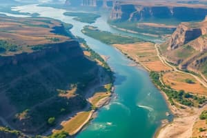
Rift Valley Drainage System
- Characterized by low rainfall, high evaporation, and small catchment areas, flowing in various directions
- Primarily drained by the Awash River, which originates from the Shewan plateau, flows 1,250 km, and covers parts of multiple regions. It's the most utilized river
- Awash flows northeast, ending in a maze of small lakes and marshlands (Lake Abe)
- Afar sub-basin lacks significant stream flow, with Lake Afrera and Asale being the main surface waters (tectonically formed)
- Southern Rift Valley sub-basin has numerous lakes and small streams, interconnected (e.g., Ziway, Langano, Abijata)
Studying That Suits You
Use AI to generate personalized quizzes and flashcards to suit your learning preferences.