Podcast
Questions and Answers
Soil detachment and transport resulting from the direct impact of water drops on soil particles is known as what type of erosion?
Soil detachment and transport resulting from the direct impact of water drops on soil particles is known as what type of erosion?
- Interill Erosion
- Sheet Erosion
- Rill Erosion
- Raindrop Erosion (correct)
If the rainfall intensity (i) is 25 mm/h, what is the kinetic energy (E) of the rainfall, using the formula E = 0.119 + 0.0873log(i) ?
If the rainfall intensity (i) is 25 mm/h, what is the kinetic energy (E) of the rainfall, using the formula E = 0.119 + 0.0873log(i) ?
- 0.23 MJ/ha-mm
- 0.56 MJ/ha-mm
- 0.34 MJ/ha-mm (correct)
- 0.45 MJ/ha-mm
What type of erosion is defined as the uniform removal of soil layers from sloping land due to sheet or overland flow?
What type of erosion is defined as the uniform removal of soil layers from sloping land due to sheet or overland flow?
- Rill Erosion
- Interill Erosion
- Gully Erosion
- Sheet Erosion (correct)
Which type of erosion combines the effects of splash erosion and sheet erosion?
Which type of erosion combines the effects of splash erosion and sheet erosion?
In the interill erosion equation, $D = KiS$, what does the 'K' represent?
In the interill erosion equation, $D = KiS$, what does the 'K' represent?
Detachment and transport of soil by concentrated water flow is characteristic of which type of erosion?
Detachment and transport of soil by concentrated water flow is characteristic of which type of erosion?
According to the rill erosion equation what does $T_c$ represent?
According to the rill erosion equation what does $T_c$ represent?
Which type of erosion forms channels that are larger than rills and cannot be removed by tillage?
Which type of erosion forms channels that are larger than rills and cannot be removed by tillage?
What process involves the removal of soil from stream banks or soil movement within the stream channel?
What process involves the removal of soil from stream banks or soil movement within the stream channel?
According to the equation $T_c= Bτ^{1.5}$, what does 'B' represent?
According to the equation $T_c= Bτ^{1.5}$, what does 'B' represent?
What does 'A' represent in the Universal Soil Loss Equation (USLE), $A = RKLSCP$?
What does 'A' represent in the Universal Soil Loss Equation (USLE), $A = RKLSCP$?
In the Universal Soil Loss Equation (USLE), which factor accounts for the protective quality of different types of vegetation?
In the Universal Soil Loss Equation (USLE), which factor accounts for the protective quality of different types of vegetation?
In the Universal Soil Loss Equation (USLE), what does the 'P' factor represent:
In the Universal Soil Loss Equation (USLE), what does the 'P' factor represent:
According to the equation for an unknown K of a given soil, $𝐾=2.8×10^{-3}𝑀 [12−𝑎]+4.3×10^{-3} (𝑏−2)+3.3𝑥10^{-3}(𝑐−3))$, what does 'M' represent?
According to the equation for an unknown K of a given soil, $𝐾=2.8×10^{-3}𝑀 [12−𝑎]+4.3×10^{-3} (𝑏−2)+3.3𝑥10^{-3}(𝑐−3))$, what does 'M' represent?
When calculating the slope length factor (L), what does 'l' represent in the equation $L = (l/20)^m$?
When calculating the slope length factor (L), what does 'l' represent in the equation $L = (l/20)^m$?
Which of the following is considered a primary factor affecting erosion caused by wind?
Which of the following is considered a primary factor affecting erosion caused by wind?
What types of soil are stated as being most susceptible to wind erosion damage?
What types of soil are stated as being most susceptible to wind erosion damage?
According to the wind distribution formula, what does 'z' represent?
According to the wind distribution formula, what does 'z' represent?
What is the typical measure for von Karman's constant?
What is the typical measure for von Karman's constant?
If the crop height (h) is 1 meter, what is the effective roughness height (d) for wind erosion calculation, using the formula $d = 0.7h$?
If the crop height (h) is 1 meter, what is the effective roughness height (d) for wind erosion calculation, using the formula $d = 0.7h$?
What is the first step in the process of wind erosion?
What is the first step in the process of wind erosion?
What is the name of the wind erosion process governed by particle size, wind velocity and distance across the eroding area?
What is the name of the wind erosion process governed by particle size, wind velocity and distance across the eroding area?
The soil erodibility index is described by which formula:
The soil erodibility index is described by which formula:
What is the correct formula for the Ridge Roughness factor K?
What is the correct formula for the Ridge Roughness factor K?
What does the parameter 'L' represent when estimating wind erosion?
What does the parameter 'L' represent when estimating wind erosion?
Flashcards
What is Raindrop Erosion?
What is Raindrop Erosion?
Soil detachment and transport resulting from the impact of water drops on soil.
What is Sheet Erosion?
What is Sheet Erosion?
Uniform removal of soil layers from sloping land due to sheet or overland flow.
What is Interill Erosion?
What is Interill Erosion?
A combination of splash and sheet erosion processes.
What is Rill Erosion?
What is Rill Erosion?
Signup and view all the flashcards
What is Gully Erosion?
What is Gully Erosion?
Signup and view all the flashcards
What is Stream Channel Erosion?
What is Stream Channel Erosion?
Signup and view all the flashcards
What is USLE?
What is USLE?
Signup and view all the flashcards
Factors Affecting Water Erosion
Factors Affecting Water Erosion
Signup and view all the flashcards
Factors Affecting Wind Erosion
Factors Affecting Wind Erosion
Signup and view all the flashcards
Areas Subject to Wind Erosion
Areas Subject to Wind Erosion
Signup and view all the flashcards
What are the Phases of Wind Erosion?
What are the Phases of Wind Erosion?
Signup and view all the flashcards
What is E= f(I, K, C, L,V)?
What is E= f(I, K, C, L,V)?
Signup and view all the flashcards
Roughness factor (K)
Roughness factor (K)
Signup and view all the flashcards
Climate Factor (K) in Wind Erosion
Climate Factor (K) in Wind Erosion
Signup and view all the flashcards
Unsheltered Distance (L)
Unsheltered Distance (L)
Signup and view all the flashcards
Vegetative Cover Factor (V)
Vegetative Cover Factor (V)
Signup and view all the flashcards
Study Notes
Water Erosion
- Factors affecting erosion by water includes climate, soil, vegetation, and topography.
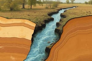
- Raindrop Erosion is soil detachment and transport resulting from the impact of water drops directly on soil particles or thin water surfaces.
- E = kinetic energy in MJ/ha-mm
- i = intensity of rainfall in mm/h
- E= 0.119 + 0.0873log I
Sheet and Interill Erosion
- Sheet Erosion is the uniform removal of soil layers from sloping land, resulting from sheet or overland flow.
- Interill Erosion is splash and sheet erosion combined.
- D = interill erosion rate in kg/m-s
- Ķ = interill erodibility in kg-s/m
- i = rainfall intensity in m/s
- S = slope factor = 1.05 - 0.485^A
- where A = slope in degrees
- D = KiS
Rill Erosion
- Rill Erosion is the detachment and transport of soil by a concentrated flow of water.
- Dr = rill detachment rate in kg/m-s
- Kr = rill erodibility resulting from shear in s/m
- τ’ = hydraulic shear of flowing water with units in Pa, pgrs
- τc = critical shear below which no erosion occurs with units in Pa
- Qs = rate of sediment flow in the rill with units in kg/m-s
- Tc = sediment transport capacity of rill in kg/m-s
- p = density of water in kg/m
- g = acceleration due to gravity in m/s
- r = hydraulic radius of rill in m
- s = hydraulic gradient of rill flow
- Dr = Κr(τ -τc)(1- Q/T)
Gully and Stream Channel Erosion
- Gully Erosion produces channels larger than rills, carrying water during and immediately after rains and cannot be obliterated by tillage.
- Stream Channel Erosion consists of soil removal from stream banks or soil movement in the channel.
- Sediment Transport:
- T = transport capacity per unit width in kg/m-s
- B = transport coefficient based on soil and water properties
- τ = hydraulic shear of rill channel in Pa
- Tc = Bτ^.5
Soil Loss Equation
- Universal Soil Loss Equation (USLE):
- A = average annual soil loss in Mg/ha
- R = rainfall and runoff erosivity index for geographic location
- K = soil erodibility factor
- L = slope length factor
- S = slope steepness factor
- C = cover management factor
- P = conservation practice factor
- A = RKLSCP
- R (Rainfall Factor) is the product of the kinetic energy of the storm and the maximum 30-minute intensity of that storm.
Calculating an Unknown K
- M = particle size parameter (%silt + %very fine sand) x (100 - %clay)
- a = percent organic matter
- b = soil structure code
- 1 = very fine granular
- 2 = fine granular
- 3 = medium or coarse granular
- 4 = blocky, platy, or massive
- c = profile permeability class
- 1 = rapid
- 2 = moderate to rapid
- 3 = moderate
- 4 = slow to moderate
- 5 = slow
- 6 = very slow
- K = 2.8x10^-5M {12-a) + 4.3x10^-3 (b-2) + 3.3x10^-3 (c-3)}
Determining Slope Characteristics
- Factors for slope length:
- L = slope length factor
- l = slope length in m
- m = dimensionless exponent
- L = (l/20)^m
- Recommended for conditions where rill erosion and interill erosion were about equal on a 9 percent, 22m long slope, the m can be determined by calculating:
- m = [sinθ/(sinθ+0.269 (sin θ +0.05))]
- θ = field slope steepness in degrees = tan (s/100)
- s = field slope in percent
- Equation for when Slopes are Shorter than 4m:
- S = 3.0(sinθ)^0.8 + 0.56
- Equation for when Slopes are Longer than 4m and s is less than 9 percent:
- S = 10.8 sinθ + 0.03
- Equation for when Slopes are Longer than 4m and s is greater than 9 percent:
- S = 16.8 sinθ + 0.50
Cover Management Factors
- Using vegetation cover to reduce soil loss.
- Follow/Bared land has a C factor of 1.0.
- Paddy field has a C factor of 0.34.
- Upland has a C factor of 0.31.
- Grassland (95~100% cover) Grass has a C factor of 0.003.
- Grassland Weeds has a C factor of 0.01.
- Grass (80% cover) Grass has a C factor of 0.01.
- Grass (80% cover) Weeds has a C factor of 0.04.
- Forest Weeds has a C factor of 0.09.
- Forest (75~100% cover) factor of 0.01.
- Forest (40
75% cover) factor of 0.0020.004. - Forest (20
40% cover) factor of 0.0030.01.
Conservation Practice Factor Equations
- Pc = contouring factor base on slope
- sP = strip cropping factor recommended
- tP = terrace sedimentation factor
- To determine the Conservation practice factor
- P= Pc x Ps x Pt
- For contour farming, land slope (percent) of "1 to 2" has factors of "0.6 Contour" and "0.3 Strip crop".
- For contour farming, land slope (percent) of "3 to 5" has factors of "0.5 Contour" and "0.25 Strip crop".
- For contour farming, land slope (percent) of "6 to 8" has factors of "0.5 Contour" and "0.25 Strip crop".
- For contour farming, land slope (percent) of "9 to 12" has factors of "0.6 Contour" and "0.3 Strip crop".
- For contour farming, land slope (percent) of "13 to 16" has factors of "0.7 Contour" and "0.35 Strip crop".
- For contour farming, land slope (percent) of "17 to 20" has factors of "0.8 Contour" and "0.4 Strip crop".
Wind Erosion and Control Practices
- Factors affecting erosion by wind:
- Climate
- Soil
- Vegetation
- Topography
- Areas most subject to damage includes sandy soils along streams, lakes, coastal plains, and organic soils.
Wind Distribution with Height
- u =*(u /k) In[(z-d)/z]
- u = wind velocity at z height, (L/T)
- µ = friction velocity, (L/T)=(τ /p)^1/2
- p = air density (M/L)
- k = von Karman's constant, usually taken as 0.4
- z = height above a reference surface (L)
- d = an effective surface roughness height (L)
- z = roughness parameter (L)
- Effective roughness height, d - d = 0.7h - h = crop height
- Effective roughness height, z - z = 0.13h - h = crop height
Wind Erosion Classification
- Wind erosion processes are divided into the three simple but distinct phases:
- Initiation of movement is initiated as a result of turbulence and velocity of the wind.
- Transportation is influenced by particle size, gradation of particles, wind velocity, and distance across the eroding area.
- Deposition occurs when the gravitational force is greater than the forces holding the particles in the air.
Determining Wind Erosion
- E = the estimated average annual loss (Mg/ha-year)
- I = soil erodibility index (Mg/ha-year)
- K = ridge roughness factor
- C = climate factor
- L = unsheltered length of eroding field in meters
- V = vegetative cover factor
- E = f(I,K, C, LV)
- Determining the Soil erodibility index, I: - I = 525 * e^(-0.04F) - Where F = the percentage of dry soil fraction greater than 0.084mm
Soil Condition and Wind Erosion
- Very fine sand, fine sand, sand, or coarse sand is found in WEG 1.
- Percent is 1 to 10.
- Wind index is 310 to 134 T/Ac/Yr.
- For Loamy very fine sand, loamy fine sand, loamy sand, loamy coarse sand, or sapric (1) organic soil materials. sand is found in WEG 2.
- Percent is 10.
- Wind index is 134 T/Ac/Yr.
- For Very fine sandy loam, fine sandy loam, sandy loam, or coarse sandy loamy. sand is found in WEG 3.
- Percent is 25.
- Wind index is 86 T/Ac/Yr.
- For Clay, silty clay, noncalcareous clay loam, or silty clay loam with >35 percent clay content. It may also be for Calcareous (b) loam, silt loam, clay loam, or silty clay loam. This is found in WEG 4.
- Percent is 25.
- Wind index is 86 T/Ac/Yr.
- For Non calcareous loam and silt loam with <20 percent clay content, or sandy clay loam, sandy clay, and hemic (1) organic soil materials. is found in WEG 5. - Percent is 40. - Wind index is 56 T/Ac/Yr.
- For Noncalcareous loam and silt loam with >20 percent clay content, or noncalcareous clay loam with <35 percent clay content, is found in WEG 6.
- Percent is 45.
- Wind index is 48 T/Ac/Yr.
- Silt, noncalcareous silty clay loam with >35 percent clay content and fibric (1) organic soil material is found in WEG 7. - Percent is 50. - Wind index is 38 T/Ac/Yr.
- Soils not susceptible to wind erosion due to coarse fragments or wetness are found in WEG 8. - Wind index is 0 T/Ac/Yr.
Wind Erosion
- K = ridge roughness in mm
- h = ridge height in mm
- d = ridge spacing in mm
Studying That Suits You
Use AI to generate personalized quizzes and flashcards to suit your learning preferences.