Podcast
Questions and Answers
According to the content, what is the primary role of public administrations regarding urban spaces?
According to the content, what is the primary role of public administrations regarding urban spaces?
- Ensuring that urban transformations result in accessible environments for all. (correct)
- Prioritizing economic development over accessibility in urban planning.
- Overseeing private construction to ensure aesthetic consistency.
- Maintaining historical landmarks without adapting them for accessibility.
Which element is NOT one of the stated objectives for accessibility in urban planning?
Which element is NOT one of the stated objectives for accessibility in urban planning?
- Ensuring uniform architectural styles. (correct)
- Promoting personal autonomy.
- Guaranteeing equal rights.
- Respecting human diversity.
Which of these premises is crucial for accessible planning, focusing on sustainable development?
Which of these premises is crucial for accessible planning, focusing on sustainable development?
- Balancing production, leisure, and consumption exclusively for residents.
- Separating public and private spaces to avoid conflict.
- Harmonizing the past with the future to foster sustainable development. (correct)
- Prioritizing economic growth over environmental concerns.
What is a key strategy for incorporating accessibility in existing or consolidated cities?
What is a key strategy for incorporating accessibility in existing or consolidated cities?
What action is considered important to improve accessibility and usability for all people in existing cities?
What action is considered important to improve accessibility and usability for all people in existing cities?
Which of the following is NOT a characteristic associated with the Virgen de Begoña neighborhood as part of the "Planes de Barrio" initiative?
Which of the following is NOT a characteristic associated with the Virgen de Begoña neighborhood as part of the "Planes de Barrio" initiative?
What key element does the 'Planes de Barrio' initiative identify as lacking in the inter-block spaces of the Virgen de Begoña neighborhood?
What key element does the 'Planes de Barrio' initiative identify as lacking in the inter-block spaces of the Virgen de Begoña neighborhood?
What does the Ayuntamiento aim to define through the collection and analysis of geodata for urban regeneration?
What does the Ayuntamiento aim to define through the collection and analysis of geodata for urban regeneration?
In planning for new cities or residential developments, what should be the starting point to improve quality of life?
In planning for new cities or residential developments, what should be the starting point to improve quality of life?
Which planning decision does NOT contribute to creating a more accessible and livable urban environment?
Which planning decision does NOT contribute to creating a more accessible and livable urban environment?
What is unique about Valdebebas in its approach to street hierarchy and pedestrian priority?
What is unique about Valdebebas in its approach to street hierarchy and pedestrian priority?
What is a key element of Valdebebas' urban design that promotes accessibility at the street level?
What is a key element of Valdebebas' urban design that promotes accessibility at the street level?
What specific design element in Valdebebas aids people with reduced vision?
What specific design element in Valdebebas aids people with reduced vision?
How does Valdebebas integrate green spaces into its urban layout to enhance residential living?
How does Valdebebas integrate green spaces into its urban layout to enhance residential living?
What are the maximum slope gradients generally maintained on pedestrian routes in Valdebebas?
What are the maximum slope gradients generally maintained on pedestrian routes in Valdebebas?
What type of pavements are used on all roads in Valdebebas to improve the urban environment?
What type of pavements are used on all roads in Valdebebas to improve the urban environment?
What defines 'longitudinal pedestrian routes' in Valdebebas according to accessibility standards?
What defines 'longitudinal pedestrian routes' in Valdebebas according to accessibility standards?
What characterizes the design and execution of 'transversal pedestrian routes' (crosswalks) in Valdebebas?
What characterizes the design and execution of 'transversal pedestrian routes' (crosswalks) in Valdebebas?
Which element serves as a code in Valdebebas in reference to pedestrian walkways?
Which element serves as a code in Valdebebas in reference to pedestrian walkways?
What is the primary intent behind requiring universal accessibility and design for all in urban planning?
What is the primary intent behind requiring universal accessibility and design for all in urban planning?
Which sector is NOT directly impacted by universal accessibility and design for all?
Which sector is NOT directly impacted by universal accessibility and design for all?
According to the Real Decreto 2159/1978, what is regulated regarding accessibility?
According to the Real Decreto 2159/1978, what is regulated regarding accessibility?
In the context of strategies for existing cities, which element is crucial for promoting social interaction and enhancing pedestrian value?
In the context of strategies for existing cities, which element is crucial for promoting social interaction and enhancing pedestrian value?
What is the main goal of 'Plan Integral de Estrategias de Regeneración (PIER)'?
What is the main goal of 'Plan Integral de Estrategias de Regeneración (PIER)'?
What design element ensures the pedestrian is on the same level as the road in Valdebebas?
What design element ensures the pedestrian is on the same level as the road in Valdebebas?
What is true about Valdebebas' design regarding the benches on the sidewalks?
What is true about Valdebebas' design regarding the benches on the sidewalks?
What will run along 27 km of the Valdebebas?
What will run along 27 km of the Valdebebas?
What is designed to lower in the first case, according to accessibility design for Valdebebas?
What is designed to lower in the first case, according to accessibility design for Valdebebas?
Which characteristic is the main feature of the tree that is used along the Via Verde path?
Which characteristic is the main feature of the tree that is used along the Via Verde path?
Which feature is not part of a Valdebebas Vía Verde diagram?
Which feature is not part of a Valdebebas Vía Verde diagram?
What is the purpose of the bus on the Via Verde in Valdebebas?
What is the purpose of the bus on the Via Verde in Valdebebas?
Flashcards
Universal Accessibility
Universal Accessibility
Universal accessibility and design for all are principles that cut across social, political, economic, and urban spheres.
Urban Planning Integration
Urban Planning Integration
Integrating human diversity into urban planning allows learning, implementing, improving, and developing spaces and services to guarantee quality of life and equal opportunities.
Accessibility mandate
Accessibility mandate
Real Decreto 2159/1978, Article 51: Guarantees accessibility to facilities of public and social interest, studying the specific situation for the location of facilities.
Public Administrations Role
Public Administrations Role
Signup and view all the flashcards
City objectives for accessibility
City objectives for accessibility
Signup and view all the flashcards
Personal objectives for accessibility
Personal objectives for accessibility
Signup and view all the flashcards
Citizen participation
Citizen participation
Signup and view all the flashcards
Accessibility studies
Accessibility studies
Signup and view all the flashcards
Building Accessibility
Building Accessibility
Signup and view all the flashcards
Guaranteed mobility
Guaranteed mobility
Signup and view all the flashcards
City usability
City usability
Signup and view all the flashcards
design intentionality
design intentionality
Signup and view all the flashcards
PIER Virgen de Begoña
PIER Virgen de Begoña
Signup and view all the flashcards
Urban Regeneration indicators
Urban Regeneration indicators
Signup and view all the flashcards
Accessibility inception
Accessibility inception
Signup and view all the flashcards
Area autonomy
Area autonomy
Signup and view all the flashcards
Environment Relations
Environment Relations
Signup and view all the flashcards
Pedestrian Mobility
Pedestrian Mobility
Signup and view all the flashcards
Urban grid
Urban grid
Signup and view all the flashcards
Pedestrian Elevation
Pedestrian Elevation
Signup and view all the flashcards
Streets hierarchy
Streets hierarchy
Signup and view all the flashcards
Study Notes
Introduction
- Universal accessibility and design for all people are principles that act across social, political, economic, and urban areas.
- Integrating human diversity into urban planning allows learning, implementing, improving, and developing spaces and services.
- This integration guarantees a better quality of life and equal opportunities for all.
Legislation
- The Planning Regulations, Royal Decree 2159/1978, Article 51, regulates the obligation to guarantee accessibility to facilities of public and social interest.
- Ensuring accessibility involves studying the specific situation for the location of facilities.
- Accessibility also includes studying the relationship with road and pedestrian networks.
- The goal is to achieve integration with the urban structure of the Plan.
Public Responsibility
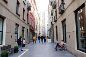
- Public administrations are responsible for ensuring that the transformation of the territory generates an accessible urban environment for all people.
Objectives for Accessibility in Planning
- The city should have good design of the environments and public and private spaces.
- High standards the quality and access to housing, the recovery of public spaces for pedestrians, and adapts to the new mobility needs.
- Focus on people by guaranteeing the equality of rights, personal autonomy, and respect for human diversity of all.
Premises
To achieve accessibility, the city requires the following:
- Balance between public and private spaces.
- Spaces designated for production, leisure, and consumption
- Coexistence with the past and future towards sustainable development.
Strategies to Incorporate in Existing or Consolidated Cities
- Encourage citizen participation to understand citizens' needs and meet them through precise planning instruments.
- Conduct studies to determine the degree of accessibility by neighborhood.
- Define an urban indicator for Universal accessibility to enable decision-making, investment, and prioritization of actions.
- Promote the availability and quality of public spaces by promoting open spaces.
- Encourage socialization while reinforcing the value of pedestrians and implement standards for the design and normalization of public space elements.
- Improve universal accessibility to buildings and their immediate environment.
- Encourage construction initiatives for accessible housing
- Guarantee accessible mobility and urban transport.
- Facilitate orientation, understanding, and communication in the city, organizing it to promote its use by all people.
Case Study: "Neighborhood Plans" Virgen de Begoña
- In 2011, actions in the VdB neighborhood began with work by the urban planners of Estudio "Paisaje Transversal."
- The team promoted and developed a participatory program with the Neighborhood Association to detect the needs of the neighborhood.
- This process was based on a "bottom-up" approach.
- The neighborhood, one of the open-block Madrid polygons, is surrounded by major infrastructure like the A-1 highway, M-30, and railroad tracks isolate the neighborhood.
- The area faces obsolescence of buildings, poor building quality, and vacant public spaces.
Analysis & Solutions for Virgen de Begoña
- Solutions involve analyzing the initial state of use and ownership of these spaces.
- The solutions propose a series of interventions for rehabilitation and activation and it’s based on collaborative design workshops.
- The workshops engage residents in analyzing and developing various proposals.
- One conclusion was the need to provide content to the inter-block spaces.
- There is a lack of intentionality in the design, generating unused spaces or deficiencies in accessibility that prevent established pedestrian routes.
PIER Virgen de Begoña (2015)
- In 2015, the Comprehensive Regeneration Strategy Plan (PIER) for the Virgen de Begoña neighborhood was drafted.
- This plan includes the methodology to develop participatory urban regeneration processes.
Indicators in Urban Regeneration Projects in Madrid
- The City Council is conducting studies to collect and analyze geodata for URBAN REGENERATION.
- The goal is to define indicators for the quantitative and qualitative diagnosis of the current state, opportunities, and needs of Madrid.
Strategies for New Cities or Residential Developments
- The starting point consists of acting from the origin in the design of the city.
- Incorporate guiding principles of universal accessibility and design for all people in urban planning.
- Apply a cross-cutting approach that directly improves the quality of urban life.
- Create the necessary structure to guarantee the autonomy, and access to, and utilization of facilities, commerce, open spaces, and local economic activities.
- Promote a fluid relationship between the environment and people by locating leisure areas, commercial spaces, and gardens near residential areas.
- Facilitate and promote social relationships in public spaces
- Prioritize roads and categorize open spaces, giving character to elements and indicating standards for design.
- Promote public transport adapted to real needs
- Provide for a reserve of accessible parking spaces.
Valdebebas: Accessibility Focus for Urban Framework
- Layout based on a grid pattern, with streets at right angles, creating regular blocks with diagonals to generate cross-functionality.
- The grid parcels mostly create blocks of 116 m.
- The mixed uses allow the combination of uses, avoiding low-activity zones, and the implantation of local commerce.
- The 116 m blocks are accompanied by green connectors at their extremes to provide pedestrian transport, ensuring that each home is at least 150 m from green space connected to the parks.
Valdebebas Street Hierarchy
The neighborhood included the following:
- Structuring, perimeter, primary, and secondary routes, and green connectors, marked by sidewalks.
- Paving follows criteria of use, textures, colors, differentiated patterns, creating paving codes.
- Paving codes and color contrast improve orientation and identification for the pedestrian.
- Paths, walkways, and roadways create pathways for people with reduced vision.
- Primary streets act as priority axes for pedestrians
- Pedestrian crossings maintain the same elevation between the sidewalk and road to ensure accessibility.
Valdebebas - Other Considerations
- All road surfaces used sound-absorbing pavements and exhibit durability, slip resistance, superficial drainage, and a slope of between 6% and 8%.
- Urban furniture includes benches and seating 50 to 100 m apart.
- The objective is to enhance pedestrian mobility with a 27km bike path, the integration of pedestrian areas, and an interchanger that connect the commuter rail.
Valdebebas
- Focuses on pedestrian-vehicle intersection zones, where walkways descend along the street and elevated roads are used to maintain an even elevation for pedestrians.
- Reserved spaces are designated for people with reduced mobility (PRM).
- Urban trees provide a landscape and sustainable function, and is a place that promote accessibility, well-being, and provide a welcoming shady respite.
- The city uses a code of plantations, in the green route where trees are planted in double alignment.
- The Green route in the Autumn feature red fruit, offering recognizable traits with it being the only tree in the lane.
Valdebebas - Walking Itineraries
- Longitudinal pedestrian itineraries contain an active and passive zone where the static zone contains urban elements and the active zone allows space.
- Transverse pedestrian itineraries includes designated slopes, street access based on the Community of Madrid's Accessibility Regulations.
Studying That Suits You
Use AI to generate personalized quizzes and flashcards to suit your learning preferences.