Podcast
Questions and Answers
What is the source of the Whangaehu River?
What is the source of the Whangaehu River?
- Crater Lake (correct)
- Mount Ruapehu's eastern slopes
- Whangaehu Valley
- Ruapehu's eruptions
What is the Whangaehu River notorious for?
What is the Whangaehu River notorious for?
- Flooding
- Its long length
- Its scenic beauty
- Destructive lahars caused by Ruapehu's eruptions (correct)
What happened to the dams built across the outlet on several occasions?
What happened to the dams built across the outlet on several occasions?
- They were never built
- They were always successful
- They failed in 1953 and 2007 (correct)
- They were built in 1862 and 1895
What is the name of the glacier that feeds the Whangaehu River?
What is the name of the glacier that feeds the Whangaehu River?
What is the Summit Plateau glacier?
What is the Summit Plateau glacier?
How many glaciers have been recognised on Ruapehu?
How many glaciers have been recognised on Ruapehu?
What is the Mangatoetoenui glacier one of the principal sources of?
What is the Mangatoetoenui glacier one of the principal sources of?
What type of climate does Ruapehu have on the upper slopes?
What type of climate does Ruapehu have on the upper slopes?
Where is Mount Ruapehu located?
Where is Mount Ruapehu located?
What is the highest point in the North Island?
What is the highest point in the North Island?
What is Crater Lake also known as?
What is Crater Lake also known as?
What is the approximate volume of Mount Ruapehu?
What is the approximate volume of Mount Ruapehu?
Which road leads to Whakapapa Village?
Which road leads to Whakapapa Village?
What is unique about the skifields on Mount Ruapehu?
What is unique about the skifields on Mount Ruapehu?
What is Mount Ruapehu known for?
What is Mount Ruapehu known for?
What is the meaning of the name Ruapehu?
What is the meaning of the name Ruapehu?
Flashcards are hidden until you start studying
Study Notes
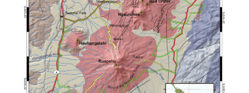
Location and Geography
- Mount Ruapehu is an active stratovolcano located in the North Island of New Zealand, within the Tongariro National Park.
- It is situated 23 km northeast of Ohakune and 23 km southwest of the southern shore of Lake Taupō.
Features and Peaks
- Mount Ruapehu has three major peaks: Tahurangi (2,797 m), Te Heuheu (2,755 m), and Paretetaitonga (2,751 m).
- It has a deep, active crater called Crater Lake (Te Wai ā-moe) that fills with water between major eruptions.
Ski Resorts and Access
- The North Island's major ski resorts are located on its slopes.
- There are three access routes to Ruapehu, leading to three skifields: Whakapapa, Turoa, and Tukino.
Crater Lake and Eruptions
- Crater Lake is situated at the southern end of the Summit Plateau and is filled with a warm, acidic lake.
- The lake's outlet is at the head of the Whangaehu Valley, where the Whangaehu River arises.
- Eruptions have built tephra dams across the outlet on several occasions, causing destructive lahars down the river.
Glaciers
- A total of 18 glaciers have been recognized on Ruapehu, with six named glaciers.
- Two glaciers are found in the active crater, and most of the ice on Ruapehu is contained in the Whangaehu, Summit Plateau, and Mangatoetoenui glaciers.
Climate
- Mount Ruapehu has a polar tundra climate (Köppen: ET) on the upper slopes.
- The glaciers are sensitive to changes in climate and have been thinning and retreating since 1955, with the exception of the northern crater glacier.
Studying That Suits You
Use AI to generate personalized quizzes and flashcards to suit your learning preferences.