Podcast
Questions and Answers
Which of the following best describes the relationship between infiltration and runoff in the context of a watershed?
Which of the following best describes the relationship between infiltration and runoff in the context of a watershed?
- Infiltration and runoff are independent processes that do not affect each other.
- Increased infiltration always leads to increased runoff due to saturated soil conditions.
- Decreased infiltration always leads to decreased runoff, as there is less water available.
- Increased infiltration generally leads to decreased runoff, as more water is absorbed into the soil. (correct)
A floodplain map typically delineates areas subject to flooding based on flood frequency analysis and hydraulic modeling. What is the primary purpose of these maps?
A floodplain map typically delineates areas subject to flooding based on flood frequency analysis and hydraulic modeling. What is the primary purpose of these maps?
- To guide land use planning, insurance requirements, and emergency management strategies. (correct)
- To control the flow of water in rivers and prevent all flooding.
- To provide real-time flood forecasts during storm events.
- To estimate the exact cost of damages from future flood events.
Which of the following factors would most likely lead to an underestimation of flood risk in a flood frequency analysis?
Which of the following factors would most likely lead to an underestimation of flood risk in a flood frequency analysis?
- Using a partial duration series instead of an annual flood series.
- Using a longer period of record for streamflow data.
- Assuming stationarity in the climate when it is actually changing, leading to more extreme events. (correct)
- Calibrating a physically based model with high resolution data.
How does urbanization typically impact the rainfall-runoff relationship in a watershed?
How does urbanization typically impact the rainfall-runoff relationship in a watershed?
What is the most significant difference between a 1D and a 2D hydraulic model in flood risk assessment?
What is the most significant difference between a 1D and a 2D hydraulic model in flood risk assessment?
Which of the following is the most accurate definition of a watershed?
Which of the following is the most accurate definition of a watershed?
What role does vegetation play in influencing hydrologic processes within a watershed?
What role does vegetation play in influencing hydrologic processes within a watershed?
Given a hydrograph, which of the following statements accurately describes the 'rising limb'?
Given a hydrograph, which of the following statements accurately describes the 'rising limb'?
Which of the following is a non-structural flood control measure?
Which of the following is a non-structural flood control measure?
Climate change can affect flood risk through several mechanisms. Which of the following is the most direct impact of sea level rise on coastal flood risk?
Climate change can affect flood risk through several mechanisms. Which of the following is the most direct impact of sea level rise on coastal flood risk?
Flashcards
Hydrologic Cycle
Hydrologic Cycle
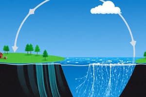
Continuous circulation of water between Earth's surface and atmosphere involving precipitation, infiltration, runoff, evaporation, and condensation.
Watershed
Watershed
Area of land that drains to a common outlet such as a river, lake, or ocean. Defined by topographic divides.
Hydrograph
Hydrograph
Graph showing rate of flow (discharge) versus time past a specific point in a river or channel.
Flood Frequency Analysis
Flood Frequency Analysis
Signup and view all the flashcards
Floodplain Mapping
Floodplain Mapping
Signup and view all the flashcards
Hydraulic Modeling
Hydraulic Modeling
Signup and view all the flashcards
Structural Flood Control
Structural Flood Control
Signup and view all the flashcards
Non-Structural Flood Control
Non-Structural Flood Control
Signup and view all the flashcards
Green Infrastructure
Green Infrastructure
Signup and view all the flashcards
Return Period
Return Period
Signup and view all the flashcards
Study Notes
- Hydrology is the study of water on Earth, including its distribution, movement, and properties.
- It encompasses the hydrologic cycle processes.
Hydrologic Cycle
- The hydrologic cycle is the continuous circulation of water between the Earth's surface and the atmosphere.
- Key processes include:
- Precipitation: Water falling from the atmosphere as rain, snow, sleet, or hail.
- Interception: Precipitation that is intercepted by vegetation before reaching the ground.
- Infiltration: The process by which water enters the soil.
- Percolation: The movement of water through the soil and underlying rock layers.
- Evaporation: The process by which water changes from a liquid to a gas.
- Transpiration: The release of water vapor from plants into the atmosphere.
- Sublimation: The process by which water changes from a solid (ice or snow) directly to a gas.
- Condensation: The process by which water vapor changes into a liquid.
- Runoff: Water that flows over the land surface.
- Storage: Water held in various reservoirs, such as oceans, lakes, groundwater, and ice caps.
- These processes are interconnected and driven by solar energy and gravity.
Factors Influencing Hydrologic Processes
- Climate: Temperature, precipitation patterns, and solar radiation affect evaporation, transpiration, and precipitation types.
- Geology: Soil type and subsurface geology influence infiltration, percolation, and groundwater flow.
- Topography: Slope and elevation affect surface runoff and water accumulation.
- Vegetation: Land cover affects interception, transpiration, and soil erosion.
- Human Activities: Urbanization, agriculture, and deforestation alter land cover, infiltration rates, and runoff patterns.
Watersheds
- A watershed, also known as a drainage basin, is an area of land that drains to a common outlet, such as a river, lake, or ocean.
- Watersheds are defined by topographic divides.
- Characteristics include:
- Size: The area of the watershed.
- Shape: Influences the time it takes for water to reach the outlet.
- Slope: Affects runoff velocity and erosion potential.
- Land Cover: Influences infiltration, runoff, and evapotranspiration.
- Soil Type: Affects infiltration capacity and water storage.
- Drainage Density: The total length of stream channels per unit area.
- Watersheds are fundamental units for managing water resources and assessing flood risk.
Rainfall-Runoff Modeling
- Rainfall-runoff models simulate the transformation of rainfall into runoff.
- Types of models:
- Empirical Models: Based on statistical relationships between rainfall and runoff data.
- Conceptual Models: Represent hydrological processes using simplified mathematical equations.
- Physically-Based Models: Simulate hydrological processes based on physical laws.
- Model selection depends on data availability, scale, and objectives.
Hydrographs
- A hydrograph is a graph showing the rate of flow (discharge) versus time past a specific point in a river, channel, or conduit carrying flow.
- Components:
- Rising Limb: The increasing portion of the hydrograph.
- Peak Flow: The maximum discharge.
- Recession Limb: The decreasing portion of the hydrograph.
- Hydrographs provide information about the timing and magnitude of runoff events.
Flood Risk Assessment
- Flood risk assessment involves identifying, analyzing, and evaluating flood hazards and their potential impacts.
- Key components:
- Hazard Assessment: Evaluating the probability and magnitude of flood events.
- Vulnerability Assessment: Identifying populations, infrastructure, and assets that are susceptible to flood damage.
- Risk Assessment: Combining hazard and vulnerability information to estimate potential losses.
Flood Frequency Analysis
- Flood frequency analysis estimates the probability of exceedance for flood events of different magnitudes.
- Common methods:
- Annual Flood Series: Using the maximum flood discharge for each year of record.
- Partial Duration Series: Using all flood events that exceed a threshold.
- Probability distributions such as Gumbel, Log-Pearson Type III, and Generalized Extreme Value (GEV) are used to fit the data.
- Return Period: The average interval between events of a given magnitude (e.g., a 100-year flood).
Floodplain Mapping
- Floodplain maps delineate areas that are subject to flooding based on flood frequency analysis and hydraulic modeling.
- Floodplains are typically defined for different return periods (e.g., 100-year and 500-year floodplains).
- Used for land use planning, insurance, and emergency management.
Hydraulic Modeling
- Hydraulic models simulate the flow of water in rivers and floodplains.
- Common models:
- One-Dimensional (1D) Models: Assume that flow is uniform across the channel cross-section.
- Two-Dimensional (2D) Models: Simulate flow patterns in both the horizontal and vertical dimensions.
- HEC-RAS: A widely used hydraulic modeling software developed by the U.S. Army Corps of Engineers.
- Hydraulic models are used to estimate water surface elevations, flow velocities, and inundation depths.
Flood Control Measures
- Structural Measures:
- Dams and Reservoirs: Store floodwater and release it gradually.
- Levees and Floodwalls: Confine floodwater to the river channel.
- Channel Modifications: Alter the shape and alignment of channels to increase flow capacity.
- Diversion Channels: Redirect floodwater away from vulnerable areas.
- Non-Structural Measures:
- Floodplain Zoning: Restricting development in flood-prone areas.
- Building Codes: Requiring flood-resistant construction.
- Flood Forecasting and Warning Systems: Providing timely warnings to allow for evacuation and preparedness.
- Flood Insurance: Providing financial protection for property owners.
- Public Awareness Campaigns: Educating the public about flood risks and preparedness measures.
Urban Hydrology
- Urbanization alters hydrologic processes.
- Increased Impervious Surfaces: Reduce infiltration and increase surface runoff.
- Storm Sewers: Rapidly convey runoff to streams, increasing peak flows.
- Reduced Evapotranspiration: Less vegetation cover reduces evapotranspiration.
- Management Strategies:
- Green Infrastructure: Using natural systems to manage stormwater (e.g., rain gardens, green roofs, permeable pavements).
- Detention Basins: Temporarily store stormwater and release it slowly.
- Infiltration Basins: Promote infiltration of stormwater into the ground.
Climate Change and Flood Risk
- Climate change is altering precipitation patterns and increasing the frequency and intensity of extreme weather events.
- Sea Level Rise: Increases the risk of coastal flooding.
- Increased Rainfall Intensity: Leads to higher peak flows and greater flood depths.
- Changes in Snowmelt: Affect the timing and magnitude of runoff.
- Adaptation Strategies:
- Strengthening infrastructure to withstand more extreme events.
- Implementing more stringent floodplain regulations.
- Developing more accurate flood forecasting systems.
- Restoring natural floodplain functions.
Uncertainty in Hydrologic Analysis
- Hydrologic analysis involves uncertainty due to:
- Data Limitations: Limited availability of rainfall, streamflow, and other data.
- Model Simplifications: Models are simplified representations of complex processes.
- Climate Variability: Natural variability in climate patterns.
- Addressing Uncertainty:
- Sensitivity Analysis: Evaluating how model outputs change in response to changes in input parameters.
- Ensemble Modeling: Running multiple models with different parameter sets to capture a range of possible outcomes.
- Risk-Based Decision Making: Considering the probabilities and consequences of different flood scenarios.
Studying That Suits You
Use AI to generate personalized quizzes and flashcards to suit your learning preferences.