Podcast
Play an AI-generated podcast conversation about this lesson
Download our mobile app to listen on the go
Get App
Questions and Answers
What does the term 'Location' refer to?
What does the term 'Location' refer to?
A specific place on the Earth
What is a Physical Map?
What is a Physical Map?
A map that shows natural landforms and waterways on the Earth's surface.
What does a Compass Rose represent on a map?
What does a Compass Rose represent on a map?
A symbol that shows directions on a map.
What is North on a Map?
What is North on a Map?
Signup and view all the answers
What does South on a Map refer to?
What does South on a Map refer to?
Signup and view all the answers
What does East on a Map indicate?
What does East on a Map indicate?
Signup and view all the answers
What does West on a Map signify?
What does West on a Map signify?
Signup and view all the answers
What is a Key on a Map?
What is a Key on a Map?
Signup and view all the answers
What does the Scale on a Map represent?
What does the Scale on a Map represent?
Signup and view all the answers
What is a Political Map?
What is a Political Map?
Signup and view all the answers
Flashcards are hidden until you start studying
Study Notes
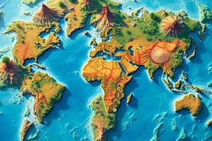
Map Components
- Location: Refers to a specific point on the Earth's surface, crucial for navigation and understanding geography.
- Physical Map: Illustrates natural features such as mountains, valleys, rivers, and other landforms, highlighting the Earth's physical landscape.
- Compass Rose: A navigational symbol that indicates the cardinal directions (North, South, East, West) on a map, essential for orientation.
Direction Indicators
- North on a Map: Represents geographic North, fundamental for orienting maps properly.
- South on a Map: Identified as Upper Egypt in this context, indicating geographical positioning in relation to the equator.
- East on a Map: New York is located in the Eastern part of the United States, exemplifying how directional orientation helps identify locations.
- West on a Map: California is situated in the Western part of the United States, illustrating the division of the country by direction.
Map Features
- Key on a Map: Also known as the legend, it lists symbols used on the map and explains their meanings, aiding in map interpretation.
- Scale on a Map: Represents the relationship between distances on the map and actual distances on Earth, crucial for understanding spatial relations.
- Political Map: Displays boundaries of countries and political units, providing insight into geopolitical divisions across the globe.
Studying That Suits You
Use AI to generate personalized quizzes and flashcards to suit your learning preferences.