Podcast
Questions and Answers
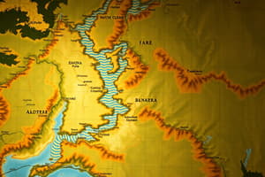
What do physical maps typically represent?
What do physical maps typically represent?
- Political boundaries and cities
- Transportation networks and infrastructure
- Landforms and bodies of water (correct)
- Cultural regions and demographics
Which of the following elements are found on political maps?
Which of the following elements are found on political maps?
- Topographical features and climate information
- Natural resources and wildlife habitats
- Population density and economic statistics
- Boundaries, regions, and capital cities (correct)
Which type of map would you use to find rivers and mountains?
Which type of map would you use to find rivers and mountains?
- Physical map (correct)
- Thematic map
- Cadastral map
- Political map
What characteristic distinguishes political maps from physical maps?
What characteristic distinguishes political maps from physical maps?
Which of the following statements is true concerning landforms and political maps?
Which of the following statements is true concerning landforms and political maps?
Which map would you use to find the capital cities of a country?
Which map would you use to find the capital cities of a country?
The compass rose illustrates the natural resources found in a region.
The compass rose illustrates the natural resources found in a region.
What term describes the study of map-making?
What term describes the study of map-making?
A map key is used to explain the ______ on a map.
A map key is used to explain the ______ on a map.
Match the following type of maps with their respective features:
Match the following type of maps with their respective features:
Flashcards are hidden until you start studying
Study Notes
Types of Maps
- Physical Maps depict landforms and water bodies, providing a visual representation of geographic features.
- Political Maps illustrate boundaries, regions, and capital cities, helping to identify governmental divisions.
- Climate Maps present long-term weather patterns of specific areas or regions, indicating climate zones.
- Economic Resources Maps reveal land use and natural resources in a region, highlighting economic activities.
- Population Density Maps showcase the number of people living in a defined area, important for demographic studies.
Key Map Elements
- Elevation refers to the height of land above sea level, crucial for understanding topography.
- Climate represents long-term weather conditions, differentiating climates like Humid Subtropical.
- Map Key explains the symbols and colors used on a map, enabling better interpretation.
- Compass Rose indicates directions (North, South, East, West) essential for navigation.
Additional Cartographic Concepts
- Topography displays the surface features of land, both artificial (like roads) and natural (like mountains).
- Cartography is the scientific study and practice of creating maps and understanding spatial relationships.
- A Cartographer is a professional who designs and produces maps, ensuring accuracy and clarity.
Examples of Specific Maps
- The Rocky Mountains are represented on Physical Maps, highlighting significant mountain ranges.
- An apple symbol is used on Economic Resources Maps to indicate locations of agricultural production, such as apple farms.
- A Population Density Map may illustrate regions with high populations, such as those with 2000 people per square mile.
- The capital of the United States is featured on Political Maps, marking important national landmarks.
Studying That Suits You
Use AI to generate personalized quizzes and flashcards to suit your learning preferences.