Podcast
Questions and Answers
What key feature distinguishes topographic maps from other types of maps?
What key feature distinguishes topographic maps from other types of maps?
- They provide satellite imagery of areas.
- They show physical features using contour lines. (correct)
- They illustrate transport routes for navigation.
- They depict only political boundaries.
Which type of map would be most useful for understanding the distribution of natural resources in an area?
Which type of map would be most useful for understanding the distribution of natural resources in an area?
- Data and resource maps (correct)
- Political maps
- Road maps
- Physical maps
Which type of map primarily focuses on human-made features like boundaries and cities?
Which type of map primarily focuses on human-made features like boundaries and cities?
- Physical maps
- Topographic maps
- Satellite maps
- Political maps (correct)
What aspect is typically highlighted in physical maps?
What aspect is typically highlighted in physical maps?
Which type of map is primarily utilized for navigation by drivers?
Which type of map is primarily utilized for navigation by drivers?
What is the primary purpose of contour lines on a map?
What is the primary purpose of contour lines on a map?
Which type of map would you refer to for understanding population distribution in a region?
Which type of map would you refer to for understanding population distribution in a region?
What do grid references on a map help to identify?
What do grid references on a map help to identify?
What is a key characteristic of a physical map?
What is a key characteristic of a physical map?
What aspect differentiates a climate map from a topographic map?
What aspect differentiates a climate map from a topographic map?
Which statement correctly defines the cardinal points?
Which statement correctly defines the cardinal points?
Which type of map would best reveal historic features or events from the past?
Which type of map would best reveal historic features or events from the past?
What is the significance of a map's scale?
What is the significance of a map's scale?
Flashcards
What are Physical Maps?
What are Physical Maps?
These maps show the physical characteristics of land and water in a particular area. They detail features like mountains, rivers, and deserts.
What are Political Maps?
What are Political Maps?
These maps display features created by governments. Examples include national boundaries, capital cities, and towns.
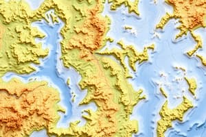
What are Topographic Maps?
What are Topographic Maps?
These maps are detailed and show both physical and political features. They are known for using contour lines that show the height of the land above sea level.
What are Road Maps?
What are Road Maps?
Signup and view all the flashcards
What are Data and Resource Maps?
What are Data and Resource Maps?
Signup and view all the flashcards
What is geography?
What is geography?
Signup and view all the flashcards
What are map symbols?
What are map symbols?
Signup and view all the flashcards
What is map scale?
What is map scale?
Signup and view all the flashcards
What are contour lines?
What are contour lines?
Signup and view all the flashcards
What is contour interval?
What is contour interval?
Signup and view all the flashcards
What is a grid reference?
What is a grid reference?
Signup and view all the flashcards
What is a political map?
What is a political map?
Signup and view all the flashcards
What is a physical map?
What is a physical map?
Signup and view all the flashcards