Podcast
Questions and Answers
The Geography of Poverty, a project by Matt Black, serves as a ______ document reflecting significant economic divisions in the United States.
The Geography of Poverty, a project by Matt Black, serves as a ______ document reflecting significant economic divisions in the United States.
singular
More than ______ years after LBJ's 'War on Poverty,' a substantial portion of the U.S. population continues to live below the poverty line, despite the nation's wealth.
More than ______ years after LBJ's 'War on Poverty,' a substantial portion of the U.S. population continues to live below the poverty line, despite the nation's wealth.
fifty
Matt Black's photographic journey covered over 100,000 miles, documenting poverty areas across 46 states from the Southwest deserts to the industrial towns of the Midwest and ______.
Matt Black's photographic journey covered over 100,000 miles, documenting poverty areas across 46 states from the Southwest deserts to the industrial towns of the Midwest and ______.
Northeast
The project utilized interactive data ______ and geotagged maps, enhancing the audience's engagement with poverty statistics and the photographer’s journey.
The project utilized interactive data ______ and geotagged maps, enhancing the audience's engagement with poverty statistics and the photographer’s journey.
The adaptation of Matt Black's work into a ______ microsite allowed for a deep dive into the issues, combining photography, video clips, and interactive data.
The adaptation of Matt Black's work into a ______ microsite allowed for a deep dive into the issues, combining photography, video clips, and interactive data.
A key element of the project’s digital presence was the real-time connection with the audience via ______, enabling followers to witness the journey and engage with the photographer's ongoing work.
A key element of the project’s digital presence was the real-time connection with the audience via ______, enabling followers to witness the journey and engage with the photographer's ongoing work.
The success of the Geography of Poverty project hinged on a ______ effort, involving various teams that contributed to its development and execution.
The success of the Geography of Poverty project hinged on a ______ effort, involving various teams that contributed to its development and execution.
One outcome of the project's visual storytelling was its ability to ______ facts and numbers, making the issue of poverty more relatable and understandable.
One outcome of the project's visual storytelling was its ability to ______ facts and numbers, making the issue of poverty more relatable and understandable.
In addition to the digital microsite, a special edition ______ zine was produced, further extending the project's reach and impact through a tangible medium.
In addition to the digital microsite, a special edition ______ zine was produced, further extending the project's reach and impact through a tangible medium.
The executive producer played a pivotal role in persuading executives to invest in a ______ microsite, tailored specifically for the project's storytelling needs.
The executive producer played a pivotal role in persuading executives to invest in a ______ microsite, tailored specifically for the project's storytelling needs.
Establishing a robust ______ for the long-form narrative required close collaboration between the executive producer, photographer, and writer, to ensure a cohesive and impactful presentation.
Establishing a robust ______ for the long-form narrative required close collaboration between the executive producer, photographer, and writer, to ensure a cohesive and impactful presentation.
Securing additional ______ and managing partnerships with organizations such as the Magnum Foundation and the Pulitzer Center were crucial for supporting the project's scope and depth.
Securing additional ______ and managing partnerships with organizations such as the Magnum Foundation and the Pulitzer Center were crucial for supporting the project's scope and depth.
Directing and editing all aspects of the ______ content, including photographs and video, ensured a consistent aesthetic and narrative throughout the project.
Directing and editing all aspects of the ______ content, including photographs and video, ensured a consistent aesthetic and narrative throughout the project.
Creating a comprehensive ______ media campaign was essential for building and maintaining an audience, leveraging multiple platforms to promote the project's message and engage with viewers.
Creating a comprehensive ______ media campaign was essential for building and maintaining an audience, leveraging multiple platforms to promote the project's message and engage with viewers.
The project's use of geotagged maps integrated with poverty statistics and photographs transformed a country-wide issue into a readily comprehensible, spatially ______ problem.
The project's use of geotagged maps integrated with poverty statistics and photographs transformed a country-wide issue into a readily comprehensible, spatially ______ problem.
Flashcards
Geography of Poverty
Geography of Poverty
A project documenting poverty areas in the US through photography and data.
Poverty Areas
Poverty Areas
Areas with poverty rates exceeding 20%.
Matt Black
Matt Black
The photographer for the Geography of Poverty project.
Amy Pereira
Amy Pereira
Signup and view all the flashcards
Microsite
Microsite
Signup and view all the flashcards
Photography's role
Photography's role
Signup and view all the flashcards
Spotlight effect
Spotlight effect
Signup and view all the flashcards
Trymaine Lee
Trymaine Lee
Signup and view all the flashcards
Study Notes
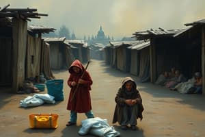
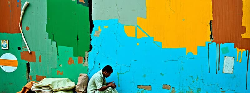
- Magnum photographer Matt Black traveled over 100,000 miles across 46 states, documenting poverty areas.
- The project profiles marginalized people and communities in the U.S.
- "The Geography of Poverty" is a document of unprecedented economic divisions in the United States.
- Over 43 million people in the U.S. live below the poverty line.
- Income inequality has increased, with the top 1% and 0.1% holding a growing share of national wealth since the 1970s.
- Black documented communities with poverty rates exceeding 20%.
- A long-form microsite was created to showcase Black's project, featuring photography, motion clips, data visualization, and geotagged maps.
- The microsite allowed audiences to follow Black's journey in real-time via his Instagram and provided data points and poverty statistics.
- Photography can help to humanize facts and numbers related to poverty.
- The map emphasizes the scale of poverty, while individual stories highlight the country-wide issue.
- Geography of Poverty Zine was published as a special edition print.
Studying That Suits You
Use AI to generate personalized quizzes and flashcards to suit your learning preferences.