Podcast
Questions and Answers
What impact do the Himalayas have on the climate and geography of southwest China and northwest India?
What impact do the Himalayas have on the climate and geography of southwest China and northwest India?
- They evenly distribute rainfall, ensuring uniform agricultural productivity across the region.
- They block all monsoonal winds, causing widespread drought.
- They trap rain clouds on the Indian side, fostering rainforests and grasslands, while creating drier conditions on the Chinese side. (correct)
- They create a rain shadow effect, leading to desertification on both sides of the mountain range.
Why is the Tibetan Plateau referred to as the "roof of the world?"
Why is the Tibetan Plateau referred to as the "roof of the world?"
- It is the world's highest plateau, with elevations averaging 14,800 feet above sea level. (correct)
- It is the most densely populated area in the world.
- It houses a large number of hydroelectric power plants.
- It experiences extremely mild summers and winters.
Which factor most significantly limits human settlement in the Gobi Desert?
Which factor most significantly limits human settlement in the Gobi Desert?
- Proximity to major urban centers
- Extreme temperatures and lack of water (correct)
- Abundant water resources
- Fertile soil suitable for agriculture
How does the Yangtze River contribute to China's economy and agriculture?
How does the Yangtze River contribute to China's economy and agriculture?
Why is the Ganges River considered one of the most important rivers in the Indian subcontinent?
Why is the Ganges River considered one of the most important rivers in the Indian subcontinent?
How do the long coastlines of many Asian countries impact their economic activities?
How do the long coastlines of many Asian countries impact their economic activities?
Which combination of factors explains the low population density of the Tibetan Plateau?
Which combination of factors explains the low population density of the Tibetan Plateau?
What challenges does the Taklimakan Desert present to economic development, despite the discovery of oil?
What challenges does the Taklimakan Desert present to economic development, despite the discovery of oil?
Which statement accurately describes the influence of the Himalayas on India's climate?
Which statement accurately describes the influence of the Himalayas on India's climate?
How do rivers in Southern and Eastern Asia support high population densities?
How do rivers in Southern and Eastern Asia support high population densities?
What difference in climate exists between the northern and southern regions of Asia?
What difference in climate exists between the northern and southern regions of Asia?
What has been built on glaciers throughout the Himalayan Mountains to supply energy throughout the region?
What has been built on glaciers throughout the Himalayan Mountains to supply energy throughout the region?
What makes the Chinese side of the Himalayas different from the Indian side?
What makes the Chinese side of the Himalayas different from the Indian side?
What economic activity is possible on the Tibetan Plateau during the warmer months?
What economic activity is possible on the Tibetan Plateau during the warmer months?
Which characteristic defines the southern portion of the Gobi Desert?
Which characteristic defines the southern portion of the Gobi Desert?
What mode of transportation do inhabitants of the Gobi Desert commonly use?
What mode of transportation do inhabitants of the Gobi Desert commonly use?
Why is it nearly impossible for people to get to work locations in the Taklimakan Desert, despite the discovery of oil?
Why is it nearly impossible for people to get to work locations in the Taklimakan Desert, despite the discovery of oil?
What resources do rivers in Southern and Eastern Asia provide to people?
What resources do rivers in Southern and Eastern Asia provide to people?
What is located in the Huang He River basin?
What is located in the Huang He River basin?
What natural process keeps the region's soil fertile along the Yangtze River?
What natural process keeps the region's soil fertile along the Yangtze River?
Which religious tradition is the Ganges River most closely associated with?
Which religious tradition is the Ganges River most closely associated with?
What physical feature separates India from the rest of Asia on three sides?
What physical feature separates India from the rest of Asia on three sides?
How do the Himalayas affect the distribution of vegetation in the region?
How do the Himalayas affect the distribution of vegetation in the region?
What nickname has been given to the Tibetan Plateau due to its geographical characteristics?
What nickname has been given to the Tibetan Plateau due to its geographical characteristics?
In what region of Asia is the Gobi Desert found?
In what region of Asia is the Gobi Desert found?
Besides its limited rainfall, what is another significant characteristic of the Taklimakan Desert that affects its habitability?
Besides its limited rainfall, what is another significant characteristic of the Taklimakan Desert that affects its habitability?
The Huang He River is crucial for transportation. Which statement accurately describes this role?
The Huang He River is crucial for transportation. Which statement accurately describes this role?
How does the annual flooding of the Yangtze River affect agricultural practices in the region?
How does the annual flooding of the Yangtze River affect agricultural practices in the region?
Besides water, what crucial role does the Ganges River fill for people in India?
Besides water, what crucial role does the Ganges River fill for people in India?
The text mentions coastal industries of Southern and Eastern Asia. Which of the following relies the MOST on the water for resources?
The text mentions coastal industries of Southern and Eastern Asia. Which of the following relies the MOST on the water for resources?
How does elevation contribute to the Tibetan Plateau's climate?
How does elevation contribute to the Tibetan Plateau's climate?
What do small nomadic populations of the Gobi Desert travel with in search of?
What do small nomadic populations of the Gobi Desert travel with in search of?
Why can the Yangtze River be considered a large trading location?
Why can the Yangtze River be considered a large trading location?
What is a key characteristic that distinguishes the Taklimakan Desert from other deserts?
What is a key characteristic that distinguishes the Taklimakan Desert from other deserts?
What geographic feature contributes to the heavy population density in the Ganges River basin?
What geographic feature contributes to the heavy population density in the Ganges River basin?
In addition to Yangtze, what is another major river, with high population density, in China?
In addition to Yangtze, what is another major river, with high population density, in China?
Because of the extreme conditions on the Tibetan Plateau, what is the poplulation density?
Because of the extreme conditions on the Tibetan Plateau, what is the poplulation density?
What is the climate like for the Gobi Desert?
What is the climate like for the Gobi Desert?
What is unique about the Himalayan's impact on the division of China and India?
What is unique about the Himalayan's impact on the division of China and India?
How does annual flooding impact the Yangtze River?
How does annual flooding impact the Yangtze River?
Flashcards
Himalayas
Himalayas
The Himalayas are a mountain range with some of the tallest peaks.
India's separation
India's separation
The Himalayas separate India from the rest of Asia by mountain ranges.
Himalayas' impact
Himalayas' impact
The high mountains trap rain clouds, so rainforests and grasslands can be found.
Tibetan Plateau
Tibetan Plateau
Signup and view all the flashcards
Tibetan Plateau Climate
Tibetan Plateau Climate
Signup and view all the flashcards
Gobi Desert
Gobi Desert
Signup and view all the flashcards
Gobi Desert Conditions
Gobi Desert Conditions
Signup and view all the flashcards
Gobi Desert Population
Gobi Desert Population
Signup and view all the flashcards
Taklimakan Desert
Taklimakan Desert
Signup and view all the flashcards
Importance of Rivers
Importance of Rivers
Signup and view all the flashcards
Huang He River
Huang He River
Signup and view all the flashcards
Yangtze River
Yangtze River
Signup and view all the flashcards
Result of the Yangtze
Result of the Yangtze
Signup and view all the flashcards
The Purpose of the Yangtze River
The Purpose of the Yangtze River
Signup and view all the flashcards
Ganges River Origin
Ganges River Origin
Signup and view all the flashcards
How populated it it?
How populated it it?
Signup and view all the flashcards
The religious name of the Ganges
The religious name of the Ganges
Signup and view all the flashcards
Ganges River Importance
Ganges River Importance
Signup and view all the flashcards
How do they use the Ganges River?
How do they use the Ganges River?
Signup and view all the flashcards
Study Notes
- Southern & Eastern Asia have diverse mountain, desert, and water features.
- Icy mountain ranges are located in the North.
- Steamy rainforests lie in the South
- A large part of Asia is desert.
- Southern and Eastern Asia receives massive amounts of rain each year
- These features impact trade and affect the region.
Impact of Mountains
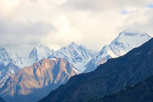
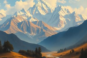
- The Himalayas are a mountain range with some of the tallest peaks in the world.
- The Himalayas have a significant impact on life in southwest China and northwest India.
- Hydroelectric power plants have been built on glaciers throughout the Himalayas, which supplies energy throughout the region.
- India is separated from the rest of Asia on three sides by mountain ranges.
- The high mountains trap rain clouds on India's side of the Himalayas, so rainforests and grasslands can be found.
- The Chinese side of the icy Himalayas receives very little.
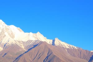
Tibetan Plateau
- The Tibetan Plateau covers the majority of western China.
- The Tibetan Plateau is the world's highest plateau at 14,800 feet above sea level
- The Tibetan Plateau is nicknamed "the roof of the world" due to the region's extremely high elevations.
- Many of Asia's major rivers begin in the Tibetan Plateau.
- The rivers are fed by more than 30,000 glaciers that are located on the plateau.
- In this region, summers are short and winters are long and extremely cold.
- During the few warmer months, farmers can let livestock graze in the region's grasslands.
- Overall, this region has a low population density of only two persons per square mile.
Impact of Deserts
- The Gobi Desert is located in northern China.
- The Gobi Desert is Asia's largest desert.
- The region is extremely dry.
- The southern portion of the Gobi Desert is completely waterless.
- The Gobi is known for its extreme temperatures with winter lows of -40°F and summer highs above 100°F.
- Some mining is done in the Gobi Desert, but it is not enough to support large cities.
- The small nomadic population of the Gobi travels with its herds of small livestock looking for oases.
- Inhabitants use camels to travel through the desert.
- The unforgiving Taklimakan Desert is one of the sandiest places in the world.
- It lacks adequate rainfall or other water sources.
- Like the Gobi, the Taklimakan Desert also has extreme temperatures that vary across the region.
- Oil has been discovered in the Taklimakan.
- Shifting sand dunes make it nearly impossible for people to get to work locations.
- Few people other than small nomadic groups inhabit the region.
Impact of Water
- Many Asian countries have long coastlines.
- Millions of people live along the ocean.
- Southern and Eastern Asia have large port cities
- Fishing, ship repair, and ship building are important industries that provide numerous jobs.
- Millions of people throughout Southern and Eastern Asia live near rivers.
- These water sources provide them with water for drinking and irrigating their crops.
Huang He
- The Huang He River basin is located in northern China.
- This area is home to more than 100 million people.
- The Huang He River valley receives an abundance of rainfall.
- The land is flat and fertile.
- The river allows ships to transport people and goods throughout the region.
Yangtze
- The Yangtze River is China's longest river.
- It is located in southeast China.
- The Yangtze River basin receives significant rainfall that flows into the river.
- Flooding of the Yangtze River keeps the region's soil fertile.
- Approximately 25% of China's farmland is located in the Yangtze River basin.
- The Yangtze River allows ships to transport people and goods from around the world to China's inland cities.
- Many of China's cities are located along the Yangtze River.
- Shanghai, with a population of 22 million people, is located here.
Ganges
- The Ganges River starts on a glacier high in the Himalayan Mountains.
- The Ganges winds 1500 miles through India and Bangladesh.
- It is the most highly populated river basin in the world, with over 1,000 people per square mile.
- The river is considered sacred by the Hindu religion.
- It is worshipped as the goddess Ganga.
- The Ganges River is the most important river in the Indian subcontinent.
- Indians use the Ganges for irrigation, drinking water, fishing, and for manufacturing needs.
- Ships carry agricultural goods down the Ganges River.
- Delhi, one of India's most populated cities with 11 million people, is located along the Ganges.
Studying That Suits You
Use AI to generate personalized quizzes and flashcards to suit your learning preferences.