Podcast
Questions and Answers
What is the name of the mountain range located in the Bay of Bengal?
What is the name of the mountain range located in the Bay of Bengal?
- Sumatra
- Malay Peninsula
- Barisan
- Bilauktaung Range (correct)
What is the largest desert in Asia?
What is the largest desert in Asia?
Gobi Desert
Which river is located under the Xi River?
Which river is located under the Xi River?
Red River
What is the second river off of the Chang Jian River?
What is the second river off of the Chang Jian River?
What body of water is known as the sea on the left?
What body of water is known as the sea on the left?
What is the name of the body of water that is significant to Korea?
What is the name of the body of water that is significant to Korea?
What ocean is identified as the 5th largest?
What ocean is identified as the 5th largest?
Which river is known to be between the Irrawaddy and Mekong rivers?
Which river is known to be between the Irrawaddy and Mekong rivers?
What is the name of the range located in Indonesia?
What is the name of the range located in Indonesia?
Which sea is located east of China?
Which sea is located east of China?
What is the name of the sea located between Vietnam and the Philippines?
What is the name of the sea located between Vietnam and the Philippines?
Flashcards are hidden until you start studying
Study Notes
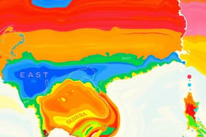
Southeast Asia Physical Geography
- Plateau of Tibet: High elevation area located in Central Asia, acting as a significant climatic influence for surrounding regions.
- Gobi Desert: Vast arid region covering parts of northern China and southern Mongolia, known for its harsh climate and unique ecosystems.
- Chang Jian River (Yangtze River): The longest river in China, flowing through central China, critical for transportation and agriculture.
- Huang He River (Yellow River): The second longest river in China, known as the cradle of Chinese civilization, historically significant for agriculture.
- Xiang River: A tributary of the Chang Jian River, crucial for regional irrigation and transportation.
- Gan River: The second major tributary flowing into the Chang Jian River, serving as an important waterway in Jiangxi province.
- Korea Bay: Marginal sea located between the Korean Peninsula and China's Shandong Peninsula, significant for fishing and shipping routes.
- Yellow Sea: Body of water between China and Korea, connecting the Bohai Sea to the east and noted for its fisheries and shipping lanes.
- East China Sea: Sea located east of China, known for its economic importance in terms of fishing, oil, and shipping routes.
- Pacific Ocean: The largest ocean, covering much of the eastern side of Asia, vital for international trade and marine biodiversity.
- Philippine Sea: Oceanic region to the east of the Philippines, part of the western Pacific with significant marine ecosystems.
- Korean Peninsula: Geographical region separated into North and South Korea, surrounded by the Yellow Sea, East Sea, and Korea Bay.
- Sea of Japan: Body of water between Japan and the Asian continent, known for its rich marine life and fishing industries.
- Borneo: The third-largest island in the world, located in Southeast Asia, home to diverse ecosystems and rich biodiversity.
- Java Sea: A sea located between the islands of Borneo and Java, crucial for regional trade and marine activities.
- Sumatra: Large Indonesian island known for its biodiversity, including tropical rainforests and volcanic activity.
- Indian Ocean: The third-largest ocean, bordered by Southeast Asia, it plays a significant role in climate and global trade.
- South China Sea: A critical maritime area for trade routes, rich in marine resources, and a center for regional geopolitical tensions.
- Gulf of Thailand: An arm of the South China Sea located to the southwest of Vietnam, important for fisheries and tourism.
- Bay of Bengal: Northeastern part of the Indian Ocean, bordered by India, Bangladesh, Myanmar; known for cyclones and rich fisheries.
- Flores Sea: Located to the left of the Indonesian archipelago, known for its biodiversity and marine life.
- Xi River: A significant river in southern China, contributing to the Pearl River system and important for transportation.
- Red River: A river flowing through northern Vietnam and southern China, vital for agriculture and transport.
- Mekong River: One of the longest rivers in Southeast Asia, flowing through several countries, essential for ecosystems and human use.
- Salween River: A river running between Myanmar and Thailand, serves as a crucial waterway and supports local biodiversity.
- Irrawaddy River: Major river in Myanmar, vital for transport, fishing, and irrigation.
- Gulf of Tonkin: A body of water located north of Vietnam, significant for shipping and fishing industries.
- Bilauktaung Range: Mountain range in the Bay of Bengal region, contributing to local ecology and climate patterns.
- Malay Peninsula: A region including parts of Thailand and Malaysia, known for its tropical rainforest and diverse wildlife.
- Barisan Range: Mountain range in Indonesia, extending along the western side of Sumatra, featuring volcanic activity and diverse ecosystems.
- Chao Phraya River: Major river flowing through Thailand, essential for agriculture, transport, and water supply in the region.
Studying That Suits You
Use AI to generate personalized quizzes and flashcards to suit your learning preferences.