Podcast
Questions and Answers
What revolutionized our understanding of the world beneath the waves?
What revolutionized our understanding of the world beneath the waves?
- Traditional fishing boats
- Satellite Remote Sensing Technology (SST) (correct)
- Scuba diving expeditions
- Underwater drones
When did scientists start exploring the potential of SST for oceanographic research?
When did scientists start exploring the potential of SST for oceanographic research?
- 1990s
- 1950s
- 2000s
- 1970s (correct)
What was the name of the first oceanographic satellite launched in 1978?
What was the name of the first oceanographic satellite launched in 1978?
- Skylink
- Oceaneye
- Waterwatch
- Seasat (correct)
What do sensors mounted on satellites detect in the ocean?
What do sensors mounted on satellites detect in the ocean?
What does SST help scientists understand about ocean dynamics?
What does SST help scientists understand about ocean dynamics?
What crucial role does SST play in ocean exploration?
What crucial role does SST play in ocean exploration?
What is the primary advantage of using satellite sensors for sea exploration?
What is the primary advantage of using satellite sensors for sea exploration?
How do satellite sensors compare to traditional in-situ sampling methods in terms of cost?
How do satellite sensors compare to traditional in-situ sampling methods in terms of cost?
What limitation do satellite sensors face in detecting features in sea exploration?
What limitation do satellite sensors face in detecting features in sea exploration?
What role does sea-surface temperature (SST) play in estimating phytoplankton biomass?
What role does sea-surface temperature (SST) play in estimating phytoplankton biomass?
Why is it important to monitor chlorophyll concentration in the ocean?
Why is it important to monitor chlorophyll concentration in the ocean?
Which statement best describes the data processing requirements of sea-surface temperature (SST) sensors?
Which statement best describes the data processing requirements of sea-surface temperature (SST) sensors?
Flashcards are hidden until you start studying
Study Notes
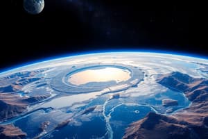
Exploring the Seas with Satellite Remote Sensing (SST)
Satellite Remote Sensing Technology (SST) has revolutionized our understanding of our planet's oceans, offering a bird's-eye view of the vast and diverse world beneath the waves. In this article, we'll delve into the history of SST, its applications in sea exploration, and how it's shaping our understanding of Earth's marine ecosystems.
Origins of SST for Sea Exploration
Remote Sensing from space began with the launch of the first satellite, Sputnik 1, in 1957. Initially, applications focused on Earth's landmasses, but by the 1970s, scientists started exploring the potential of SST for oceanographic research. The first oceanographic satellite, Seasat, was launched in 1978.
SST relies on the collection of data from sensors mounted on satellites orbiting Earth. These sensors detect various aspects of the ocean, such as water temperature, color, and surface elevation. This data is then transmitted back to Earth, where it's analyzed and used to generate maps and other visualizations that help scientists understand ocean dynamics and the marine environment.
Applications of SST in Sea Exploration
SST plays a crucial role in ocean exploration through various applications:
-
Mapping Oceans: SST generates high-resolution maps of ocean surfaces, highlighting features such as eddies, currents, and fronts, which help scientists better understand ocean circulation, mixing, and climate dynamics.
-
Temperature Measurements: Satellite sensors provide temperature data at the ocean surface, which is essential for understanding sea-surface temperature patterns and their relationship to weather and climate.
-
Biomass Estimations: SST can be used to estimate phytoplankton biomass, a primary producer in the marine ecosystem, which plays a significant role in the global carbon cycle.
-
Monitoring Ocean Colors and Chlorophyll: SST sensors detect the color of the ocean, which can be used to estimate the concentration of chlorophyll, a pigment found in phytoplankton. This information helps scientists monitor phytoplankton abundance and distribution, which is crucial for understanding marine food webs and predicting ocean productivity.
-
Monitoring Ocean Ice: SST sensors can be used to monitor the extent and thickness of sea ice, which is essential for understanding the Arctic and Antarctic ecosystems and predicting their response to climate change.
-
Monitoring Coastal Erosion: SST data can be used to monitor coastal erosion and the rate of change in coastal ecosystems, which is crucial for managing and conserving marine resources.
Advantages and Disadvantages of SST for Sea Exploration
SST offers several advantages for sea exploration:
- Global Coverage: SST provides global coverage of the oceans, allowing scientists to study the entire planet's marine ecosystem.
- Cost-effectiveness: SST is more cost-effective than traditional in-situ sampling methods, such as ship-based measurements.
- Frequent Observations: SST can be used to monitor ocean conditions in near-real-time, allowing scientists to track short-term changes and phenomena.
However, SST also has limitations:
- Shallow Water Limitations: SST sensors cannot detect features in shallow waters, such as seagrass beds and coral reefs, which are crucial for understanding coastal ecosystem dynamics.
- Resolution Limitations: SST sensors have limited resolution, which can make it difficult to study small-scale ocean features and processes.
- Data Processing Complexity: SST data requires specialized processing techniques to generate meaningful and accurate information.
Conclusion
Satellite Remote Sensing has revolutionized our understanding of the oceans, providing a global perspective of the marine environment, and offering a cost-effective and frequent means of monitoring ocean dynamics, biology, and weather. However, SST also has limitations, and researchers continue to develop new techniques and technologies to improve the resolution and accuracy of SST data. By combining SST data with other sources of information, scientists can continue to advance our understanding of the oceans and their role in Earth's ecosystems.
References:
Studying That Suits You
Use AI to generate personalized quizzes and flashcards to suit your learning preferences.