Podcast
Questions and Answers
What is the primary advantage of remote sensing in providing a regional view?
What is the primary advantage of remote sensing in providing a regional view?
- It enables the detection of subtle changes in the environment
- It facilitates the collection of data over large areas (correct)
- It allows for a more detailed view of a specific area
- It provides a more accurate view of the Earth's surface
Which of the following professionals is most likely to use remote sensing for mineral prospecting?
Which of the following professionals is most likely to use remote sensing for mineral prospecting?
- Geologist (correct)
- Forester
- Environmentalists
- Geographer
What is the primary advantage of remote sensing in disastrous situations?
What is the primary advantage of remote sensing in disastrous situations?
- It allows for a rapid response to emergency situations (correct)
- It facilitates the collection of data over large areas
- It enables the detection of subtle changes in the environment
- It provides a more accurate view of the Earth's surface
Which of the following is NOT a application of remote sensing?
Which of the following is NOT a application of remote sensing?
What is the primary reason why remote sensors are useful in all weather conditions?
What is the primary reason why remote sensors are useful in all weather conditions?
What is the primary application of photogeology in geological studies?
What is the primary application of photogeology in geological studies?
What is the difference between passive and active remote sensing systems?
What is the difference between passive and active remote sensing systems?
What is the primary purpose of structural mapping in geological applications?
What is the primary purpose of structural mapping in geological applications?
What is the role of the atmosphere in the remote sensing process?
What is the role of the atmosphere in the remote sensing process?
Which of the following is an example of an active remote sensing system?
Which of the following is an example of an active remote sensing system?
Study Notes
Remote Sensing: Definition
- Remote sensing is the science of measurement from a distance, obtaining information about an object using a sensor that is physically separated from the object.
- It involves the acquisition of data from a distance, which can be used in various applications.
Data Collection
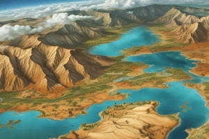
- Remote sensing provides a regional view of large areas, allowing for the collection of data over a broad range of territories.
- It offers repetitive looks at the same area, enabling the monitoring of changes over time.
- Remote sensors can "see" over a broader portion of the spectrum than the human eye, and can focus on specific bandwidths in an image or multiple bandwidths simultaneously.
Advantages of Remote Sensing
- Provides geo-referenced, digital data.
- Some remote sensors operate in all seasons, at night, and in bad weather.
Who Uses Remote Sensing and Why
- Geologists use remote sensing for minerals and oil prospecting.
- Geographers use remote sensing to detect changes on the Earth's surface that need to be mapped.
- Environmentalists use remote sensing to detect, identify, and follow the movement of pollutants.
- Foresters use remote sensing to gather information about tree types and disease effects.
- Farmers use remote sensing to monitor crop growth and effects of drought, floods, disease, or pests.
- Ship captains use remote sensing to navigate through northern ice packs.
- Firefighters use remote sensing to track the size and movement of forest fires.
Applications of Remote Sensing
- Military operations
- Geological mapping
- Geomorphology
- Hydrology
- Oceanography
- Vegetation
- Archaeology
- Agriculture
- Urban planning
- Landcover/landuse
- Weather
- Disaster management
- Geological applications: surficial deposit/bedrock mapping, lithological mapping, structural mapping, sand and gravel exploration, mineral exploration, environmental geology, and baseline infrastructure
Passive and Active Systems
- Passive systems detect radiation reflected from the target, while active systems emit radiation towards the target and detect the reflection.
- Radar is an example of active remote sensing, used by police to measure vehicle speed.
- A camera is an example of both passive and active remote sensing, depending on the lighting conditions.
Remote Sensing System
- Aerial photography involves taking photographs of the ground from an airborne platform.
- Photogrammetry involves making measurements and maps from photographs, especially from aerial surveying.
- Photogeology involves using aerial photographs to interpret geologic features.
Remote Sensing Process
- Energy Source (A)
- Radiation and Atmosphere (B)
- Interaction with Targets (C)
- Recording energy by sensor (D)
- Transmission and Reception (E)
- Interpretation and Analysis (F)
- Application (G)
Studying That Suits You
Use AI to generate personalized quizzes and flashcards to suit your learning preferences.
Description
This quiz covers the basics of remote sensing, including its definition, data collection methods, and its applications. It provides an overview of how remote sensing is used to obtain information about an object or area from a distance.