Podcast
Questions and Answers
What are the primary types of landforms identified in physical geography?
What are the primary types of landforms identified in physical geography?
- Mountains, Valleys, Rivers, Deserts
- Mountains, Plains, Plateaus, Valleys (correct)
- Forests, Swamps, Plains, Plateaus
- Hills, Cliffs, Canyons, Lakes
How is climate different from weather?
How is climate different from weather?
- Climate is only about temperature; Weather involves precipitation only.
- Climate focuses on atmospheric conditions; Weather is affected by seasons.
- Climate is short-term; Weather is long-term.
- Climate refers to long-term conditions; Weather refers to short-term conditions. (correct)
Which type of soil is known for its ability to hold moisture and is often good for agriculture?
Which type of soil is known for its ability to hold moisture and is often good for agriculture?
- Silt
- Loam (correct)
- Clay
- Sandy
What is a characteristic feature of ecosystems in physical geography?
What is a characteristic feature of ecosystems in physical geography?
Which process involves the accumulation of materials in new locations after erosion?
Which process involves the accumulation of materials in new locations after erosion?
Which natural hazard is caused primarily by tectonic movements?
Which natural hazard is caused primarily by tectonic movements?
Which of the following is NOT considered a climate zone?
Which of the following is NOT considered a climate zone?
What main factors influence soil formation?
What main factors influence soil formation?
Which of the following best describes plate tectonics?
Which of the following best describes plate tectonics?
What is the role of oceans in the Earth's climate?
What is the role of oceans in the Earth's climate?
Flashcards are hidden until you start studying
Study Notes
Physical Geography
Definition
- Branch of geography that deals with the natural environment and physical processes.
Key Components
-
Landforms
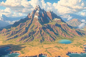
- Mountains: Elevated terrain, formed by tectonic forces.
- Plains: Flat or gently rolling areas, often fertile for agriculture.
- Plateaus: Elevated flatlands, often with steep sides.
- Valleys: Low areas between mountains, often shaped by rivers.
-
Climate and Weather
- Climate: Long-term atmospheric conditions in a region (temperature, precipitation).
- Weather: Short-term atmospheric conditions (daily conditions).
- Climate Zones: Tropical, arid, temperate, polar, etc.
-
Soils
- Types: Sandy, clay, silt, loam.
- Soil Formation: Influenced by parent material, climate, organisms, topography, and time.
- Importance: Supports agriculture, influences vegetation types.
-
Water Bodies
- Oceans: Largest water bodies, regulate climate, biodiversity hotspots.
- Rivers: Freshwater systems, essential for ecosystems and human settlement.
- Lakes: Variable size, can be freshwater or saline, important for ecosystems.
-
Ecosystems and Biomes
- Ecosystems: Interactions between living organisms and their environment.
- Biomes: Large ecological areas (e.g., forests, deserts, tundras) characterized by specific climate and vegetation.
-
Natural Hazards
- Earthquakes: Caused by tectonic movements, can lead to significant landform changes.
- Volcanoes: Eruptions can create new landforms and affect climate.
- Floods: Result from excessive rainfall or melting snow, impact land and human settlements.
Physical Processes
- Weathering: Breakdown of rocks through physical, chemical, and biological processes.
- Erosion: Removal and transportation of soil and rock by wind, water, or ice.
- Deposition: Accumulation of materials in new locations after erosion.
- Plate Tectonics: Movement of the Earth's lithospheric plates, responsible for earthquakes, mountains, and ocean trenches.
Importance of Physical Geography
- Understanding natural landscapes and their formation.
- Assessing natural resources and environmental challenges.
- Informing land-use planning, disaster management, and conservation efforts.
Definition
- Physical geography focuses on the natural environment and the processes that shape it.
Key Components
-
Landforms
- Mountains are elevated terrains formed by tectonic forces.
- Plains are flat or gently rolling areas, often fertile and suitable for agriculture.
- Plateaus consist of elevated flatlands characterized by steep sides.
- Valleys are low-lying areas between mountains, commonly shaped by river activity.
-
Climate and Weather
- Climate refers to long-term atmospheric conditions, including temperature and precipitation.
- Weather involves short-term atmospheric conditions, such as daily forecasts.
- Climate zones include categories like tropical, arid, temperate, and polar, each with unique characteristics.
-
Soils
- Soil types include sandy, clay, silt, and loam, each with distinct properties.
- Soil formation is influenced by factors like parent material, climate, organisms, topography, and time.
- Quality of soil supports agriculture and dictates vegetation types in regions.
-
Water Bodies
- Oceans are the largest water bodies, playing a crucial role in regulating the climate and supporting diverse ecosystems.
- Rivers serve as essential freshwater systems vital for both ecosystems and human habitation.
- Lakes range in size and can be either freshwater or saline, contributing significantly to local ecosystems.
-
Ecosystems and Biomes
- Ecosystems represent the interactions between living organisms and their environment.
- Biomes are extensive ecological areas (e.g., forests, deserts, tundras) defined by specific climatic conditions and vegetation types.
-
Natural Hazards
- Earthquakes occur as a result of tectonic plate movements, leading to notable landform alterations.
- Volcanic eruptions can create new landforms and influence climate patterns.
- Floods arise from excessive rainfall or melting snow, affecting land and human settlements significantly.
Physical Processes
- Weathering involves the breakdown of rocks through physical, chemical, and biological means.
- Erosion is the process of removing and transporting soil and rock via wind, water, or ice.
- Deposition refers to the accumulation of eroded materials in new locations.
- Plate Tectonics describes the movement of Earth's lithospheric plates, leading to earthquakes, mountain formation, and ocean trench creation.
Importance of Physical Geography
- Provides a framework for understanding natural landscapes and their developmental processes.
- Aids in assessing natural resources and recognizing environmental challenges.
- Informs strategies for land-use planning, disaster management, and conservation initiatives.
Studying That Suits You
Use AI to generate personalized quizzes and flashcards to suit your learning preferences.