Podcast
Questions and Answers
Which landform is characterized as elevated landforms, often formed by tectonic forces?
Which landform is characterized as elevated landforms, often formed by tectonic forces?
- Plateaus
- Mountains (correct)
- Valleys
- Plains
Oceans cover about 50% of Earth's surface.
Oceans cover about 50% of Earth's surface.
False (B)
What are the major ecological communities on land known as?
What are the major ecological communities on land known as?
Terrestrial Biomes
The __________ River is one of the essential rivers for ecosystems and human settlements.
The __________ River is one of the essential rivers for ecosystems and human settlements.
Match the following climates with their descriptions:
Match the following climates with their descriptions:
Which process refers to the breakdown of rocks into smaller particles influenced by climate?
Which process refers to the breakdown of rocks into smaller particles influenced by climate?
Lakes can only be freshwater bodies.
Lakes can only be freshwater bodies.
What is the impact of climate change on ecosystems?
What is the impact of climate change on ecosystems?
A __________ is an area typically flat or gently rolling, often fertile.
A __________ is an area typically flat or gently rolling, often fertile.
Which of the following is not classified as a type of soil?
Which of the following is not classified as a type of soil?
Flashcards are hidden until you start studying
Study Notes
Physical Geography
-
Definition: The branch of geography dealing with natural features and processes of the Earth.
-
Key Components:
-
Landforms:
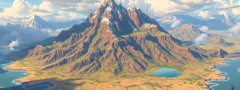
- Mountains: Elevated landforms, often formed by tectonic forces (e.g., Himalayas).
- Plains: Flat or gently rolling areas, typically fertile (e.g., Great Plains).
- Plateaus: Elevated flatlands, often with steep sides (e.g., Colorado Plateau).
- Valleys: Low areas between hills or mountains, often with rivers (e.g., Yosemite Valley).
-
Water Bodies:
- Rivers: Flowing watercourses, essential for ecosystems and human settlements (e.g., Amazon River).
- Lakes: Large inland bodies of water, can be freshwater or saline (e.g., Lake Superior).
- Oceans: Major bodies of saltwater, covering about 71% of Earth's surface (e.g., Pacific Ocean).
-
Climate and Weather:
- Climate Zones: Classification based on temperature and precipitation (e.g., tropical, temperate, polar).
- Weather Patterns: Short-term atmospheric conditions, influenced by geography (e.g., monsoons).
-
Soils:
- Types of Soil: Various soil profiles determined by weathering processes (e.g., clay, sandy, loamy).
- Soil Fertility: Influenced by nutrient content and organic matter, crucial for agriculture.
-
Ecosystems and Biomes:
- Terrestrial Biomes: Major ecological communities (e.g., forests, deserts, grasslands).
- Aquatic Ecosystems: Includes freshwater and marine environments (e.g., coral reefs, lakes).
-
-
Natural Processes:
- Weathering: Breakdown of rocks into smaller particles, influenced by climate.
- Erosion: Movement of soil and rock, often by water, wind, or ice.
- Tectonic Activity: Movement of Earth's plates leading to earthquakes, volcanism, and mountain formation.
-
Human Interaction:
- Impact of Climate Change: Effects on ecosystems, sea levels, and weather patterns.
- Natural Resource Management: Sustainable practices for land, water, and biodiversity conservation.
-
Mapping and Tools:
- Topographic Maps: Representation of landforms and elevation.
- Remote Sensing: Use of satellite imagery to analyze physical geography.
- GIS (Geographic Information Systems): Technology for mapping and analyzing spatial data.
Physical Geography Overview
- Focuses on natural features and processes of the Earth, including landforms, climate, soils, ecosystems, and human interactions.
Key Components of Physical Geography
-
Landforms:
- Mountains: Elevated regions formed by tectonic forces; example: Himalayas.
- Plains: Characterized by flat or gently rolling terrain; typically fertile, like the Great Plains.
- Plateaus: Elevated flatlands with steep sides; example: Colorado Plateau.
- Valleys: Low areas between hills or mountains, often containing rivers; example: Yosemite Valley.
-
Water Bodies:
- Rivers: Flowing watercourses vital for ecosystems and human settlements; example: Amazon River.
- Lakes: Large inland bodies of water, which can be either freshwater or saline; example: Lake Superior.
- Oceans: Major saltwater bodies covering about 71% of the Earth's surface; example: Pacific Ocean.
-
Climate and Weather:
- Climate Zones: Categories based on temperature and precipitation, including tropical, temperate, and polar.
- Weather Patterns: Short-term atmospheric conditions affected by geographical features; example: monsoons.
-
Soils:
- Types of Soil: Diverse soil profiles resulting from weathering; includes clay, sandy, and loamy soils.
- Soil Fertility: Determined by nutrient content and organic matter, essential for agriculture.
-
Ecosystems and Biomes:
- Terrestrial Biomes: Major ecological communities such as forests, deserts, and grasslands.
- Aquatic Ecosystems: Comprises freshwater (rivers, lakes) and marine environments (coral reefs).
Natural Processes
- Weathering: Breakdown of rocks into smaller particles, significantly influenced by climate conditions.
- Erosion: Movement of soil and rock material driven by water, wind, or ice processes.
- Tectonic Activity: Movement of Earth's plates responsible for earthquakes, volcanism, and mountain formation.
Human Interaction
- Impact of Climate Change: Affects ecosystems, sea levels, and weather patterns globally.
- Natural Resource Management: Involves sustainable practices designed to conserve land, water, and biodiversity.
Mapping and Tools
- Topographic Maps: Used to represent landforms and elevation variations visually.
- Remote Sensing: Employs satellite imagery to analyze various aspects of physical geography.
- GIS (Geographic Information Systems): A technology that facilitates mapping and spatial data analysis, enhancing geographic understanding.
Studying That Suits You
Use AI to generate personalized quizzes and flashcards to suit your learning preferences.


