Podcast
Questions and Answers
Which of the following are primary components of physical geography?
Which of the following are primary components of physical geography?
- Ecosystems (correct)
- Political Geography
- Hydrology (correct)
- Cultural Landscapes
Which term best describes areas of low land formed by erosion between mountains?
Which term best describes areas of low land formed by erosion between mountains?
- Valleys (correct)
- Basins
- Plains
- Plateaus
What is the primary factor influencing climate in a specific region?
What is the primary factor influencing climate in a specific region?
- Soil type
- Latitude (correct)
- Population density
- Urbanization
Which cycle describes the continuous movement of water in various forms through the environment?
Which cycle describes the continuous movement of water in various forms through the environment?
What type of biome is characterized by distinct climates and organisms like deserts and forests?
What type of biome is characterized by distinct climates and organisms like deserts and forests?
Which process involves the wearing away of land by natural forces such as wind, water, or ice?
Which process involves the wearing away of land by natural forces such as wind, water, or ice?
What term describes the relationship and interactions between organisms and their environment?
What term describes the relationship and interactions between organisms and their environment?
Which human activity is known to significantly alter natural systems and physical geography?
Which human activity is known to significantly alter natural systems and physical geography?
Flashcards are hidden until you start studying
Study Notes
Physical Geography
-
Definition: The study of natural features and processes of the Earth’s surface, including landforms, climates, ecosystems, and hydrology.
-
Key Components:
-
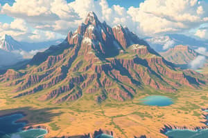
Landforms:
- Mountains: Elevated terrains formed by tectonic forces.
- Valleys: Low areas between mountains often formed by erosion.
- Plateaus: Flat elevated areas formed by volcanic activity or uplift.
- Plains: Broad, flat areas that are often fertile and suitable for agriculture.
-
Climate:
- Factors influencing climate: Latitude, elevation, proximity to water bodies, and prevailing winds.
- Climate Zones:
- Tropical (hot, humid)
- Arid (dry, desert-like)
- Temperate (moderate, with seasonal variations)
- Polar (cold, icy)
-
Ecosystems:
- Biomes: Large ecological areas with distinct climates and organisms (e.g., deserts, forests, tundras).
- Biodiversity: Variety of life forms in an ecosystem; essential for ecological balance.
- Interactions: Relationships between organisms and their environment, including food chains and nutrient cycles.
-
Hydrology:
- Water Cycle: The continuous movement of water through evaporation, condensation, precipitation, and runoff.
- Water Bodies: Includes rivers, lakes, oceans, and glaciers; critical for sustaining life and influencing climate.
- Watersheds: Areas of land that drain into a particular water body; important for understanding hydrological systems.
-
-
Processes:
- Erosion: The wearing away of land by wind, water, or ice.
- Weathering: The breakdown of rocks at the Earth's surface due to physical, chemical, or biological processes.
- Tectonic Activity: Movement of the Earth's plates causing earthquakes, volcanic activity, and mountain formation.
-
Human Impact:
- Climate Change: Alterations in climate patterns due to human activities; impacts ecosystems and weather events.
- Urbanization: Changes in land use affecting physical geography and natural systems.
- Conservation: Efforts to preserve natural landscapes and biodiversity in response to human impact.
-
Tools and Techniques:
- Geographic Information Systems (GIS): Technology for mapping and analyzing spatial data.
- Remote Sensing: Use of satellite or aerial imagery to monitor and assess land and environmental changes.
- Field Studies: Direct observation and data collection in specific locations to gain insights into physical geography.
Definition and Scope
- Focus on natural features and processes of the Earth’s surface, encompassing landforms, climates, ecosystems, and hydrology.
Key Components
Landforms
- Mountains: Formed by tectonic forces; elevated terrains.
- Valleys: Low-lying areas between mountains, primarily shaped by erosion.
- Plateaus: Flat elevated regions resulting from volcanic activity or geological uplift.
- Plains: Extensive flat areas, often fertile and conducive to agriculture.
Climate
- Influenced by geographic factors such as latitude, elevation, water proximity, and prevailing winds.
- Climate Zones:
- Tropical: Characterized by hot and humid conditions.
- Arid: Defined by dry, desert-like environments.
- Temperate: Experiences moderate temperatures with seasonal variations.
- Polar: Markedly cold and icy climates.
Ecosystems
- Biomes: Distinct large ecological units defined by unique climates and organisms, including deserts and forests.
- Biodiversity: Encompasses the variety of life forms within an ecosystem; vital for maintaining ecological balance.
- Interactions: Involves relationships between organisms and environments, including food chains and nutrient cycles.
Hydrology
- Water Cycle: Continuous movement of water through evaporation, condensation, precipitation, and runoff.
- Water Bodies: Includes essential resources like rivers, lakes, oceans, and glaciers; critical for life and climate regulation.
- Watersheds: Specific land areas that drain into particular water bodies; key for understanding hydrological systems.
Processes
- Erosion: The gradual wearing away of land due to wind, water, or ice.
- Weathering: Breakdown of rocks at the Earth's surface through physical, chemical, or biological means.
- Tectonic Activity: Movement of Earth's plates resulting in earthquakes, volcanic eruptions, and mountain formation.
Human Impact
- Climate Change: Human-induced alterations in climate patterns that affect ecosystems and weather phenomena.
- Urbanization: Changes in land use that impact physical geography and natural systems.
- Conservation: Efforts aimed at preserving natural landscapes and biodiversity in response to human activities.
Tools and Techniques
- Geographic Information Systems (GIS): Technology used for mapping and spatial data analysis.
- Remote Sensing: Applies satellite or aerial imagery to monitor land use and environmental changes.
- Field Studies: Involves direct observation and data collection in natural settings for deeper insights into physical geography.
Studying That Suits You
Use AI to generate personalized quizzes and flashcards to suit your learning preferences.