Podcast
Questions and Answers
Which phenomenon occurs in the zone of ablation?
Which phenomenon occurs in the zone of ablation?
- Transformation of névé into ice
- Accumulation of snow
- Recrystallization of snow
- Melting of ice (correct)
What characterizes the equilibrium line of a glacier?
What characterizes the equilibrium line of a glacier?
- It indicates the point of glacier formation
- It marks the highest point of accumulation
- It is the region of the glacier with maximum flow
- It separates zones of accumulation and ablation (correct)
Which cordillera has the largest glacier surface area?
Which cordillera has the largest glacier surface area?
- Cordillera de Ampato
- Cordillera de Huayhuas
- Cordillera Blanca (correct)
- Cordillera de Vilcanota
What process is involved in the zone of accumulation?
What process is involved in the zone of accumulation?
How many square kilometers of glacier surface area does the Cordillera de Vilcabamba have?
How many square kilometers of glacier surface area does the Cordillera de Vilcabamba have?
What occurs when the processes of accumulation equal the processes of ablation?
What occurs when the processes of accumulation equal the processes of ablation?
Which of the following is the highest peak in the tropical zone?
Which of the following is the highest peak in the tropical zone?
What is the depth of the Cotahuasi Canyon?
What is the depth of the Cotahuasi Canyon?
Which of the following valleys is located in Cusco?
Which of the following valleys is located in Cusco?
Which of the following is the longest pongo mentioned?
Which of the following is the longest pongo mentioned?
Where is the Qelgaya Glacier located?
Where is the Qelgaya Glacier located?
Which volcano is considered the most beautiful in Peru?
Which volcano is considered the most beautiful in Peru?
What is the primary cause of glacier movement?
What is the primary cause of glacier movement?
What are the materials transported by glaciers called?
What are the materials transported by glaciers called?
Which of the following statements about the Qelqaya Glacier is accurate?
Which of the following statements about the Qelqaya Glacier is accurate?
Which of the following cordilleras has the largest surface area in square kilometers?
Which of the following cordilleras has the largest surface area in square kilometers?
Which of the following is a consequence of glaciers retreating?
Which of the following is a consequence of glaciers retreating?
How do glaciers contribute to ecological stability?
How do glaciers contribute to ecological stability?
Which cordillera is located in both Arequipa and Puno?
Which cordillera is located in both Arequipa and Puno?
What is the combined surface area in square kilometers of the Huanzo and Ampato cordilleras?
What is the combined surface area in square kilometers of the Huanzo and Ampato cordilleras?
Which of the following is NOT a role of glaciers?
Which of the following is NOT a role of glaciers?
Which cordillera has the smallest surface area?
Which cordillera has the smallest surface area?
Which cordillera is situated primarily in the Huánuco region?
Which cordillera is situated primarily in the Huánuco region?
In which location can you find the Huaytapallana cordillera?
In which location can you find the Huaytapallana cordillera?
What is the area of Peru including its islands and Lake Titicaca?
What is the area of Peru including its islands and Lake Titicaca?
Which point in Peru is the highest in altitude?
Which point in Peru is the highest in altitude?
What is the total perimeter of Peru including its coastline?
What is the total perimeter of Peru including its coastline?
Which region in Peru receives the highest average rainfall?
Which region in Peru receives the highest average rainfall?
Which of the following statements about Peru's geographic limits is correct?
Which of the following statements about Peru's geographic limits is correct?
What is the length of Peru from its northernmost to southernmost point?
What is the length of Peru from its northernmost to southernmost point?
What is the lowest point in Peru, and where is it located?
What is the lowest point in Peru, and where is it located?
Which country shares the longest border with Peru?
Which country shares the longest border with Peru?
What percentage of the total area does the Andean region occupy in Peru?
What percentage of the total area does the Andean region occupy in Peru?
Which of the following geographical features is NOT mentioned as part of the Andes?
Which of the following geographical features is NOT mentioned as part of the Andes?
Which region in Peru experiences a climate that is dry and has little vegetation?
Which region in Peru experiences a climate that is dry and has little vegetation?
What is the maximum altitude of the Andean region in Peru?
What is the maximum altitude of the Andean region in Peru?
Which altitudinal zone is NOT part of the vertical structure of the Andean region?
Which altitudinal zone is NOT part of the vertical structure of the Andean region?
The Andes run through several countries. Which of the following is NOT one of them?
The Andes run through several countries. Which of the following is NOT one of them?
Which extreme point marks the southern limit of the Tacna province in Peru?
Which extreme point marks the southern limit of the Tacna province in Peru?
What is the primary characteristic of the Andean region's relief?
What is the primary characteristic of the Andean region's relief?
Flashcards are hidden until you start studying
Study Notes
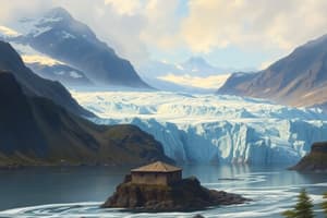
Glaciers in the Andes
- Glaciers form from the accumulation, compaction, and recrystallization of snow, indicating past or present flow.
- Zone of Accumulation: Upper glacier area where mass increases; snow transforms to névé and then ice.
- Zone of Ablation: Lower glacier area where mass is lost, primarily through melting.
- Equilibrium Line: Boundary separating accumulation from ablation zones.
Major Glacier Surfaces in the Andes
- Cordillera Blanca: 448 km² - Largest glacier area.
- Cordillera de Vilcanota: 255 km².
- Cordillera de Vilcabamba: 101 km².
- Cordillera de Ampato: 50 km².
- Cordillera de Huayhuas: 53 km².
Geographic Overview of the Andean Region
- The Andes stretch 7,240 km, the longest mountain range globally.
- Huascarán stands as the highest peak in the tropical Andes at 6,746 m.
- Coropuna is the region's tallest volcano at 6,426 m.
- Cotahuasi Canyon, located in Arequipa, is the world's deepest canyon at 3,535 m.
- The Qelqaya glacier in Cusco is the largest tropical glacier globally, spanning 44 km².
Inter-Andean Valleys
- Major inter-Andean valleys include Vilcanota, Watanay, Mapacho (Cusco), and Huanta (Ayacucho), among others.
Plateau Regions
- Key plateaus include Junin (Bombón), Parinacochas, and Pampa Galeras in Ayacucho, and Castrovieyna in Huancavelica.
Territorial Dimensions of Peru
- Total Area: 1,285,215.60 km²; the third largest country in South America.
- Length: 2,135 km; Width: 1,640 km.
- The coastline spans 3,080 km.
- Highest point: Huascarán (6,746 m); Lowest point: Bayovar Depression (-37 m).
Rainfall and Temperature Extremes
- Wettest region: Quince Mil, with rainfall of 8,000 mm.
- Hottest area: Neshuya, reaching 41 °C.
- Coldest place: Imata, dropping to -25 °C.
Borders and Geographical Limits
- Borders: Ecuador (1,528.5 km), Colombia (1,506 km), Brazil (2,822.5 km), Bolivia (1,047.1 km), Chile (169.1 km).
- Total perimeter exceeds 10,156.8 km, including coastal limits.
Physiographic Features of the Andes
- The Andean region has significant diversity in its landscape, comprising cordilleras, peaks, and volcanoes.
- Tectonic activity from the Mesozoic to Cenozoic gave rise to this varied topography.
Importance of Glaciers
- Glaciers are vital freshwater reserves and help maintain the hydrological balance.
- They support local ecosystems and provide water for human needs and activities.
Key Glaciers and Their Characteristics
- Glacier Qelqaya: Located in Vilcanota, 18 km long and 2.5 km wide, with over 200 m of thickness.
- Shows signs of retreat, exemplified by exposed rock and sediment patches.
Natural Regions of Peru
- Continental Areas: Coast (12.5%), Andes (30.2%), Amazon (57.3%).
- Maritime Area: Peruvian Sea.
Detailed Cordilleras of Peru (as of 2018 Inventory)
- Blanca, Huallanca: Significant glacier presence (448 km², 5 km² respectively).
- Huayhuas and Vilcabamba: Other notable cordilleras with respective areas of 53 km² and 101 km².
Summary of Andean Geography
- The Andean region showcases a complex interplay of climate zones, with a dry western slope and a humid eastern slope.
- It contains notable geological phenomena resulting from historical processes such as orogeny and volcanism.
Studying That Suits You
Use AI to generate personalized quizzes and flashcards to suit your learning preferences.