Podcast
Questions and Answers
What is the purpose of the FAA UFM (Unmanned Aircraft Systems Facility Map)?
What is the purpose of the FAA UFM (Unmanned Aircraft Systems Facility Map)?
- To visualize traffic patterns for manned aircraft.
- To understand airspace restrictions for drone operations. (correct)
- To calibrate drone compasses before flights.
- To create flight plans for commercial pilots.
Which of the following apps can be used to file for Lance authorization in controlled airspace?
Which of the following apps can be used to file for Lance authorization in controlled airspace?
- Open Sky (correct)
- UA Sidekick (correct)
- AirMap
- Skyvector
What is the recommended practice for drone compass calibration?
What is the recommended practice for drone compass calibration?
- Calibrate at any location regardless of magnetic interference.
- Calibrate after moving more than 20 miles from the last flight location. (correct)
- Calibrate using artificial lighting to eliminate errors.
- Calibrate near steel structures to improve accuracy.
What should be avoided when establishing a takeoff and landing area for drone operations?
What should be avoided when establishing a takeoff and landing area for drone operations?
Why is it advantageous to use an open grass location for compass calibration?
Why is it advantageous to use an open grass location for compass calibration?
The FAA UFM is important for understanding airspace restrictions and can be easily recalled by remembering 'FAA visualize it'.
The FAA UFM is important for understanding airspace restrictions and can be easily recalled by remembering 'FAA visualize it'.
Drone pilots do not need to maintain visual line of sight during drone operations.
Drone pilots do not need to maintain visual line of sight during drone operations.
It is advisable to perform compass calibration near magnetic materials like steel to improve accuracy.
It is advisable to perform compass calibration near magnetic materials like steel to improve accuracy.
Setting up cones around the takeoff and landing area is a recommended safety measure.
Setting up cones around the takeoff and landing area is a recommended safety measure.
If a drone has moved more than 20 miles from its last flight location, compass calibration is not required.
If a drone has moved more than 20 miles from its last flight location, compass calibration is not required.
Flashcards are hidden until you start studying
Study Notes
Overview of Onsite Workflow for Drone Missions
- Familiarize with mission location and check airspace through resources like skyvector.com and FAA's mapping tools.
- FAA UFM (Unmanned Aircraft Systems Facility Map) is crucial for understanding airspace restrictions; remember "FAA visualize it" for easy recall.
- Determine if operating environment has altitude limitations or is within controlled airspace.
- File for Lance authorization if operating in controlled airspace, using apps like Open Sky or UA Sidekick.
- Use UA Sidekick for privacy concerns; it is available at $5 per month.
- Create a detailed flight plan after surveying the site and noting any obstacles or obstructions.
- Drone operation must maintain visual line of sight; position yourself such that you can see the drone throughout the mission.
- Height restrictions apply; do not fly over moving individuals or traffic.
Setting Up and Conducting the Flight
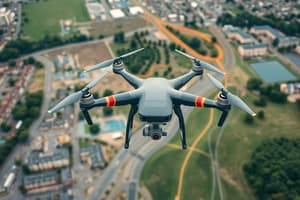
- Establish a clear takeoff and landing area, ideally using a landing pad to minimize debris on the camera lens.
- Set up cones around the area to keep bystanders away and ensure a safe working space.
- Prepare the drone by calibrating the compass if the drone has moved 20 miles from its last flight location due to magnetic declination.
- Avoid performing compass calibration near magnetic materials or structures like steel and reinforced concrete.
- Optimal calibration location is open grass to reduce magnetic interference and achieve accurate positioning.
- Proper compass calibration involves holding the drone correctly; improper handling can introduce errors into the mapping process.
Overview of Onsite Workflow for Drone Missions
- Familiarize with mission location and assess airspace using skyvector.com and FAA mapping tools.
- The FAA UFM (Unmanned Aircraft Systems Facility Map) is essential for identifying airspace restrictions; remember "FAA visualize it" for easy recall of this map.
- Check for altitude limitations and ensure the mission is not within controlled airspace; operational compliance is critical.
- If operating in controlled airspace, file for Lance authorization using apps such as Open Sky or UA Sidekick.
- UA Sidekick is available for $5 per month and is particularly useful for privacy management during flights.
- Develop a comprehensive flight plan after thoroughly surveying the site for obstacles and obstructions.
- Maintain visual line of sight with the drone throughout the mission; positioning is key for operational safety.
- Height restrictions must be adhered to, specifically avoiding flight over moving individuals or traffic.
Setting Up and Conducting the Flight
- Designate a clear takeoff and landing area; using a landing pad can help keep debris off the camera lens.
- Utilize cones to mark the designated area and prevent bystanders from approaching, ensuring a safe working environment.
- Calibrate the drone's compass if it has traveled more than 20 miles from its last flying location due to magnetic declination.
- Calibration should be performed away from magnetic materials or structures such as steel and reinforced concrete to avoid interference.
- An optimal calibration area is open grass, which minimizes magnetic interference and allows for accurate positioning of the drone.
- Ensure correct handling during compass calibration, as improper techniques can introduce errors into the drone's mapping process.
Studying That Suits You
Use AI to generate personalized quizzes and flashcards to suit your learning preferences.