Podcast
Questions and Answers
What is the average height of the Karakoram mountain range?
What is the average height of the Karakoram mountain range?
- 5000m
- 6000m (correct)
- 7000m
- 4000m
In which direction does the Karakoram mountain range run?
In which direction does the Karakoram mountain range run?
- South-East to North-West
- North-East to South-West
- East-West (correct)
- West-East
What is the highest peak of the Karakoram mountain range?
What is the highest peak of the Karakoram mountain range?
- Siachen
- Mount Everest
- Nanga Parbat
- K-2 (correct)
What is the location of the Great Himalayas?
What is the location of the Great Himalayas?
What is the average height of the Himalayas?
What is the average height of the Himalayas?
What is the highest peak of the Himalayas?
What is the highest peak of the Himalayas?
What is the location of the Sub-Himalayas?
What is the location of the Sub-Himalayas?
What is the altitude range of the Lesser Himalayas?
What is the altitude range of the Lesser Himalayas?
In which direction does the Hindu Kush range run?
In which direction does the Hindu Kush range run?
What is the average altitude of the Hindu Kush range?
What is the average altitude of the Hindu Kush range?
What is the highest peak of the Hindu Kush range?
What is the highest peak of the Hindu Kush range?
What is a characteristic feature of the Hindu Kush range?
What is a characteristic feature of the Hindu Kush range?
What is an important pass in the Hindu Kush range that connects Gilgit and Chitral?
What is an important pass in the Hindu Kush range that connects Gilgit and Chitral?
What is a limitation to human movement in the Northern Mountains?
What is a limitation to human movement in the Northern Mountains?
What is a source of income for people in the Hindu Kush range during summer?
What is a source of income for people in the Hindu Kush range during summer?
What is the origin of the Indus River?
What is the origin of the Indus River?
Flashcards are hidden until you start studying
Study Notes
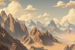
Northern Mountains
- Divided into three main mountain ranges: Karakoram, Himalayas, and Hindu Kush
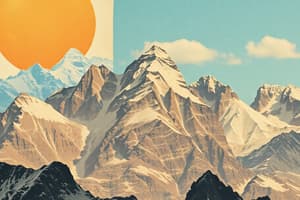
Karakoram Range
- Runs from South East to North-West with an average height of 6000m
- Stretches 400 km from Hunza to Shyok River and is 200 km wide
- Runs in an east-west direction
- Highest peak is K-2 (8610m)
- Features deep, narrow valleys and sharp peaks covered with snow and glaciers
- Siachen and Biafo are the main glaciers
Himalayas Range
- Runs from South-East to North-West with an average height of 4000m
- Divided into three sub-parallel ranges: Great Himalayas, Lesser Himalayas, and Sub-Himalayas
Great Himalayas
- Also known as Central Himalayas, mostly located in Kashmir
- Average height is 6000m
- Highest peak is Nanga Parbat (8126m)
- Rupal is the longest river
- Satpara is the largest lake of the region
- Indus River has set up a number of gorges in its path
- Peaks are snow-capped and steep-sided with large glaciers
Lesser Himalayas
- Located south of the Great Himalayas
- Medium height of 1800 to 4500 meters
- Feature hill stations like Murree, Ghora Gali, and Nathia Gali
- No glaciers are found in this region
Sub-Himalayas
- Also known as Siwaliks, located near Attock
- Low altitude of 600 to 1200 meters
Hindu Kush
- Lies on the north and north-west border of Pakistan
- Runs in a north-south direction
- Average altitude is 5000 meters
- Highest peak is Trich Mir (7690m)
- Features high, steep-sided valleys with narrow floors
- Important passes include Shandur, Lowari, and Shangla
- Bare of vegetation, except for forests in Swat, Chitral, and Dir valleys
Life of People and Economy
- Steep slopes, high peaks, and rugged landscape restrict human movement
- Limited land availability
- Small-scale agriculture is done on terraced fields
- Summer income sources include livestock and tourism
- Hydro-electric projects are set up on rivers
- Indoor activities like carpet making and embroidery are done in winter
Drainage Pattern
- River Indus and its tributaries are the main feature
- River Indus starts from Mansrowar Lake in Karakoram
- Joins with River Kabul and Swat
- Passes through dissected gorges and enters plain areas at Kalabagh
- Tributaries include Jhelum, Chenab, Sutlej, and Beas, which start from the Himalayas and join Indus at Mithankot
Studying That Suits You
Use AI to generate personalized quizzes and flashcards to suit your learning preferences.