Podcast
Questions and Answers
What is the approximate length of the Nico Ditch?
What is the approximate length of the Nico Ditch?
- 12 miles
- 3 miles
- 6 miles (correct)
- 1 mile
In which English county is the Nico Ditch located?
In which English county is the Nico Ditch located?
- Cheshire
- Lancashire
- Greater Manchester (correct)
- Yorkshire
The Nico Ditch was likely constructed between which centuries?
The Nico Ditch was likely constructed between which centuries?
- 1st and 4th
- 12th and 15th
- 16th and 18th
- 5th and 11th (correct)
What is a possible purpose of the Nico Ditch?
What is a possible purpose of the Nico Ditch?
What is the earliest documented name for the Nico Ditch?
What is the earliest documented name for the Nico Ditch?
What does 'magnum fossatum' mean?
What does 'magnum fossatum' mean?
Which of these towns is near the Nico Ditch?
Which of these towns is near the Nico Ditch?
The Nico Ditch might have been a boundary between which two kingdoms?
The Nico Ditch might have been a boundary between which two kingdoms?
According to legend, who built Nico Ditch in a single night?
According to legend, who built Nico Ditch in a single night?
What is the width of the Nico Ditch in the sections that remain?
What is the width of the Nico Ditch in the sections that remain?
In which park can a well-preserved section of the Nico Ditch be found?
In which park can a well-preserved section of the Nico Ditch be found?
What is the approximate depth of the Nico Ditch in the sections that remain?
What is the approximate depth of the Nico Ditch in the sections that remain?
Which of the following best describes the shape of the Nico Ditch's profile?
Which of the following best describes the shape of the Nico Ditch's profile?
In what year was a section of the Nico Ditch in Platt Fields designated as a Scheduled Ancient Monument?
In what year was a section of the Nico Ditch in Platt Fields designated as a Scheduled Ancient Monument?
What is the meaning of the Anglo-Saxon word 'micel'?
What is the meaning of the Anglo-Saxon word 'micel'?
Which golf course contains a 330-yard stretch of the Nico Ditch?
Which golf course contains a 330-yard stretch of the Nico Ditch?
The Audenshaw Reservoirs were built partially over which historical site?
The Audenshaw Reservoirs were built partially over which historical site?
What was the conclusion of the University of Manchester Archaeological Unit project regarding the ditch's purpose?
What was the conclusion of the University of Manchester Archaeological Unit project regarding the ditch's purpose?
Which of the following is a possible derivation of the name 'Nico'?
Which of the following is a possible derivation of the name 'Nico'?
What is the grid reference of the Nico Ditch where it ends in Ashton-under-Lyne?
What is the grid reference of the Nico Ditch where it ends in Ashton-under-Lyne?
Flashcards
What is the Nico Ditch?
What is the Nico Ditch?
A six-mile long earthwork in Greater Manchester, England.
Possible purpose of the Nico Ditch
Possible purpose of the Nico Ditch
Defensive fortification or boundary marker.
When was Nico Ditch likely built?
When was Nico Ditch likely built?
Between the 5th and 11th century.
Early name for Nico Ditch
Early name for Nico Ditch
Signup and view all the flashcards
Meaning of 'micel'
Meaning of 'micel'
Signup and view all the flashcards
Course of Nico Ditch
Course of Nico Ditch
Signup and view all the flashcards
Nico Ditch as a boundary.
Nico Ditch as a boundary.
Signup and view all the flashcards
Legend of Nico Ditch battle
Legend of Nico Ditch battle
Signup and view all the flashcards
Evidence against defensive purpose
Evidence against defensive purpose
Signup and view all the flashcards
Probable purpose based on excavations
Probable purpose based on excavations
Signup and view all the flashcards
Best-preserved sections of Nico Ditch
Best-preserved sections of Nico Ditch
Signup and view all the flashcards
Preservation status of Nico Ditch
Preservation status of Nico Ditch
Signup and view all the flashcards
Study Notes
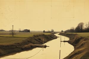
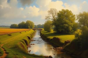
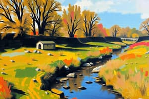
- Nico Ditch is a 6 mi (9.7 km) linear earthwork in Greater Manchester, England.
- It stretches between Ashton-under-Lyne and Stretford.
- It was built between the 5th and 11th centuries.
- Its purpose was for defense or as a boundary marker.
- Surviving sections are 4–5 yards (3.7–4.6 m) wide and up to 5 ft (1.5 m) deep.
- A portion of the earthwork has protected status as a Scheduled Ancient Monument.
Etymology
- The earliest reference to the ditch is in a charter from 1190-1212.
- The charter details land grants in Audenshaw to Kersal Cell monks.
- The ditch was called "Mykelldiche" and magnum fossatum (Latin for "large ditch").
- The name Nico became common in the 19th and 20th centuries.
- Nico may come from the Anglo-Saxon Hnickar (a water spirit).
- It is likely a corruption of Mykelldiche, where micel means "big" in Anglo-Saxon.
- Another possible origin is from nǽcan, an Anglo-Saxon verb meaning "kill".
Course
- Nico Ditch runs 6 mi (9.7 km) from Ashton Moss to Hough Moss (east of Stretford).
- It goes through Denton, Reddish, Gorton, Levenshulme, Burnage, Rusholme, Platt Fields Park, Withington, & Chorlton-cum-Hardy.
- It crosses four boroughs of Greater Manchester.
- The ditch marks boundaries between Stockport and Manchester, and Tameside and Manchester.
- It extends to Denton golf course.
- Part of the ditch is under the Audenshaw Reservoirs, built in the late 19th century.
- It may have stretched west beyond Stretford, to Urmston.
History
- The ditch was built between the 5th century (end of Roman rule) and the Norman conquest in 1066.
- It may have been a defensive fortification or an administrative boundary.
- It might have marked a 7th-century boundary for Anglo-Saxon expansion.
- Alternatively, it could have been a late 8th or early 9th century boundary between Mercia and Northumbria.
- Northumbria, Mercia, and Wessex fought for control of North West England in the early medieval period.
- The ditch has been used as a boundary since the Middle Ages.
- Legend says the inhabitants of Manchester built it in a single night in 869–870 to protect against Viking invaders.
- Each man had to dig his section and build a bank as tall as himself.
- 19th-century folklore says a battle between Saxons and Danes occurred at the ditch.
- Gorton and Reddish were said to get their names from this battle ("Gore Town" and "Red-Ditch").
- Historians dismiss this, saying the names mean "dirty farmstead" and "reedy ditch".
- Antiquarians and historians have been interested in the ditch since the 19th century, but much has been built over.
- The University of Manchester Archaeological Unit excavated sections of the ditch between 1990 and 1997.
- The goal was to determine its age and purpose.
- No construction date was established.
- Investigations found that the bank to the north of the ditch is of 20th-century origin.
- Its profile is U-shaped, not the V-shape typical of military ditches.
- This suggests the ditch was a territorial boundary marker.
- The project concluded that the ditch was probably a boundary marker.
Preservation
- The ditch is still visible in short sections, despite weathering.
- Sections are 4–5 yards (3.7–4.6 m) wide and up to 5 ft (1.5 m) deep.
- The best-preserved remains are in Denton Golf Course (330 yards/300 m) and Platt Fields Park.
- A 150-yard (140 m) section in Platt Fields was protected as a Scheduled Ancient Monument in 1997.
- The rest of the ditch remains unprotected.
Studying That Suits You
Use AI to generate personalized quizzes and flashcards to suit your learning preferences.