Podcast
Questions and Answers
Where is the Nico Ditch located?
Where is the Nico Ditch located?
- Yorkshire, England
- Greater Manchester, England (correct)
- Scotland
- Wales
What is the approximate length of the Nico Ditch?
What is the approximate length of the Nico Ditch?
- 3 miles
- 12 miles
- 1 mile
- 6 miles (correct)
What was the Nico Ditch possibly used for?
What was the Nico Ditch possibly used for?
- Housing
- Road
- Defensive fortification (correct)
- Irrigation system
During what period was the Nico Ditch likely constructed?
During what period was the Nico Ditch likely constructed?
What is the earliest documented name for the Nico Ditch?
What is the earliest documented name for the Nico Ditch?
What does the Anglo-Saxon word 'micel' mean?
What does the Anglo-Saxon word 'micel' mean?
Through which of these locations does the Nico Ditch NOT pass?
Through which of these locations does the Nico Ditch NOT pass?
What may the Nico Ditch have marked the boundary between?
What may the Nico Ditch have marked the boundary between?
According to legend, who were the inhabitants of Manchester protecting themselves from when they built the Nico Ditch?
According to legend, who were the inhabitants of Manchester protecting themselves from when they built the Nico Ditch?
In which park is a well-preserved section of the Nico Ditch located?
In which park is a well-preserved section of the Nico Ditch located?
What is the shape of the Nico Ditch's profile?
What is the shape of the Nico Ditch's profile?
In which century did antiquarians and historians begin to show interest in the Nico Ditch?
In which century did antiquarians and historians begin to show interest in the Nico Ditch?
Which of these is closest to the width of the Nico Ditch?
Which of these is closest to the width of the Nico Ditch?
What is the name of the golf course where a section of the Nico Ditch is still visible?
What is the name of the golf course where a section of the Nico Ditch is still visible?
What is the length of the well-preserved segment of the Nico Ditch in Platt Fields that has been protected?
What is the length of the well-preserved segment of the Nico Ditch in Platt Fields that has been protected?
What is the modern name 'Nico' likely a corruption of?
What is the modern name 'Nico' likely a corruption of?
What is the Anglo-Saxon verb 'náecan' said to mean?
What is the Anglo-Saxon verb 'náecan' said to mean?
Under what were parts of the Nico Ditch submerged towards the end of the 19th century?
Under what were parts of the Nico Ditch submerged towards the end of the 19th century?
When was the bank to the north of the Nico Ditch determined to originate from?
When was the bank to the north of the Nico Ditch determined to originate from?
What is the height up to which, the Nico Ditch can reach?
What is the height up to which, the Nico Ditch can reach?
Flashcards
What is the Nico Ditch?
What is the Nico Ditch?
A six-mile long linear earthwork in Greater Manchester, thought to be a defensive fortification or boundary marker.
When was Nico Ditch likely built?
When was Nico Ditch likely built?
Between the 5th and 11th century.
Origin of 'Nico' in Nico Ditch?
Origin of 'Nico' in Nico Ditch?
A water spirit that drowns travelers, or a corruption of 'Mykelldiche'.
Course of the Nico Ditch?
Course of the Nico Ditch?
Signup and view all the flashcards
Original purpose of Nico Ditch?
Original purpose of Nico Ditch?
Signup and view all the flashcards
Which kingdoms struggled for control over North West England during the early medieval period?
Which kingdoms struggled for control over North West England during the early medieval period?
Signup and view all the flashcards
What event supposedly prompted the Nico Ditch construction in a single night?
What event supposedly prompted the Nico Ditch construction in a single night?
Signup and view all the flashcards
What purpose did archaeological investigations suggest for the Nico Ditch?
What purpose did archaeological investigations suggest for the Nico Ditch?
Signup and view all the flashcards
Where are the best-preserved sections of Nico Ditch?
Where are the best-preserved sections of Nico Ditch?
Signup and view all the flashcards
Which segment of the Nico Ditch is protected as a Scheduled Ancient Monument?
Which segment of the Nico Ditch is protected as a Scheduled Ancient Monument?
Signup and view all the flashcards
Study Notes
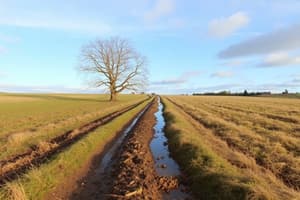
- Nico Ditch is a 6 mi (9.7 km) linear earthwork in Greater Manchester, England, stretching from Ashton-under-Lyne to Stretford.
- Constructed between the 5th and 11th centuries, it served as a defensive fortification or boundary marker.
- Short sections of the ditch remain visible today, including a 330-yard (300 m) stretch at Denton Golf Course.
- Surviving sections are 4–5 yards (3.7–4.6 m) wide and up to 5 feet (1.5 m) deep.
- A part of Nico Ditch is protected as a Scheduled Ancient Monument.
Etymology
- The earliest reference to the ditch appears in a charter from 1190-1212, granting land in Audenshaw to the monks of Kersal Cell, referring to it as "Mykelldiche" and magnum fossatum.
- "Nico" (or "Nikker") became the common name in the 19th and 20th centuries.
- The name "Nico" is likely a corruption of "Mykelldiche", where the Anglo-Saxon word "micel" meant "big" or "great".
- An alternative origin for "Nico" is from "nǽcan", an Anglo-Saxon verb meaning "kill".
Course
- Nico Ditch spans from Ashton Moss in Ashton-under-Lyne to Hough Moss, east of Stretford.
- It traverses Denton, Reddish, Gorton, Levenshulme, Burnage, Rusholme, Platt Fields Park, Withington, and Chorlton-cum-Hardy.
- The ditch crosses four metropolitan boroughs within Greater Manchester.
- It aligns with boundaries between Stockport and Manchester, and Tameside and Manchester.
- The ditch may have extended further west to Urmston.
History
- The earthwork was built sometime between the end of Roman rule in the early 5th century and the Norman conquest in 1066.
- The ditch may have been a 7th-century boundary for Anglo-Saxon expansion or a boundary marker between Mercia and Northumbria in the late 8th or early 9th century.
- In the early medieval period, Northumbria, Mercia, and Wessex struggled for control over North West England.
- Legend says the ditch was constructed in a single night by the inhabitants of Manchester as protection against Viking invaders in 869–870.
- Folklore suggested that the towns of Gorton and Reddish derived their names from a Saxon-Dane battle at the ditch ("Gore Town" and "Red-Ditch"), but this is dismissed by historians.
- Historians and antiquarians have studied the ditch since the 19th century, but much of it has been built over.
- Excavations from 1990-1997 sought to determine the ditch's age and purpose.
- The U-shaped profile and the 20th-century origin of the bank to the north suggest it was a territorial boundary marker.
Preservation
- Despite weathering, short sections of the ditch are still visible, measuring 4–5 yards (3.7–4.6 m) wide and up to 5 feet (1.5 m) deep.
- The best-preserved sections are in Denton Golf Course (330 yards/300 m) and Platt Fields Park.
- A 150-yard (140 m) segment in Platt Fields was protected as a Scheduled Ancient Monument in 1997.
- The rest of the ditch is unprotected.
Studying That Suits You
Use AI to generate personalized quizzes and flashcards to suit your learning preferences.