Podcast
Questions and Answers
What is the approximate length of the Nico Ditch?
What is the approximate length of the Nico Ditch?
- 9.7 kilometers (correct)
- 5 kilometers
- 15 kilometers
- 20 kilometers
In which English county is the Nico Ditch located?
In which English county is the Nico Ditch located?
- Cheshire
- Greater Manchester (correct)
- Yorkshire
- Lancashire
The Nico Ditch was possibly used as a defensive fortification or what else?
The Nico Ditch was possibly used as a defensive fortification or what else?
- A water source
- A religious site
- A trade route
- A boundary marker (correct)
During which period was the Nico Ditch likely constructed?
During which period was the Nico Ditch likely constructed?
What is the Latin term used to describe the Nico Ditch in an early charter?
What is the Latin term used to describe the Nico Ditch in an early charter?
What is the possible origin of the name 'Nico' in Nico Ditch?
What is the possible origin of the name 'Nico' in Nico Ditch?
The Nico Ditch passes through which of these present-day areas?
The Nico Ditch passes through which of these present-day areas?
What is the approximate width of the Nico Ditch where it is still visible?
What is the approximate width of the Nico Ditch where it is still visible?
Which two possible purposes are suggested for the construction of the Nico Ditch?
Which two possible purposes are suggested for the construction of the Nico Ditch?
Legend connects the Nico Ditch to defense against which group of invaders?
Legend connects the Nico Ditch to defense against which group of invaders?
Historians have dismissed what origin story about the names of Gorton and Reddish?
Historians have dismissed what origin story about the names of Gorton and Reddish?
Which university conducted excavations of the Nico Ditch between 1990 and 1997?
Which university conducted excavations of the Nico Ditch between 1990 and 1997?
What shape is the ditch's profile, suggesting it was for marking a territorial boundary?
What shape is the ditch's profile, suggesting it was for marking a territorial boundary?
In which park is a well-preserved section of the Nico Ditch located?
In which park is a well-preserved section of the Nico Ditch located?
What is the status of the 150-yard segment of the Nico Ditch in Platt Fields?
What is the status of the 150-yard segment of the Nico Ditch in Platt Fields?
What does the Anglo-Saxon word 'micel' mean, relating to the ditch's early name?
What does the Anglo-Saxon word 'micel' mean, relating to the ditch's early name?
The Nico Ditch coincides with boundaries between which two boroughs?
The Nico Ditch coincides with boundaries between which two boroughs?
Which of these locations is the easternmost point of the Nico Ditch's course?
Which of these locations is the easternmost point of the Nico Ditch's course?
What event occurred in the early medieval period that may relate to the Nico Ditch's purpose?
What event occurred in the early medieval period that may relate to the Nico Ditch's purpose?
Sections of the Nico Ditch are now located beneath what structure?
Sections of the Nico Ditch are now located beneath what structure?
Flashcards
What is Nico Ditch?
What is Nico Ditch?
A six-mile long earthwork in Greater Manchester, thought to be a defensive fortification or boundary marker.
When was Nico Ditch built?
When was Nico Ditch built?
Between the 5th and 11th century.
How long is Nico Ditch?
How long is Nico Ditch?
Approximately 6 miles (9.7 km).
What was the earliest name for Nico Ditch?
What was the earliest name for Nico Ditch?
Signup and view all the flashcards
What does "Nico" mean?
What does "Nico" mean?
Signup and view all the flashcards
Where does Nico Ditch Stretch?
Where does Nico Ditch Stretch?
Signup and view all the flashcards
What was the original purpose of Nico Ditch?
What was the original purpose of Nico Ditch?
Signup and view all the flashcards
What kingdoms might Nico Ditch divide?
What kingdoms might Nico Ditch divide?
Signup and view all the flashcards
What do archaeological investigations suggest about the ditch's purpose?
What do archaeological investigations suggest about the ditch's purpose?
Signup and view all the flashcards
Where are the best-preserved remains of Nico Ditch?
Where are the best-preserved remains of Nico Ditch?
Signup and view all the flashcards
Where is Nico Ditch protected as a Scheduled Ancient Monument?
Where is Nico Ditch protected as a Scheduled Ancient Monument?
Signup and view all the flashcards
Study Notes
- Nico Ditch is a 6 mi (9.7 km) linear earthwork between Ashton-under-Lyne and Stretford, Greater Manchester.
- It was built between the 5th and 11th centuries.
- The original purpose of the ditch was either for defence or as a boundary marker.
- Some parts of it is still visible with the ditch being 4–5 yards (3.7–4.6 m) wide and up to 5 ft (1.5 m) deep.
- Part of the earthwork is protected as a Scheduled Ancient Monument.
Etymology
- The earliest reference to the ditch is in a land charter from 1190-1212, calling it "Mykelldiche" and magnum fossatum (Latin for "large ditch").
- The name Nico became established in the 19th and 20th century.
- Nico might be derived from the Anglo-Saxon Hnickar, a water spirit.
- The modern name is likely a corruption of Mykelldiche, where micel means "big" or "great".
- Another possible origin for Nico is from the Anglo-Saxon verb nǽcan, meaning "to kill".
Course
- The ditch stretches 6 mi (9.7 km) from Ashton Moss (SJ909980) to Hough Moss (SJ82819491), east of Stretford.
- It passes through Denton, Reddish, Gorton, Levenshulme, Burnage, Rusholme, Platt Fields Park, Withington, and Chorlton-cum-Hardy.
- It crosses four metropolitan boroughs of Greater Manchester.
- The ditch coincides with the boundaries between Stockport and Manchester, and Tameside and Manchester.
- A section is under the Audenshaw Reservoirs.
- The ditch may have extended west to Urmston (SJ78299504).
History
-
The earthwork was built between the end of Roman rule in Britain (early 5th century) and the Norman conquest (1066).
-
It may have been a defensive fortification or an administrative boundary.
-
It possibly marked a 7th-century boundary for the Anglo-Saxons, or a late 8th/early 9th century boundary between Mercia and Northumbria.
-
During the early medieval period, Northumbria, Mercia, and Wessex fought for control of North West England with the Britons and Danes.
-
The ditch has been used as a boundary since at least the Middle Ages.
-
Legend says the ditch was completed in one night by the inhabitants of Manchester to protect against Viking invaders in 869–870.
-
Each man had to dig his section and build a bank equal to his height.
-
19th-century folklore claimed the ditch was the site of a battle between Saxons and Danes.
-
The names Gorton and Reddish were said to come from "Gore Town" and "Red-Ditch", but historians dismiss this as a "popular fancy".
-
The names Gorton and Reddish actually derive from "dirty farmstead" and "reedy ditch" respectively.
-
Antiquarians and historians have been interested in the ditch since the 19th century.
-
From 1990-1997, the University of Manchester Archaeological Unit excavated sections of the ditch to determine its age and purpose.
-
Investigations showed the bank north of the ditch is of 20th-century origin.
-
The ditch's U-shape suggests it was a territorial boundary marker.
-
The project concluded that the ditch was probably a boundary marker.
Preservation
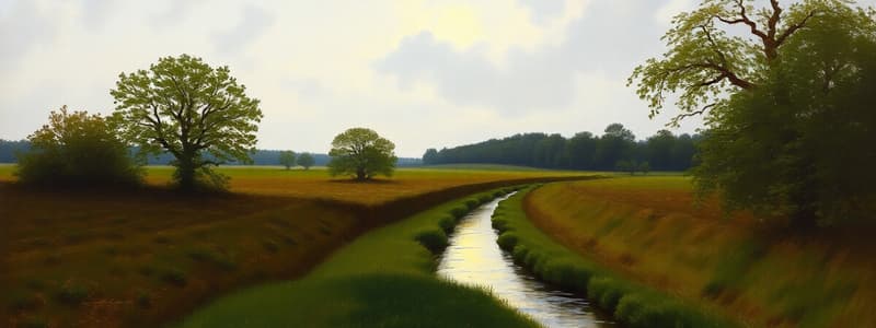
- The ditch is still visible in short sections, up to 4–5 yards (3.7–4.6 m) wide and up to 5 ft (1.5 m) deep.
- A 330-yard (300 m) stretch through Denton Golf Course, and a section in Platt Fields Park, are the best-preserved remains.
- A 150-yard (140 m) segment in Platt Fields was protected as a Scheduled Ancient Monument in 1997.
- The rest of the ditch remains unprotected.
Studying That Suits You
Use AI to generate personalized quizzes and flashcards to suit your learning preferences.