Podcast
Questions and Answers
What is the approximate length of Nico Ditch?
What is the approximate length of Nico Ditch?
- 15 kilometers
- 20 kilometers
- 9.7 kilometers (correct)
- 5 kilometers
In which English county is Nico Ditch located?
In which English county is Nico Ditch located?
- Lancashire
- Greater Manchester (correct)
- Yorkshire
- Cheshire
When was Nico Ditch likely constructed?
When was Nico Ditch likely constructed?
- Between the 5th and 11th century (correct)
- During Roman times
- During the 15th century
- During the Victorian era
What was a possible purpose of Nico Ditch?
What was a possible purpose of Nico Ditch?
What is the meaning of magnum fossatum?
What is the meaning of magnum fossatum?
In what century did the name 'Nico Ditch' become established?
In what century did the name 'Nico Ditch' become established?
What does the Anglo-Saxon word micel mean?
What does the Anglo-Saxon word micel mean?
Nico Ditch passes through which park in Fallowfield?
Nico Ditch passes through which park in Fallowfield?
What is the name of the golf course where a section of Nico Ditch is still visible?
What is the name of the golf course where a section of Nico Ditch is still visible?
What is the possible derivation of the name 'Nico'?
What is the possible derivation of the name 'Nico'?
What is the width of the Nico Ditch in the areas that remain?
What is the width of the Nico Ditch in the areas that remain?
The Nico Ditch coincides with boundaries between which boroughs?
The Nico Ditch coincides with boundaries between which boroughs?
What was the conclusion of the University of Manchester Archaeological Unit's project regarding the ditch?
What was the conclusion of the University of Manchester Archaeological Unit's project regarding the ditch?
The Nico Ditch may have been a boundary marker between which kingdoms?
The Nico Ditch may have been a boundary marker between which kingdoms?
According to legend, Nico Ditch was built as a defense against whom?
According to legend, Nico Ditch was built as a defense against whom?
What is the meaning of 'Gorton', derived from the Old English?
What is the meaning of 'Gorton', derived from the Old English?
As a Scheduled Ancient Monument, what length of the Nico Ditch in Platt Fields is protected?
As a Scheduled Ancient Monument, what length of the Nico Ditch in Platt Fields is protected?
The Audenshaw Reservoirs were built at the end of which century?
The Audenshaw Reservoirs were built at the end of which century?
What is the meaning of Reddish?
What is the meaning of Reddish?
Flashcards
What is the Nico Ditch?
What is the Nico Ditch?
A six-mile (9.7 km) long linear earthwork in Greater Manchester, England, possibly used as a defensive fortification or boundary marker.
When was Nico Ditch constructed?
When was Nico Ditch constructed?
Between the 5th and 11th century.
What are the dimensions of Nico Ditch?
What are the dimensions of Nico Ditch?
The ditch is still visible in short sections and can be up to 4–5 yards (3.7–4.6 m) wide and up to 5 feet (1.5 m) deep.
What was the earliest name for Nico Ditch?
What was the earliest name for Nico Ditch?
Signup and view all the flashcards
What boundaries does Nico Ditch coincide with?
What boundaries does Nico Ditch coincide with?
Signup and view all the flashcards
What was the original purpose of Nico Ditch?
What was the original purpose of Nico Ditch?
Signup and view all the flashcards
What's the legend behind Nico Ditch?
What's the legend behind Nico Ditch?
Signup and view all the flashcards
What did excavations reveal about Nico Ditch?
What did excavations reveal about Nico Ditch?
Signup and view all the flashcards
Where are the best-preserved remains of Nico Ditch?
Where are the best-preserved remains of Nico Ditch?
Signup and view all the flashcards
What part of Nico Ditch is a Scheduled Ancient Monument?
What part of Nico Ditch is a Scheduled Ancient Monument?
Signup and view all the flashcards
Study Notes
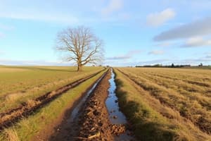
- Nico Ditch is a 6 mi (9.7 km) long earthwork situated between Ashton-under-Lyne and Stretford, Greater Manchester, England.
- It's a linear structure that was either a defensive fortification or a boundary marker.
- Construction occurred sometime between the 5th and 11th centuries.
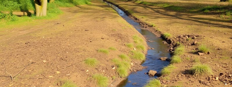
- Select portions of the ditch remain visible, with one notable stretch measuring 330 yards (300 m) on Denton Golf Course.
- The surviving ditch sections measure 4–5 yards (3.7–4.6 m) in width and up to 5 ft (1.5 m) in depth.
- Some parts of the earthwork are under protection as a Scheduled Ancient Monument.
Etymology
- The earliest reference is in a charter from 1190-1212, granting land in Audenshaw to Kersal Cell monks, referring to it as "Mykelldiche" and magnum fossatum (Latin for "large ditch").
- The name Nico (or Nikker) appeared in the 19th-20th century.
- "Nico" might come from the Anglo-Saxon "Hnickar", a water spirit, but is more likely a corruption of "Mykelldiche".
- The Anglo-Saxon word "micel" translates to "big" or "great".
- An alternate theory suggests "Nico" comes from "nǽcan", an Anglo-Saxon verb for "kill".
Course
- The ditch runs 6 mi (9.7 km) from Ashton Moss (SJ909980) in Ashton-under-Lyne to Hough Moss (SJ82819491) east of Stretford.
- It traverses Denton, Reddish, Gorton, Levenshulme, Burnage, Rusholme, Platt Fields Park, Withington, and Chorlton-cum-Hardy.
- Crossing the metropolitan boroughs of Stockport, Manchester and Tameside.
- Part of the ditch is submerged beneath the Audenshaw Reservoirs, built in the late 19th century.
- There is a possibility that the ditch extended further west beyond Stretford to Urmston (SJ78299504).
History
- The construction took place between the end of Roman rule in Britain (early 5th century) and the Norman conquest of 1066.
- Its purpose is speculated to be a defensive fortification or an administrative boundary.
- One theory suggests it marked a 7th-century boundary for Anglo-Saxon expansion.
- Another theory posits it as a boundary between the kingdoms of Mercia and Northumbria in the late 8th or early 9th century.
- Throughout the early medieval period, Northumbria, Mercia, and Wessex struggled for control over North West England along with the Britons and the Danes.
- Regardless of its initial function, it has served as a boundary since at least the Middle Ages.
- Legend says the ditch was built in a single night by Manchester inhabitants as defense against Viking invaders in 869–870.
- Each man was assigned an area to dig and build a bank as tall as himself.
- 19th-century folklore suggests a battle between Saxons and Danes occurred at the ditch.
- The towns Gorton and Reddish were named after this battle ("Gore Town" and "Red-Ditch") but historians consider this a "popular fancy".
- The names Gorton and Reddish actually mean "dirty farmstead" and "reedy ditch" respectively.
- Antiquarians and historians have studied the ditch since the 19th century.
- The University of Manchester Archaeological Unit excavated sections of the ditch in Denton, Reddish, Levenshulme, and Platt Fields (1990-1997) to determine its age and purpose.
- These investigations determined that the bank north of the ditch originated in the 20th century.
- The ditch's U-shape suggests that it was a territorial boundary.
Preservation
- Despite weathering, the ditch is still visible in short sections measuring 4–5 yards (3.7–4.6 m) wide and up to 5 feet (1.5 m) deep.
- The 330-yard (300 m) stretch on Denton Golf Course and the section in Platt Fields Park are the best-preserved remains.
- A 150-yard (140 m) segment of the ditch within Platt Fields was protected as a Scheduled Ancient Monument in 1997.
- The rest of the ditch remains unprotected.
Studying That Suits You
Use AI to generate personalized quizzes and flashcards to suit your learning preferences.