Podcast
Questions and Answers
Which of the following map projections is known for preserving accurate directions, making it useful for navigation, but significantly distorts the size and shape of landmasses?
Which of the following map projections is known for preserving accurate directions, making it useful for navigation, but significantly distorts the size and shape of landmasses?
- Robinson Projection
- Fuller Projection
- Mercator Projection (correct)
- Goode Homolosine Projection
Which map projection minimizes distortion of size and shape, particularly of land masses, but exhibits distortion at the poles?
Which map projection minimizes distortion of size and shape, particularly of land masses, but exhibits distortion at the poles?
- Mercator Projection
- Gall-Peters Projection
- Robinson Projection (correct)
- Goode Homolosine Projection
Which type of map is specifically designed to display spatial patterns of places using quantitative data, often employing color to represent different values or categories?
Which type of map is specifically designed to display spatial patterns of places using quantitative data, often employing color to represent different values or categories?
- Flowline Map
- Thematic Map (correct)
- Topographic Map
- Reference Map
Which of the following map types uses lines to connect areas with similar or equal data values, often used in weather maps to show temperature or pressure?
Which of the following map types uses lines to connect areas with similar or equal data values, often used in weather maps to show temperature or pressure?
Which of the following best describes 'relative location'?
Which of the following best describes 'relative location'?
What is the primary function of reference maps?
What is the primary function of reference maps?
If a geographer is analyzing photos of a town to understand its culture, population density, and current events, what type of data collection are they employing?
If a geographer is analyzing photos of a town to understand its culture, population density, and current events, what type of data collection are they employing?
A local government uses geographic data to identify areas suitable for building new schools and to manage land use regulations. What is this process commonly known as?
A local government uses geographic data to identify areas suitable for building new schools and to manage land use regulations. What is this process commonly known as?
Which concept explains how the interaction between two places decreases as the distance between them increases?
Which concept explains how the interaction between two places decreases as the distance between them increases?
Which term describes the reduction in the time it takes for something to travel from one place to another, effectively making distant places feel closer?
Which term describes the reduction in the time it takes for something to travel from one place to another, effectively making distant places feel closer?
What term refers to the idea that the environment may limit what humans can achieve, but humans can adapt to and modify their surroundings?
What term refers to the idea that the environment may limit what humans can achieve, but humans can adapt to and modify their surroundings?
A city builds a desalination plant to convert seawater into drinking water. Which concept does this best exemplify?
A city builds a desalination plant to convert seawater into drinking water. Which concept does this best exemplify?
What are the characteristics of a location that make it suitable for a specific activity or purpose called?
What are the characteristics of a location that make it suitable for a specific activity or purpose called?
Which of the following best describes a 'functional region'?
Which of the following best describes a 'functional region'?
Analyzing rivers, mountains, and climate patterns in a specific area falls under which category of geographic characteristics?
Analyzing rivers, mountains, and climate patterns in a specific area falls under which category of geographic characteristics?
What type of data includes information presented in word form and often allows for interpretation, such as presidential approval ratings?
What type of data includes information presented in word form and often allows for interpretation, such as presidential approval ratings?
A network of people, resources, and activities involved in producing and selling a product is best described as a:
A network of people, resources, and activities involved in producing and selling a product is best described as a:
How would you describe land that is primarily used for growing crops for human or animal consumption?
How would you describe land that is primarily used for growing crops for human or animal consumption?
What is the term for a geographic area that shares common characteristics, whether they are economic, social, political, or environmental?
What is the term for a geographic area that shares common characteristics, whether they are economic, social, political, or environmental?
Which of the following map projections 'interrupts' the map to remove distortion, showing true size and shape but distorting distance and direction?
Which of the following map projections 'interrupts' the map to remove distortion, showing true size and shape but distorting distance and direction?
Flashcards
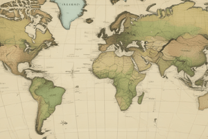
Mercator Projection
Mercator Projection
Focuses on longitude and latitude, maintains accurate direction, but distorts country size and location.
Goode Homolosine Projection
Goode Homolosine Projection
An interrupted map projection that minimizes distortion by removing parts of the globe, showing true size and shape but distorting distance and direction.
Fuller Map Projection
Fuller Map Projection
A map projection showing accurate size and shape of land masses, but hard to read due to the absence of cardinal directions.
Robinson Projection
Robinson Projection
Signup and view all the flashcards
Winkel Tripel Projection
Winkel Tripel Projection
Signup and view all the flashcards
Gall-Peters Projection
Gall-Peters Projection
Signup and view all the flashcards
Reference Map
Reference Map
Signup and view all the flashcards
Topographic Map
Topographic Map
Signup and view all the flashcards
Absolute Direction
Absolute Direction
Signup and view all the flashcards
Absolute Distance
Absolute Distance
Signup and view all the flashcards
Absolute Location
Absolute Location
Signup and view all the flashcards
Relative Direction
Relative Direction
Signup and view all the flashcards
Relative Distance
Relative Distance
Signup and view all the flashcards
Relative Location
Relative Location
Signup and view all the flashcards
Thematic Maps
Thematic Maps
Signup and view all the flashcards
Choropleth Maps
Choropleth Maps
Signup and view all the flashcards
Small-scale Maps
Small-scale Maps
Signup and view all the flashcards
Large-scale Maps
Large-scale Maps
Signup and view all the flashcards
Dot Density Map
Dot Density Map
Signup and view all the flashcards
Isoline Map
Isoline Map
Signup and view all the flashcards
Study Notes
Maps
- Mercator Projection focuses on longitude and latitude, maintaining accurate direction but distorting country size and location.
- All maps involve distortion, affecting direction, shape, area, and distance.
- Goode Homolosine projection is an interrupted map that minimizes distortion by removing portions of the globe, accurately shows size and shape while distorting distance and direction.
- Fuller map projection accurately shows size and shape but is hard to read due to the absence of cardinal directions.
- Robinson projection has distortion at the poles but accurately shows the size and shape of land masses.
- Winkle Tripel Projection resembles the Robinson projection but is rounder and larger, with the most distortion occurring at the poles.
- Gall Peters Projection accurately shows the true size of land masses but distorts direction and land shape.
- Reference maps are informational, indicating boundaries, place names, and geographic features of an area, such as public transportation maps.
Map Types and Data
- Topographic maps use contour lines to represent terrain and elevation.
- Absolute direction refers to the exact direction of a heading.
- Absolute distance is the precise measurement between two locations, typically in miles or kilometers.
- Absolute location pinpoints the exact spot, often expressed as GPS coordinates.
- Relative direction depends on the surrounding area.
- Relative distance is an approximate measurement between two places, often in terms of time or direction.
- Relative location describes a location using nearby geographic features.
- Thematic maps display spatial patterns and utilize quantitative data about specific topics.
- Choropleth maps present data using color, which involves generalizations.
- Small-scale maps represent a large portion of Earth's surface but include less detailed data.
- Large-scale maps represent a smaller portion of Earth's surface with more detailed data.
- Dot density maps use points to show data occurrence, indicating spatial distribution, but can be confusing if data is clustered.
- Isoline maps use lines to connect areas with similar or equal amounts of data, often used in weather maps.
- Cartogram maps represent data through the size of an area.
- Flowline maps illustrate the movement of goods, animals, people, or ideas between places.
Geographic Data and Tools
- Remote sensing involves gathering data about Earth's surface using satellites.
- Geographic Information System (GIS) is a computer system used to collect, analyze, and display geographic data.
- Global Positioning System (GPS) is a satellite network that determines the location of objects on Earth.
- Field observations involve gathering information firsthand, which is valuable for obtaining accurate and feasible data.
- Travel narratives reveal perceptions of places from individuals, providing an unfiltered perspective.
- Government documents show how land is being used.
- Landscape analysis reveals how people impact a landscape.
- Photo analysis shows culture, demographics, population density, and activities within a place.
- Qualitative data is presented in word form and is open to interpretation, such as presidential approval ratings.
- Quantitative data is numerical and can be counted and presented in number form, such as population numbers.
Application of Geographic Data
- Local governments utilize data to decide where to build schools and to determine land zoning.
- Regional governments use data for determining voting districts and allocating funding.
- National governments use data to set laws, change tax policies, and allocate federal funding.
- Local scale businesses utilize zoning and census data to determine store locations and gather consumer information.
- Regional scale businesses compare sales across different store locations and analyze tax rates.
- National scale businesses assess country tax rates, environmental standards, and employment laws to determine production costs.
Spatial Concepts
- Distance decay is the effect of distance on cultural or spatial interactions where greater distance results in less interaction.
- Supply chain is a network involving people, resources, and activities that creates and sells products, often with countries providing raw materials at the base.
- Time-space compression reduces the time it takes to move something from one location to another, counteracting distance decay.
- Spatial association is the relationship between different objects in an area, including their arrangement and connectivity.
- Spatial distribution refers to the density, concentration, and patterns in a place.
- Physical characteristics are natural Earth-made elements such as rivers, mountains, vegetation, and climate.
- Human characteristics are human-controlled aspects like religion, language, population, and demographic data.
- Sense of place is a strong feeling or perception people have of a location.
- Placelessness is when a place lacks unique characteristics, failing to evoke strong responses from individuals.
- Site factors are the characteristics of a specific location.
- Situation factors are the locations surrounding a place and the connections between locations.
Human-Environment Interaction
- Desalination is the process of removing salt from seawater.
- Environmental possibilism is the concept that the environment sets limits, but humans can adjust/modify it to overcome restrictions.
- Environmental determinism is the environment sets the possibilities for humans and society
- Human-environment interaction focuses on how people shape the environment and vice versa.
- Land use is how land has been modified for a specific purpose or task.
- Agricultural land is used for producing food for humans or animals.
- Industrial land used for manufacturing products.
- Commercial land for selling goods and services.
- Residential land for housing.
- Recreational land for leisure activities.
- Transportation land for roads, railroads, and airports.
- Sustainability involves using Earth's resources in ways that ensure their availability in the future.
Regional Analysis
- A region is a geographic area sharing common characteristics.
- Formal regions have common attributes defined by economic, social, political, or environmental traits, often clearly visible and easy to identify.
- Functional regions are structured around a central node, often based on economic activities, travel, or communication.
- Perceptual/vernacular regions lack precise definitions and are based on beliefs, feelings, and attitudes.
Studying That Suits You
Use AI to generate personalized quizzes and flashcards to suit your learning preferences.