Podcast
Questions and Answers
Concerning the formation of mountain ranges, which orogenic process primarily involves the isostatic adjustment following significant crustal thickening due to compressional forces, leading to large-scale uplift and subsequent erosion?
Concerning the formation of mountain ranges, which orogenic process primarily involves the isostatic adjustment following significant crustal thickening due to compressional forces, leading to large-scale uplift and subsequent erosion?
- Subduction-related volcanism and arc accretion.
- Mantle plume upwelling and associated lithospheric doming.
- Extension-driven block faulting and basin formation.
- Continental collision and subsequent crustal shortening. (correct)
The formation of rift valleys is exclusively attributed to tensional forces within the Earth's crust, precluding any influence from compressional or shear stresses in their development.
The formation of rift valleys is exclusively attributed to tensional forces within the Earth's crust, precluding any influence from compressional or shear stresses in their development.
False (B)
Elaborate on the role of differential erosion in shaping the morphology of plateau landscapes, specifically considering the variations in lithological resistance and structural controls.
Elaborate on the role of differential erosion in shaping the morphology of plateau landscapes, specifically considering the variations in lithological resistance and structural controls.
Differential erosion sculpts plateaus by exploiting variations in rock resistance and structural features, creating mesas, buttes, and canyons. Resistant layers cap less resistant strata, influencing erosion rates and landscape evolution.
The episodic effusive activity of shield volcanoes, such as Mauna Loa, is primarily driven by the low viscosity of ______ lavas, resulting in the formation of broad, gently sloping volcanic edifices.
The episodic effusive activity of shield volcanoes, such as Mauna Loa, is primarily driven by the low viscosity of ______ lavas, resulting in the formation of broad, gently sloping volcanic edifices.
Match the following desert types with their primary formation mechanisms:
Match the following desert types with their primary formation mechanisms:
Which of the following factors exerts the most significant control on the rate and pattern of sediment deposition within a deltaic environment, leading to the progradation or retrogradation of the deltaic plain?
Which of the following factors exerts the most significant control on the rate and pattern of sediment deposition within a deltaic environment, leading to the progradation or retrogradation of the deltaic plain?
The formation of oceanic islands exclusively results from volcanic activity at hotspots or mid-ocean ridges, with no contribution from tectonic uplift or sedimentary accretion processes.
The formation of oceanic islands exclusively results from volcanic activity at hotspots or mid-ocean ridges, with no contribution from tectonic uplift or sedimentary accretion processes.
Describe the interplay between eustatic sea-level changes and isostatic rebound in shaping the coastal geomorphology of formerly glaciated continental islands.
Describe the interplay between eustatic sea-level changes and isostatic rebound in shaping the coastal geomorphology of formerly glaciated continental islands.
The formation of hanging valleys is primarily a result of differential erosion by tributary glaciers that are ______ than the main trunk glacier, leaving them elevated above the main valley floor.
The formation of hanging valleys is primarily a result of differential erosion by tributary glaciers that are ______ than the main trunk glacier, leaving them elevated above the main valley floor.
Match each mountain range to its primary tectonic setting:
Match each mountain range to its primary tectonic setting:
In the context of volcanic landforms, what critical factor differentiates the eruptive behavior of stratovolcanoes from that of shield volcanoes, influencing the overall geomorphological expression and associated volcanic hazards?
In the context of volcanic landforms, what critical factor differentiates the eruptive behavior of stratovolcanoes from that of shield volcanoes, influencing the overall geomorphological expression and associated volcanic hazards?
Desert landscapes are exclusively shaped by aeolian processes, with fluvial and chemical weathering processes playing negligible roles in their geomorphological evolution.
Desert landscapes are exclusively shaped by aeolian processes, with fluvial and chemical weathering processes playing negligible roles in their geomorphological evolution.
Explain the concept of avulsion in deltaic systems, detailing the processes that trigger channel abandonment and the subsequent redistribution of sediment across the delta plain.
Explain the concept of avulsion in deltaic systems, detailing the processes that trigger channel abandonment and the subsequent redistribution of sediment across the delta plain.
The formation of atoll islands is fundamentally linked to the subsidence of volcanic islands and the concurrent upward growth of ______ reefs, maintaining their position near sea level.
The formation of atoll islands is fundamentally linked to the subsidence of volcanic islands and the concurrent upward growth of ______ reefs, maintaining their position near sea level.
Match the following valley types with their primary mode of formation:
Match the following valley types with their primary mode of formation:
Which of the following processes is most directly responsible for the development of stepped topography (e.g., terraces) along the flanks of mountains formed by tectonic uplift?
Which of the following processes is most directly responsible for the development of stepped topography (e.g., terraces) along the flanks of mountains formed by tectonic uplift?
The presence of extensive calcrete deposits in desert environments indicates a predominantly humid climate regime with high precipitation rates throughout the geological past.
The presence of extensive calcrete deposits in desert environments indicates a predominantly humid climate regime with high precipitation rates throughout the geological past.
Explain the concept of isostatic equilibrium and its role in controlling the elevation of mountain ranges over geological timescales.
Explain the concept of isostatic equilibrium and its role in controlling the elevation of mountain ranges over geological timescales.
The distinctive 'inverted topography' observed in some plateau regions is primarily a result of the preferential erosion of surrounding ______ rock, leaving more resistant features standing high.
The distinctive 'inverted topography' observed in some plateau regions is primarily a result of the preferential erosion of surrounding ______ rock, leaving more resistant features standing high.
Match the island type with its primary mode of origination.
Match the island type with its primary mode of origination.
Flashcards
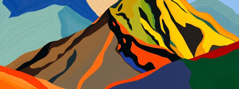
Mountains
Mountains
Large hills with steep sides, formed when earth pieces collide, taking millions of years to form.
Valleys
Valleys
Low spaces between hills or mountains, created by rivers flowing between them.
Plateaus
Plateaus
A large area of tall land with a mostly flat top, formed by erosion or magma swells.
Volcanoes
Volcanoes
Signup and view all the flashcards
Deserts
Deserts
Signup and view all the flashcards
Deltas
Deltas
Signup and view all the flashcards
Islands
Islands
Signup and view all the flashcards
Study Notes
- Landforms are natural features of the Earth's surface.
Mountains
- Large hills with steep sides are mountains.
- Mountains form over millions of years when large pieces of the Earth collide and force the earth upwards.
- Examples include the Rockies, Himalayas, Andes, and Alps.
Valleys
- Low spaces between two hills or mountains form valleys.
- Rivers flowing between hills and mountains create valleys.
- Valley types include river, glacial, rift, and hanging valleys.
Plateaus
- Large areas of tall land with a mostly flat top are plateaus.
- Plateaus form through mountain erosion or when magma swells below the Earth's surface.
- Examples include Altiplano (Peru), Colorado (Grand Canyon), and Deccan (India).
Volcanoes
- Volcanoes are mountains that erupt, allowing molten earth ("lava") to flow out.
- Multiple eruptions over time create a volcano.
- Examples include Mt. Fuji, Mauna Lee, Mt. Vesuvius, Krakatoa, and St. Helens.
Deserts
- Deserts are land areas where more water evaporates into the air than returns through precipitation.
- Living conditions are hostile for plant and animal life in deserts.
- Examples include the Sahara, Gobi, Mojave, and Arctic deserts.
Deltas
- Deltas are found at the edge of rivers where they meet the ocean.
- The flow of dirt and other sediment forms a triangle piece of land at the mouth of a river to create deltas.
- Examples include the Nile, Mississippi, and Ganges deltas.
Islands
- A piece of land surrounded by water on all sides is an island.
- Islands form when cooled lava, dirt, sand, and coral build up, or when a larger piece of land breaks off.
- Island types include continental, oceanic, desert, artificial, atoll, and coral.
Studying That Suits You
Use AI to generate personalized quizzes and flashcards to suit your learning preferences.


