Podcast
Questions and Answers
Which factors can be considered sources of error in surveying?
Which factors can be considered sources of error in surveying?
- Only human errors and instrument errors
- Human errors, environmental factors, and more (correct)
- Environmental factors and data processing techniques
- Only instrument errors and environmental factors
What is a primary application of surveying in construction?
What is a primary application of surveying in construction?
- Determining building locations and dimensions (correct)
- Designing legal property agreements
- Attesting to the accuracy of survey profiles
- Creating maps for geographic information systems
Why is accuracy critical in surveying?
Why is accuracy critical in surveying?
- To comply with international surveying standards
- To reduce survey costs significantly
- To minimize the time spent on surveying tasks
- To avoid conflicts and protect legal rights (correct)
What challenge does modern surveying face due to technology?
What challenge does modern surveying face due to technology?
Who must attest to the accuracy of survey information for legal validity?
Who must attest to the accuracy of survey information for legal validity?
What is the primary purpose of surveying?
What is the primary purpose of surveying?
Which type of surveying focuses on establishing property boundaries?
Which type of surveying focuses on establishing property boundaries?
What is a significant advantage of modern surveying techniques?
What is a significant advantage of modern surveying techniques?
Which instrument is primarily used for measuring horizontal and vertical angles?
Which instrument is primarily used for measuring horizontal and vertical angles?
What differentiates accuracy from precision in surveying?
What differentiates accuracy from precision in surveying?
Which surveying technique uses aerial photographs to create models of the earth's surface?
Which surveying technique uses aerial photographs to create models of the earth's surface?
Which of the following is NOT a type of surveying mentioned?
Which of the following is NOT a type of surveying mentioned?
What function does a level perform in surveying?
What function does a level perform in surveying?
Flashcards
What is surveying?
What is surveying?
The process of determining the three-dimensional position of points on Earth's surface and the features on the surface.
What are the main tasks of surveying?
What are the main tasks of surveying?
It involves measuring distances, angles, and elevations to create accurate representations of the land.
What does land surveying focus on?
What does land surveying focus on?
Establishing property boundaries, creating property maps, and determining the layout of land.
What is the purpose of construction surveying?
What is the purpose of construction surveying?
Signup and view all the flashcards
What does hydrographic surveying do?
What does hydrographic surveying do?
Signup and view all the flashcards
What does topographic surveying do?
What does topographic surveying do?
Signup and view all the flashcards
What does traditional surveying rely on?
What does traditional surveying rely on?
Signup and view all the flashcards
What is modern surveying?
What is modern surveying?
Signup and view all the flashcards
Instrument Errors
Instrument Errors
Signup and view all the flashcards
Human Errors
Human Errors
Signup and view all the flashcards
Environmental Factors
Environmental Factors
Signup and view all the flashcards
Legal Requirements of Surveying
Legal Requirements of Surveying
Signup and view all the flashcards
Licensed Surveyors
Licensed Surveyors
Signup and view all the flashcards
Study Notes
Introduction to Surveying
- Surveying is the process of determining the three-dimensional position of points on Earth's surface and the features on the surface.
- It's a fundamental discipline in various fields including construction, engineering, and mapping.
- Surveying involves measuring distances, angles, and elevations.
- The purpose of surveying is to create accurate representations or maps of the land.
Types of Surveying
- Land Surveying: Focuses on establishing property boundaries, creating property maps, and determining the layout of land.
- Construction Surveying: Provides precise measurements for construction projects ensuring alignment and accuracy.
- Hydrographic Surveying: Measures depths and contours of water bodies mapping the sea floor and water navigation channels.
- Topographic Surveying: Creates detailed representations of the natural and man-made features on the earth's surface, including elevations, contours, and details like buildings.
- Route Surveying: Focuses on the alignment and dimensions of transportation lines like roadways and railways.
Surveying Techniques
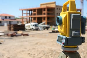
- Traditional Surveying: Uses instruments like total stations, theodolites, and levels.
- Modern Surveying: Employs GPS and other satellite-based technologies for greater speed and accuracy, sometimes called Geomatics.
- Photogrammetry: Uses aerial photographs to create 2D and 3D models of the earth's surface.
Instruments Used in Surveying
- Total Stations: Electronic instruments combining a theodolite for angles and a distance measurement device, offering both angular and linear measurements on the same device.
- Theodolites: Precise instruments that measure horizontal and vertical angles used for angular measurements.
- Levels: Used to determine elevations and differences in elevation between points.
- GPS (Global Positioning System): Sophisticated satellite navigation system that determines locations precisely using signals from satellites.
- UAV (Unmanned Aerial Vehicles): Drones equipped with cameras and other sensors to capture images and data for surveying applications.
Accuracy and Precision in Surveying
- Accuracy refers to the closeness of a measured value to the true value.
- Precision refers to the consistency or repeatability of measurements.
- Surveying requires a high degree of both accuracy and precision, ensuring the data collected can be relied upon.
- Sources of error include instrument errors, human errors, environmental factors, and more.
Applications of Surveying
- Construction: Determining building locations, alignment, and accurate dimensions.
- Engineering: Designing roads, bridges, tunnels, and other infrastructure projects.
- Mapping and GIS: Creating accurate maps, and databases for geographic information systems (GIS).
- Property Boundaries: Defining and establishing property lines.
Legal Aspects of Surveying
- Surveys are often legally required to comply with regulations and local laws.
- Licensed professionals must attest to the information accuracy, ensuring legal validity in documents like title deeds and land records.
- Accuracy of surveys is critical to avoid conflicts and to protect legal rights.
Challenges in Modern Surveying
- Rapid changes in technology require continuous skill development to utilize new software and hardware.
- Ensuring data accuracy amid rapid urbanization, construction, and environmental changes requires meticulous work.
- Processing vast amounts of data from technologies such as LiDAR or high-resolution imagery adds to the challenges.
Studying That Suits You
Use AI to generate personalized quizzes and flashcards to suit your learning preferences.