Podcast
Questions and Answers
Which mountain range is the source of many rivers in India?
Which mountain range is the source of many rivers in India?
- The Western Ghats
- The Himalayas (correct)
- The Vindhya Range
- The Eastern Ghats
What is the characteristic of the climate in the coastal regions of India?
What is the characteristic of the climate in the coastal regions of India?
- Humid (correct)
- Cold and humid
- Dry and snowy
- Hot and dry
Which of the following is NOT a type of natural resource found in India?
Which of the following is NOT a type of natural resource found in India?
- Water Resources
- Minerals
- Forest Resources
- Oil (correct)
What is the name of the second-longest river in India?
What is the name of the second-longest river in India?
How many seasons does India experience?
How many seasons does India experience?
What is the latitude range of India's location?
What is the latitude range of India's location?
Which of the following is NOT a physical division of India?
Which of the following is NOT a physical division of India?
Which mountain range is known for its high peaks and glaciers?
Which mountain range is known for its high peaks and glaciers?
What is the longest river in India?
What is the longest river in India?
Which river flows from the Himalayas to the Arabian Sea?
Which river flows from the Himalayas to the Arabian Sea?
Which of the following is a characteristic of the Indian Desert?
Which of the following is a characteristic of the Indian Desert?
What is the name of the plateau region in India?
What is the name of the plateau region in India?
Which of the following islands is located in the Bay of Bengal?
Which of the following islands is located in the Bay of Bengal?
Flashcards are hidden until you start studying
Study Notes
Location and Extent
- India is located in the southern part of Asia, between 8°4' and 37°6' north latitude and 68°7' and 97°25' east longitude.
- It is bounded by the Himalayan mountain range in the north, the Indian Ocean in the south, the Bay of Bengal in the east, and the Arabian Sea in the west.
Physical Divisions
- India can be divided into six physical divisions:
- The Himalayan Mountains: The highest mountain range in India, with an average elevation of 6,000 meters.
- The Indo-Gangetic Plain: A vast fertile plain stretching from the Himalayas to the Vindhya range, formed by the Indus and Ganges rivers.
- The Peninsular Plateau: A tableland region comprising the Deccan Plateau and the Chhota Nagpur Plateau.
- The Indian Desert: A region of arid climate and low rainfall, covering parts of Rajasthan and Gujarat.
- The Coastal Plains: Narrow strips of land along the Arabian Sea and the Bay of Bengal.
- The Islands: The Andaman and Nicobar Islands in the Bay of Bengal and the Lakshadweep Islands in the Arabian Sea.
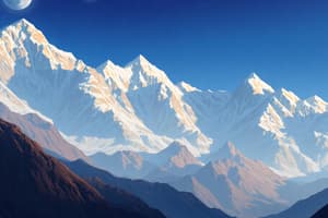
Mountains
- The Himalayas: The Himalayan range is divided into three parallel ranges: the Great Himalayas, the Middle Himalayas, and the Outer Himalayas.
- The Karakoram Range: A mountain range located in the Trans-Himalayan region, known for its high peaks and glaciers.
- The Eastern Ghats: A discontinuous range of mountains along the eastern coast of India.
- The Western Ghats: A continuous range of mountains along the western coast of India, known for its biodiversity and scenic beauty.
Rivers
- The Ganges River: The longest river in India, flowing from the Himalayas to the Bay of Bengal.
- The Indus River: The westernmost river in India, flowing from the Himalayas to the Arabian Sea.
- The Brahmaputra River: A river flowing from the Himalayas to the Bay of Bengal, known for its massive floodplains.
- The Godavari River: The second-longest river in India, flowing from the Western Ghats to the Bay of Bengal.
Climate
- Tropical Climate: India has a tropical climate, with high temperatures and high humidity throughout the year.
- Seasonal Variations: India experiences four seasons: winter, summer, monsoon, and post-monsoon.
- Regional Variations: Climate varies from region to region, with the Himalayas having a cold climate, the deserts having a hot and dry climate, and the coastal regions having a humid climate.
Natural Resources
- Minerals: India is rich in minerals such as iron ore, coal, manganese, and chromium.
- Water Resources: India has a vast network of rivers, lakes, and wetlands, with the Himalayas being the source of many rivers.
- Forest Resources: India has a significant amount of forest cover, with the Western Ghats and the Eastern Ghats being biodiversity hotspots.
Location and Extent
- India is located between 8°4' and 37°6' north latitude and 68°7' and 97°25' east longitude.
- The country is bounded by the Himalayan mountain range in the north, the Indian Ocean in the south, the Bay of Bengal in the east, and the Arabian Sea in the west.
Physical Divisions
- India can be divided into six physical divisions: The Himalayan Mountains, The Indo-Gangetic Plain, The Peninsular Plateau, The Indian Desert, The Coastal Plains, and The Islands.
- The Himalayan Mountains have an average elevation of 6,000 meters.
- The Indo-Gangetic Plain is a vast fertile plain stretching from the Himalayas to the Vindhya range, formed by the Indus and Ganges rivers.
- The Peninsular Plateau comprises the Deccan Plateau and the Chhota Nagpur Plateau.
Mountains
- The Himalayas are divided into three parallel ranges: the Great Himalayas, the Middle Himalayas, and the Outer Himalayas.
- The Karakoram Range is a mountain range located in the Trans-Himalayan region, known for its high peaks and glaciers.
- The Eastern Ghats and the Western Ghats are mountain ranges along the eastern and western coasts of India respectively.
Rivers
- The Ganges River is the longest river in India, flowing from the Himalayas to the Bay of Bengal.
- The Indus River is the westernmost river in India, flowing from the Himalayas to the Arabian Sea.
- The Brahmaputra River flows from the Himalayas to the Bay of Bengal, known for its massive floodplains.
- The Godavari River is the second-longest river in India, flowing from the Western Ghats to the Bay of Bengal.
Climate
- India has a tropical climate, with high temperatures and high humidity throughout the year.
- The country experiences four seasons: winter, summer, monsoon, and post-monsoon.
- Climate varies from region to region, with the Himalayas having a cold climate, the deserts having a hot and dry climate, and the coastal regions having a humid climate.
Natural Resources
- India is rich in minerals such as iron ore, coal, manganese, and chromium.
- The country has a vast network of rivers, lakes, and wetlands, with the Himalayas being the source of many rivers.
- India has a significant amount of forest cover, with the Western Ghats and the Eastern Ghats being biodiversity hotspots.
Studying That Suits You
Use AI to generate personalized quizzes and flashcards to suit your learning preferences.