Podcast
Questions and Answers
What are the two types of states that existed in India before 1947?
What are the two types of states that existed in India before 1947?
Provinces and Princely states.
How does India’s geographical position influence its relationships with its southern neighbors?
How does India’s geographical position influence its relationships with its southern neighbors?
India's strategic position enhances its historical and geographical links with Sri Lanka and Maldives.
What are the architectural influences noted in India from other regions?
What are the architectural influences noted in India from other regions?
Greek sculpture and dome and minaret styles from West Asia.
What is the purpose of the Bhuvan portal mentioned in the context?
What is the purpose of the Bhuvan portal mentioned in the context?
How many states and Union Territories does India have?
How many states and Union Territories does India have?
What method of geographical division does the Tropic of Cancer represent in India?
What method of geographical division does the Tropic of Cancer represent in India?
What are the two groups of islands located southeast and southwest of India?
What are the two groups of islands located southeast and southwest of India?
What catastrophic event caused 'Indira Point' to be submerged in 2004?
What catastrophic event caused 'Indira Point' to be submerged in 2004?
What is the area of land mass that India covers in square kilometers?
What is the area of land mass that India covers in square kilometers?
Between which latitudes does India extend?
Between which latitudes does India extend?
Which hemisphere does India lie entirely in?
Which hemisphere does India lie entirely in?
How has India progressed in various fields over the last five decades?
How has India progressed in various fields over the last five decades?
What percentage of the total geographical area does the content refer to?
What percentage of the total geographical area does the content refer to?
Which oceans are represented in the geographical layout that includes prominent continents?
Which oceans are represented in the geographical layout that includes prominent continents?
Name the two major continents located in the Northern Hemisphere as depicted in the layout.
Name the two major continents located in the Northern Hemisphere as depicted in the layout.
Which continent is positioned south of North America and east of the Pacific Ocean?
Which continent is positioned south of North America and east of the Pacific Ocean?
Identify the continent represented directly south of Europe.
Identify the continent represented directly south of Europe.
What is the latitude of Antarctica as shown in the figure?
What is the latitude of Antarctica as shown in the figure?
Which continent can be found directly to the east of Africa in this layout?
Which continent can be found directly to the east of Africa in this layout?
What key feature indicates the separation of Eastern and Western Hemispheres in the figure?
What key feature indicates the separation of Eastern and Western Hemispheres in the figure?
Which continent is located entirely in the Southern Hemisphere according to the layout?
Which continent is located entirely in the Southern Hemisphere according to the layout?
What has historically limited India's maritime interactions compared to its land routes?
What has historically limited India's maritime interactions compared to its land routes?
Which states of India share borders with Pakistan?
Which states of India share borders with Pakistan?
How did ancient trade routes contribute to the exchange of ideas in India?
How did ancient trade routes contribute to the exchange of ideas in India?
Name the countries that share land boundaries with India in the north.
Name the countries that share land boundaries with India in the north.
Which Indian Union Territory is the smallest by area?
Which Indian Union Territory is the smallest by area?
Identify the largest state in India by area.
Identify the largest state in India by area.
What is the significance of 82°30'E as the Standard Meridian of India?
What is the significance of 82°30'E as the Standard Meridian of India?
List the four groups of states that share common frontiers with neighboring countries.
List the four groups of states that share common frontiers with neighboring countries.
Describe how India's geographical location affects its strategic importance.
Describe how India's geographical location affects its strategic importance.
What types of products were historically taken from India to other countries?
What types of products were historically taken from India to other countries?
What ancient texts and stories contributed to India's cultural exchange with other civilizations?
What ancient texts and stories contributed to India's cultural exchange with other civilizations?
Why is the difference in the duration of day and night noticeable in Kashmir but hardly felt in Kanniyakumari?
Why is the difference in the duration of day and night noticeable in Kashmir but hardly felt in Kanniyakumari?
What geographical features have facilitated ancient travel to and from India?
What geographical features have facilitated ancient travel to and from India?
How does the latitudinal extent of India influence climatic variations across the country?
How does the latitudinal extent of India influence climatic variations across the country?
What is the total length of India's coastline, and why is it significant?
What is the total length of India's coastline, and why is it significant?
Explain how India's geographical features contribute to its division of seas.
Explain how India's geographical features contribute to its division of seas.
Why is India's long coastline considered beneficial for international relations?
Why is India's long coastline considered beneficial for international relations?
What impact did the opening of the Suez Canal have on India's trade distance from Europe?
What impact did the opening of the Suez Canal have on India's trade distance from Europe?
How does India's geographical location contribute to its biodiversity?
How does India's geographical location contribute to its biodiversity?
Discuss the role of the Indian Ocean in shaping India's economy.
Discuss the role of the Indian Ocean in shaping India's economy.
Flashcards
India's Location
India's Location
India is a vast country located entirely in the Northern Hemisphere.
Tropic of Cancer's Impact on India
Tropic of Cancer's Impact on India
The Tropic of Cancer divides India into two almost equal parts.
Andaman and Nicobar Islands' Location
Andaman and Nicobar Islands' Location
The Andaman and Nicobar Islands lie in the Bay of Bengal to the southeast of mainland India.
Lakshadweep Islands' Location
Lakshadweep Islands' Location
Signup and view all the flashcards
Indira Point's Fate
Indira Point's Fate
Signup and view all the flashcards
India's Size
India's Size
Signup and view all the flashcards
India's Recent Progress
India's Recent Progress
Signup and view all the flashcards
India's Southern Neighbors
India's Southern Neighbors
Signup and view all the flashcards
Types of States in India Before 1947
Types of States in India Before 1947
Signup and view all the flashcards
Palk Strait
Palk Strait
Signup and view all the flashcards
School Bhuvan
School Bhuvan
Signup and view all the flashcards
Signup and view all the flashcards
Longitude
Longitude
Signup and view all the flashcards
Latitude
Latitude
Signup and view all the flashcards
Continent
Continent
Signup and view all the flashcards
Ocean
Ocean
Signup and view all the flashcards
Location
Location
Signup and view all the flashcards
Geography
Geography
Signup and view all the flashcards
Geographical Area
Geographical Area
Signup and view all the flashcards
Relative Location
Relative Location
Signup and view all the flashcards
World Map
World Map
Signup and view all the flashcards
Standard Meridian
Standard Meridian
Signup and view all the flashcards
Mountain Passes
Mountain Passes
Signup and view all the flashcards
Land Routes
Land Routes
Signup and view all the flashcards
Upanishads and Ramayana
Upanishads and Ramayana
Signup and view all the flashcards
Indian Numerals and Decimal System
Indian Numerals and Decimal System
Signup and view all the flashcards
Spices, Muslin, and Merchandise
Spices, Muslin, and Merchandise
Signup and view all the flashcards
International Trade and Commerce
International Trade and Commerce
Signup and view all the flashcards
Extent of a Country
Extent of a Country
Signup and view all the flashcards
Union Territories
Union Territories
Signup and view all the flashcards
States Sharing International Borders
States Sharing International Borders
Signup and view all the flashcards
What is the Standard Meridian of India?
What is the Standard Meridian of India?
Signup and view all the flashcards
Why is there a time lag across India?
Why is there a time lag across India?
Signup and view all the flashcards
Why is India's location important globally?
Why is India's location important globally?
Signup and view all the flashcards
Why is India's location in the Indian Ocean important?
Why is India's location in the Indian Ocean important?
Signup and view all the flashcards
How does latitude affect day and night durations in India?
How does latitude affect day and night durations in India?
Signup and view all the flashcards
How does India's location benefit trade?
How does India's location benefit trade?
Signup and view all the flashcards
How did the Suez Canal affect India?
How did the Suez Canal affect India?
Signup and view all the flashcards
How does India's location benefit politically?
How does India's location benefit politically?
Signup and view all the flashcards
How does India's location relate to Asia?
How does India's location relate to Asia?
Signup and view all the flashcards
Why is the difference between day and night durations hardly felt at Kanniyakumari, but prominent in Kashmir?
Why is the difference between day and night durations hardly felt at Kanniyakumari, but prominent in Kashmir?
Signup and view all the flashcards
Study Notes
India - Size and Location
- India is one of the oldest civilizations, experiencing significant socio-economic progress in the last five decades.
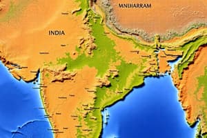
- India's landmass lies completely in the Northern Hemisphere, between latitudes 8°4'N and 37°6'N, and longitudes 68°7'E and 97°25'E.
- The Tropic of Cancer (23°30'N) divides the country nearly equally.
- The Andaman and Nicobar Islands lie southeast of the mainland and Lakshwadeep Islands southwest in the Bay of Bengal and Arabian Sea, respectively.
- Indira Point, the southernmost point of India, was submerged in the 2004 tsunami.
- India covers an area of 3.28 million square kilometers, representing 2.4% of the world's total geographical area.
- India's coastline, including the Andaman and Nicobar, and Lakshadweep Islands, measures approximately 7,516.6 kilometers.
- India is bordered by young fold mountains in the northwest, north, and northeast.
- Below 22° north latitude, India narrows, forming the Arabian Sea to the west and the Bay of Bengal to the east.
- The latitudinal extent impacts the duration of day and night, with variations from south to north.
- The Standard Meridian of India (82°30'E) is used for the standard time throughout the country, passing through Mirzapur (Uttar Pradesh).
- India's central location facilitates trade routes between East and West Asia.
- The Suez Canal reduces India's distance from Europe by 7,000 km (since 1869).
India in the World
- India is the seventh-largest country globally.
- India's land boundary is approximately 15,200 km.
Studying That Suits You
Use AI to generate personalized quizzes and flashcards to suit your learning preferences.