Podcast
Questions and Answers
What does a modern gravimeter rely on?
What does a modern gravimeter rely on?
- A mass pivoted on a beam attached to a spring (correct)
- A thermostat to prevent thermal contraction or extension (correct)
- Careful leveling before a reading is made (correct)
- All of the above (correct)
The data from a gravimeter is directly useful.
The data from a gravimeter is directly useful.
False (B)
Which of these is NOT a type of gravity correction?
Which of these is NOT a type of gravity correction?
- Drift
- Eötvös correction
- Topographic correction
- Longitude correction (correct)
Tidal affects are an example of a time dependent variation.
Tidal affects are an example of a time dependent variation.
Terrain effects are an example of a place dependent variation.
Terrain effects are an example of a place dependent variation.
What is the correction that must be applied to a gravity measurement due to the difference in Earth's radius at different elevations?
What is the correction that must be applied to a gravity measurement due to the difference in Earth's radius at different elevations?
What does drift refer to in gravity measurements?
What does drift refer to in gravity measurements?
Which of the following is NOT a method to correct drift in gravity measurements?
Which of the following is NOT a method to correct drift in gravity measurements?
What is the Eötvös correction used for?
What is the Eötvös correction used for?
A gravity measurement made on a westward moving object will have a higher measured gravity.
A gravity measurement made on a westward moving object will have a higher measured gravity.
What is the most limiting factor in aerial gravity surveys?
What is the most limiting factor in aerial gravity surveys?
Topographic corrections are necessary when gravity measurements are taken at different elevations.
Topographic corrections are necessary when gravity measurements are taken at different elevations.
What is the basic idea behind the free-air correction?
What is the basic idea behind the free-air correction?
What does the free-air correction typically amount to?
What does the free-air correction typically amount to?
What does the Bouguer correction take into account?
What does the Bouguer correction take into account?
What is the Bouguer correction typically based on?
What is the Bouguer correction typically based on?
What is the combined elevation correction?
What is the combined elevation correction?
The combined elevation correction is dependent on both elevation and rock density.
The combined elevation correction is dependent on both elevation and rock density.
Which of the following densities is typically used in the standard Bouguer anomaly calculation?
Which of the following densities is typically used in the standard Bouguer anomaly calculation?
What is the primary purpose of the Bouguer anomaly?
What is the primary purpose of the Bouguer anomaly?
The terrain correction is a simple correction that can be easily applied using a single formula.
The terrain correction is a simple correction that can be easily applied using a single formula.
What is the rule of thumb regarding terrain corrections?
What is the rule of thumb regarding terrain corrections?
What is the final result of applying all the gravity corrections?
What is the final result of applying all the gravity corrections?
The Bouguer anomaly is essentially the same as the Bouguer correction.
The Bouguer anomaly is essentially the same as the Bouguer correction.
Flashcards
What is the sensitivity of modern gravimeters?
What is the sensitivity of modern gravimeters?
A modern gravimeter can detect a change in gravity as small as 1/100,000,000th of the Earth's gravity or 0.01 mGal.
How do gravimeters work?
How do gravimeters work?
Gravimeters rely on a mass attached to a spring and pivoted on a beam. This system is affected by changes in gravity, which are measured by the movement of the mass.
Why is leveling important for gravimeter readings?
Why is leveling important for gravimeter readings?
Gravimeters need to be carefully leveled before a reading is taken, as any tilt can affect the measurement. This process can be time-consuming.
Why do gravimeter readings require corrections?
Why do gravimeter readings require corrections?
Signup and view all the flashcards
What is drift in gravimetry?
What is drift in gravimetry?
Signup and view all the flashcards
How is drift corrected in gravimetry?
How is drift corrected in gravimetry?
Signup and view all the flashcards
What is latitude correction in gravimetry?
What is latitude correction in gravimetry?
Signup and view all the flashcards
What is the Eötvös correction?
What is the Eötvös correction?
Signup and view all the flashcards
What is the free-air correction?
What is the free-air correction?
Signup and view all the flashcards
What is the Bouguer correction?
What is the Bouguer correction?
Signup and view all the flashcards
What is the terrain correction?
What is the terrain correction?
Signup and view all the flashcards
What is the Bouguer anomaly?
What is the Bouguer anomaly?
Signup and view all the flashcards
What is the complete Bouguer anomaly?
What is the complete Bouguer anomaly?
Signup and view all the flashcards
What is a base station in gravimetry?
What is a base station in gravimetry?
Signup and view all the flashcards
What is a looping procedure in gravimetry?
What is a looping procedure in gravimetry?
Signup and view all the flashcards
What are temporal variations in gravimetry?
What are temporal variations in gravimetry?
Signup and view all the flashcards
What are spatial variations in gravimetry?
What are spatial variations in gravimetry?
Signup and view all the flashcards
Why does gravity vary with latitude?
Why does gravity vary with latitude?
Signup and view all the flashcards
What is the International Gravity Formula?
What is the International Gravity Formula?
Signup and view all the flashcards
What is the standard Bouguer density?
What is the standard Bouguer density?
Signup and view all the flashcards
How are density profiles created in gravimetry?
How are density profiles created in gravimetry?
Signup and view all the flashcards
How do gamma-gamma density logs work?
How do gamma-gamma density logs work?
Signup and view all the flashcards
How do neutron density logs work?
How do neutron density logs work?
Signup and view all the flashcards
What is a borehole gravity meter?
What is a borehole gravity meter?
Signup and view all the flashcards
What is a datum elevation in gravimetry?
What is a datum elevation in gravimetry?
Signup and view all the flashcards
What is isostasy in gravimetry?
What is isostasy in gravimetry?
Signup and view all the flashcards
Study Notes
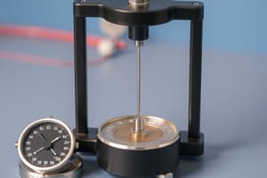
Modern Gravimeters
- Can detect a change of 1/100,000,000th g or 0.01 mGal.
- Rely on a mass pivoted on a beam attached to a spring.
- A thermostat prevents thermal contraction or expansion.
- Must be carefully leveled before a reading (time-consuming).
- Some models have automatic leveling.
- Are delicate and need protective transport.
- Data is not directly useful; needs reduction to correct for various effects.
- Gravity anomalies are small, so corrections are similarly sized and important.
Gravity Corrections
- Measurements at different elevations need correction because distance to Earth's center affects gravity.
- Corrections needed to analyze raw data for anomalies
- Drift: Changes in readings even without movement, often due to spring creep or diurnal variations that are corrected using base station readings.
- Latitude correction accounts for Earth's shape (oblateness) and latitude.
- Eötvös Correction: Accounts for centrifugal force due to Earth's rotation, important for moving objects (vehicles).
- Topographic corrections adjust for variations in altitude and terrain features (free-air and Bouguer corrections).
- Free-air correction: Accounts for changes in gravity with elevation.
- Bouguer correction: Accounts for the mass of the terrain above the measurement point.
- Temporal variations:
- Instrumental drift
- Tidal effects
- Latitude variations
- Elevation variations
- Slab effects
- Terrain effects
Drift
- Drift is a change in readings that can occur even with a stationary device.
- The spring inside the gravimeter can slowly creep or stretch.
- Drift is corrected by periodically returning to a base station to measure the drift rate.
- The drift is subtracted from the rest of the data.
Drift Example
- Temporal drift variations must be corrected for land-based surveys.
- Base station readings are used to normalize and subtract the temporal variations to account for drift.
Field Procedure
- Establish the location of one or more base stations (e.g., station 9625).
- Establish locations (numbered 158-163) for gravity stations to collect readings over the survey area.
- Record base station relative gravity readings and time.
- Collect relative gravity readings at each gravity station.
- Return to the base station every hour, taking final readings after the last station.
Causes of Tides
- The variations of gravity due to the motion of the Earth and the moon are corrected for and accounted for in the Gravity calculations.
Effects of Earth's Shape: Latitudinal Gravity Variations
- Gravity varies with latitude due to Earth's oblate spheroid shape.
- Least at the Equator, most at the Poles.
- Variation is about 0.5%.
- Earth's rotation causes centrifugal force larger at the equator than the poles and causes Earth to bulge outward.
- This produces a difference in the observed gravity between the equator and the poles.
Theoretical Gravity: Normal Ellipsoid, Latitude Correction
- Gravity varies with latitude, this correction is determined using the International Gravity Formula (usually called a theoretical gravity formula).
- The observed gravity must have the theoretical gravity subtracted from it to obtain the anomaly.
- The formula accounts for the Earth's shape and latitude.
- Corrections are ~0.8 mGal/km.
Eötvös Correction
- Necessary when gravity readings are taken from a moving object.
- Gravity measurements are affected by centrifugal acceleration induced by movement.
- Your weight reduction due to centrifugal force is about 0.34% at the equator because of rotation
Topographic Corrections
- Measure gravity at the same elevation for accuracy.
- Free-air and Bouguer corrections needed when elevations differ; these correct for variation due to Elevation changes or Mass variations.
Free-Air Correction
- Accounts for change in gravity with altitude.
- Gravimeter readings are corrected for variations due to elevation using the Free-Air correction.
- The correction is approximately 0.3086 mGal/meter of elevation change.
- Positive h = Mountain range, negative h = Valley.
Bouguer Correction
- Accounts for the mass of the terrain above the measurement point.
- The difference between the observed gravity and the calculated gravity based on a uniform density slab is the Bouguer Anomaly..
Combined Elevation Correction
- The free-air and Bouguer corrections can be combined into one.
- It calculates the total change in observed gravity due to both elevation and the mass of the terrain (using density).
Selecting Reduction Density
- Standard Bouguer density used for consistency across surveys.
- Field measurements or geologic maps (data tables) can also be used for selecting appropriate density.
Bouguer Terrain Correction
- Bouguer correction assumes an infinite slab, reasonable around C. The Bouguer correction should be used.
- Necessary when topography is present to account for the localized effect of mass.
- Terrain and density are relevant for corrections.
Finally... The Bouguer Anomaly
- After applying all previous corrections to the observed gravity readings, the result is called a "Bouguer Anomaly."
- The Bouguer Anomaly reflects density variations below a datum level, aside from the effects from topography and latitude.
Bouguer Anomaly of Egypt
- Example map of the Bouguer Anomaly of Egypt.
Studying That Suits You
Use AI to generate personalized quizzes and flashcards to suit your learning preferences.