Podcast
Questions and Answers
ما هو الغرض الرئيسي من التحليل المكاني؟
ما هو الغرض الرئيسي من التحليل المكاني؟
- إنشاء تطبيقات الويب التفاعلية
- تحسين النماذج الرياضية
- تحليل البيانات الجغرافية وإستخلاص معلومات مفيدة منها (correct)
- إنشاء خرائط جغرافية
ما هي أمثلة على تقنيات التحليل المكاني الشائعة الاستخدام؟
ما هي أمثلة على تقنيات التحليل المكاني الشائعة الاستخدام؟
- التحليل الشبكي والتحليل الفضائي (correct)
- التحليل الزمني والتحليل البصري
- التحليل الخطي والتحليل الإحصائي
- التحليل الحراري والتحليل الكهرومغناطيسي
ما الدور الرئيسي للتقنيات الخرائطية في نظم المعلومات الجغرافية؟
ما الدور الرئيسي للتقنيات الخرائطية في نظم المعلومات الجغرافية؟
- توفير تصورات بصرية سهلة الفهم للبيانات المجردة (correct)
- تطوير النماذج الرياضية المعقدة
- دعم عمليات اتخاذ القرار الإستراتيجية
- إنشاء وإدارة قواعد البيانات الجغرافية
ما هي بعض مجالات التطبيق الرئيسية لنظم المعلومات الجغرافية؟
ما هي بعض مجالات التطبيق الرئيسية لنظم المعلومات الجغرافية؟
ما هي أهمية نظم المعلومات الجغرافية في المستقبل؟
ما هي أهمية نظم المعلومات الجغرافية في المستقبل؟
Flashcards are hidden until you start studying
Study Notes
Geographic Information Systems (GIS): Exploring Geospatial Data, Spatial Analysis, and Mapping Technologies
Introduction
In our increasingly interconnected world, understanding the relationship between data points and their locations is becoming more important every day. Enterprises across sectors rely on geographic information systems (GIS) to gain insights, optimize operations, and plan strategically. GIS allows users to capture, store, check, and display data related to positions on Earth's surface, revealing valuable patterns, relationships, and trends.
Understanding GIS
GIS is a computer system designed to handle spatially referenced data, enabling sophisticated analyses that traditional databases cannot perform. This system integrates data from multiple sources to reveal patterns and correlations that occur only because of the data's spatial context. GIS technology has evolved significantly since its inception in the 1960s, and today it is an essential tool for businesses, governments, and academia alike.
GIS Subtopics
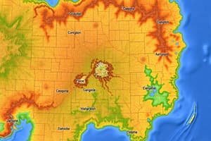
Geospatial Data
At the heart of GIS are high-quality, accurate, and up-to-date geospatial datasets. These datasets include everything from satellite imagery to street maps, GPS coordinates, and topographic data, among others. Ensuring the quality of these datasets is paramount, as errors or inconsistencies can lead to incorrect conclusions and decisions.
Spatial Analysis
Spatial analysis is the process of extracting useful information from geospatial datasets. With GIS, users can create models to predict future events, identify trends, and assess risks. Overlay analysis, moving window analysis, and network analysis are examples of techniques commonly employed in spatial data mining.
Mapping Technologies
Mapping technologies play a vital role in GIS, providing users with intuitive visualizations of otherwise abstract data. From simple maps to interactive web applications, mapping is a key aspect of GIS, allowing decision-makers to easily interpret and engage with spatial data.
GIS Applications
There are countless applications for GIS across industries, ranging from environmental conservation and disaster response to traffic management and property assessment. GIS can be used to analyze patterns, predict trends, and support informed decision-making across various domains.
In conclusion, GIS offers a powerful set of tools for analyzing geospatial data, revealing hidden patterns, and supporting strategic decision-making. As the importance of spatial analysis continues to grow, so too will the demand for skilled professionals with expertise in GIS.
Studying That Suits You
Use AI to generate personalized quizzes and flashcards to suit your learning preferences.