Podcast
Questions and Answers
What is the primary driving force behind the movement of tectonic plates?
What is the primary driving force behind the movement of tectonic plates?
- Gravitational pull from the sun and moon
- Changes in atmospheric pressure
- Convection currents in the Earth's mantle (correct)
- The Earth's magnetic field
Which type of plate boundary is characterized by the formation of new crustal material?
Which type of plate boundary is characterized by the formation of new crustal material?
- Subduction boundary
- Transform boundary
- Convergent boundary
- Divergent boundary (correct)
What geological process typically occurs at convergent plate boundaries where one plate is forced beneath another?
What geological process typically occurs at convergent plate boundaries where one plate is forced beneath another?
- Rifting
- Faulting
- Subduction (correct)
- Volcanic ridge formation
The presence of bituminous coal on all continents suggests what about Earth's past climates?
The presence of bituminous coal on all continents suggests what about Earth's past climates?
Glacial evidence in warm regions and coal deposits in cold regions provide evidence of what?
Glacial evidence in warm regions and coal deposits in cold regions provide evidence of what?
What type of boundary is the Mid-Atlantic Ridge an example of?
What type of boundary is the Mid-Atlantic Ridge an example of?
What is the lithosphere composed of?
What is the lithosphere composed of?
Which of the following locations is an example of a divergent boundary where crust is being pulled apart by convection?
Which of the following locations is an example of a divergent boundary where crust is being pulled apart by convection?
What effect does condensation typically have on the cooling rate of air?
What effect does condensation typically have on the cooling rate of air?
Which side of a landmass receives more precipitation due to the prevailing winds?
Which side of a landmass receives more precipitation due to the prevailing winds?
How does a maritime climate differ from a continental climate in terms of temperature range?
How does a maritime climate differ from a continental climate in terms of temperature range?
What is a characteristic precipitation pattern of a continental climate?
What is a characteristic precipitation pattern of a continental climate?
What is a key factor that influences the cooling of air?
What is a key factor that influences the cooling of air?
What is the primary factor that distinguishes a semi-continental climate from a fully continental one?
What is the primary factor that distinguishes a semi-continental climate from a fully continental one?
According to the provided information, what is the purpose of a climate graph?
According to the provided information, what is the purpose of a climate graph?
Which of the following is a characteristic of places with a maritime climate?
Which of the following is a characteristic of places with a maritime climate?
During which geological era did the Rocky Mountains complete their formation?
During which geological era did the Rocky Mountains complete their formation?
Which geological period is associated with the emergence of shallow seas and the formation of the Appalachian Mountains?
Which geological period is associated with the emergence of shallow seas and the formation of the Appalachian Mountains?
The first flowering plants appeared in which geological era?
The first flowering plants appeared in which geological era?
Which geological era is characterized by the dominance of humans and the age of mammals?
Which geological era is characterized by the dominance of humans and the age of mammals?
Continental drift suggests that Earth's continents were once part of a:
Continental drift suggests that Earth's continents were once part of a:
What geological event is associated with the Precambrian shields?
What geological event is associated with the Precambrian shields?
During which solstice is the sun directly overhead the Tropic of Capricorn?
During which solstice is the sun directly overhead the Tropic of Capricorn?
What is the main function of GPS, according to the provided text?
What is the main function of GPS, according to the provided text?
What does the acronym GIS stand for?
What does the acronym GIS stand for?
Which of the following time periods is the longest?
Which of the following time periods is the longest?
Flashcards
Tropic of Capricorn
Tropic of Capricorn
The point on Earth where the sun is directly overhead during the winter solstice. This occurs in the Southern Hemisphere.
GIS (Geographic Information System)
GIS (Geographic Information System)
A system used to record information on maps. It combines data layers to create comprehensive maps.
GPS (Global Positioning System)
GPS (Global Positioning System)
A system that uses satellites to determine the precise location of a point on Earth.
Era
Era
Signup and view all the flashcards
Cenozoic Era
Cenozoic Era
Signup and view all the flashcards
Mesozoic Era
Mesozoic Era
Signup and view all the flashcards
Paleozoic Era
Paleozoic Era
Signup and view all the flashcards
Precambrian Era
Precambrian Era
Signup and view all the flashcards
Continental Drift
Continental Drift
Signup and view all the flashcards
Pangaea
Pangaea
Signup and view all the flashcards
Bituminous Coal
Bituminous Coal
Signup and view all the flashcards
Plate Tectonics
Plate Tectonics
Signup and view all the flashcards
Lithosphere
Lithosphere
Signup and view all the flashcards
Divergent Boundaries
Divergent Boundaries
Signup and view all the flashcards
Subduction
Subduction
Signup and view all the flashcards
Convergent Boundaries
Convergent Boundaries
Signup and view all the flashcards
Mid-Atlantic Ridge
Mid-Atlantic Ridge
Signup and view all the flashcards
Relief
Relief
Signup and view all the flashcards
Windward Side
Windward Side
Signup and view all the flashcards
Leeward Side
Leeward Side
Signup and view all the flashcards
Maritime Climate
Maritime Climate
Signup and view all the flashcards
Continental Climate
Continental Climate
Signup and view all the flashcards
Semi-Continental Climate
Semi-Continental Climate
Signup and view all the flashcards
Climate Graph
Climate Graph
Signup and view all the flashcards
Adiabatic Cooling
Adiabatic Cooling
Signup and view all the flashcards
Study Notes
Geography Exam Study Notes
- Exam Focus: Focus on underlined headings. Starred concepts are unfamiliar.
- Compass Rules: Measured from North in a clockwise direction. Written as 3 figures (e.g., 095). Cardinal points: North, East, South, West. Ordinal points: NE, SSE, SW, etc. Compass bearings always start with North/South then East/West.
- Bearings: Measuring the bearing of one point from another. Draw a line between the points, a North line at one point. Measure the clockwise angle.
- International Date Line: Runs through the Pacific Ocean, separating one day from another. Zigzags to avoid dividing landmasses or island groups that belong to the same country.
- Mapping Requirements: All maps MUST have these elements: title (underlined/boxed), date of publication, border (equal proportions, title/legend/labeling inside border), direction arrow(North at top), and a scale.
- Contour Lines: Lines on a topographic map showing elevation or depression. Connect points of equal elevation. Display 3D relief features.
- Contour Interval: The distance between contour lines on a map, consistent across the entire map.
- Spot Height: The exact elevation of a specific point on the map, shown by a red circle.
- Time Zones: Canada has different time zones - PST, MST, CST, EST, NST.
- Capital Cities: List of Canadian capital cities (Victoria, Calgary, Regina, Winnipeg, Toronto, etc.)
- Rivers: Mackenzie River and others
- Great Lakes: Great Slave, Great Bear, Lake Huron, Lake Ottawa, Lake Michigan, Lake Erie, Lake Superior.
- Bays: Hudson Bay, James Bay
- Oceans: Arctic, Pacific, Atlantic
- GIS: Global Information System → used for mapping information
- GPS: Global Positioning System → to find exact locations.
- Geologic Timeline: Cenozoic era → Ice sheets covering North America, formation of Rocky Mountains.
- Continental Drift: The theory that Earth's continents were once joined in a supercontinent and have since drifted apart. Evidence includes: apparent fit of continents, fossil correlation, and rock/mountain correlation.
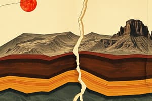
- Plate Tectonics: Lithosphere plates move due to mantle convection currents. Three types of plate boundaries: divergent, convergent, and transform.
- Divergent Boundaries: Plates move apart, creating new crust. Example: Mid-Atlantic Ridge.
- Convergent Boundaries: Plates collide, subduction occurs (denser plate sinks). Three subtypes: Continental-Continental Collision, Oceanic-Continental Collision, Oceanic-Oceanic Collision.
- Transform Boundaries: Plates slide past each other. Example: San Andreas Fault.
- Hotspots: Areas where magma rises from deep within the Earth's mantle creating volcanoes. These volcanoes aren't on plate boundaries.
- Soil: Composition of minerals, organic matter, gases, liquids, and organisms. Support plant life, store water. Soil profile features layers such as the O, A, B, and C horizons (and others).
- Leaching: Nutrients in soil are washed out due to excess water.
- Calcification: A process where minerals (like calcium) are left behind after water evaporates in arid regions, leaving a higher amount near the surface.
- Climate Regions: Arctic, Taiga, Cordilleran, Pacific Maritime, Boreal, Prairie, Southeastern, Atlantic Maritime.
- Precipitation Types: Relief and convectional precipitations
- Climate factors: latitude, elevation, relief, near water
- Population Density: Number of people per square kilometer.
- Population Distribution: General pattern of population distribution across a region (e.g linear, concentrated, dispersed).
- Population Growth Rate: Natural increase rate + net migration rate
- Dependency Load: Proportion of population that must be supported that are not working-age.
- Push and Pull Factors: Factors influencing migration
- Types of Urban Land Use: Residential, transportation, commercial, industrial, institutional, open space.
- Natural Vegetation Regions: Deciduous, mixed wood, boreal forest, grasslands, etc.
- Types of Renewable Energy: Hydropower, solar, geothermal, biomass, wind.
- Non-Renewable Energy: Coal, oil and natural gas, nuclear
- Sustainable Resource Management: Practices and approaches to managing resources responsibly to ensure their availability in the future.
Studying That Suits You
Use AI to generate personalized quizzes and flashcards to suit your learning preferences.