Podcast
Questions and Answers
Which rock is older, the limestone (A) or the igneous sill (B)?
Which rock is older, the limestone (A) or the igneous sill (B)?
- Limestone (correct)
- Igneous sill
What type of unconformity is found at the location indicated by the arrow?
What type of unconformity is found at the location indicated by the arrow?
- Disconformity
- Angular unconformity (correct)
- Paraconformity
- Nonconformity
What type of unconformity is found at the location indicated by the arrow?
What type of unconformity is found at the location indicated by the arrow?
- Angular unconformity
- Nonconformity (correct)
- Paraconformity
- Disconformity
What is an index fossil?
What is an index fossil?
Which rocks are older, the lower gray muddy sandstone or the upper reddish sandstone?
Which rocks are older, the lower gray muddy sandstone or the upper reddish sandstone?
What is stress (in geology)?
What is stress (in geology)?
What is the geological structure shown in this image called?
What is the geological structure shown in this image called?
The hanging wall is on the __________ side of this fault.
The hanging wall is on the __________ side of this fault.
The hanging wall block moves up relative to the footwall block in reverse dip-slip faults.
The hanging wall block moves up relative to the footwall block in reverse dip-slip faults.
Match the images below with the type of fault.
Match the images below with the type of fault.
What type of stress would cause the fault pictured below?
What type of stress would cause the fault pictured below?
What type of stress would cause the fault pictured below?
What type of stress would cause the fault pictured below?
Which type of fault is best matched with the appropriate plate boundary?
Which type of fault is best matched with the appropriate plate boundary?
What is the term used to refer to a horizontal line on an inclined fault surface (or any surface)?
What is the term used to refer to a horizontal line on an inclined fault surface (or any surface)?
What is the term used to refer to the inclination of an inclined fault surface (or any surface)?
What is the term used to refer to the inclination of an inclined fault surface (or any surface)?
What type of structure is the man standing in front of in this image?
What type of structure is the man standing in front of in this image?
What type of structure is shown in this image?
What type of structure is shown in this image?
What type of structure can be observed in this image?
What type of structure can be observed in this image?
What kind of structure can be observed in this satellite image?
What kind of structure can be observed in this satellite image?
What type of stress would you expect to occur along a transform boundary?
What type of stress would you expect to occur along a transform boundary?
What type of fault would occur as a result of compressive stress?
What type of fault would occur as a result of compressive stress?
You are exploring an area and find many reverse faults, synclines, and anticlines. Which of these tectonic settings would you hypothesize caused the deformation you see?
You are exploring an area and find many reverse faults, synclines, and anticlines. Which of these tectonic settings would you hypothesize caused the deformation you see?
Ocean basins exist because ________________ (select all that apply).
Ocean basins exist because ________________ (select all that apply).
Which of the following changes to the crust would act to increase regional elevations? (Choose all that apply.)
Which of the following changes to the crust would act to increase regional elevations? (Choose all that apply.)
If a region has extensive normal faulting, would you expect that region to have high regional elevation, high relief, or both?
If a region has extensive normal faulting, would you expect that region to have high regional elevation, high relief, or both?
If a region has extensive reverse faulting and folding, would you expect that region to have high regional elevation, high relief, or both?
If a region has extensive reverse faulting and folding, would you expect that region to have high regional elevation, high relief, or both?
Currently, the most widely accepted hypothesis for the formation of the Rocky Mountains involves _________________.
Currently, the most widely accepted hypothesis for the formation of the Rocky Mountains involves _________________.
Match the relative dating principle with its definition.
Match the relative dating principle with its definition.
Using the image shown below, how would you know which rock is older A or G? i.e., which of these relative dating principles would be most useful?
Using the image shown below, how would you know which rock is older A or G? i.e., which of these relative dating principles would be most useful?
Match the type of unconformity with the correct description.
Match the type of unconformity with the correct description.
Isotopes are atoms of the same element but have different numbers of __________.
Isotopes are atoms of the same element but have different numbers of __________.
Which of the following statements about the half-life of a radioactive isotope is true?
Which of the following statements about the half-life of a radioactive isotope is true?
If a rock starts off with 100 radioactive parent atoms, how many parent atoms will be left after 2 half-lives?
If a rock starts off with 100 radioactive parent atoms, how many parent atoms will be left after 2 half-lives?
Which of these is the comparison and correlation of strata within a region by examining the physical properties of the rock and its sequence with other strata?
Which of these is the comparison and correlation of strata within a region by examining the physical properties of the rock and its sequence with other strata?
Organisms that lived for relatively short time periods are particularly useful for dating rocks, especially if they were distributed over a wide geographic area and so can be used to compare rocks from different regions. These organisms are known as ____________.
Organisms that lived for relatively short time periods are particularly useful for dating rocks, especially if they were distributed over a wide geographic area and so can be used to compare rocks from different regions. These organisms are known as ____________.
Which represents the longest interval of geological time?
Which represents the longest interval of geological time?
What is the currently scientifically accepted age of the Earth?
What is the currently scientifically accepted age of the Earth?
The block diagram above shows the various rock units that can be found in the Grand Canyon. Using the Principles of Relative Dating, put the rock units in order from oldest (1) to youngest (19).
The block diagram above shows the various rock units that can be found in the Grand Canyon. Using the Principles of Relative Dating, put the rock units in order from oldest (1) to youngest (19).
You have measured the concentration of Uranium-235 and Lead-207 in the Vishnu Schist (Unit F on the Grand Canyon block diagram). U-235 is radioactive and decays into Pb-207. You have found 18 ppb (parts per billion) of U-235 and 72 ppb of Pb-207. Approximately how many half-lives of U-235 have passed since the Vishnu Schist formed?
You have measured the concentration of Uranium-235 and Lead-207 in the Vishnu Schist (Unit F on the Grand Canyon block diagram). U-235 is radioactive and decays into Pb-207. You have found 18 ppb (parts per billion) of U-235 and 72 ppb of Pb-207. Approximately how many half-lives of U-235 have passed since the Vishnu Schist formed?
You have measured the concentration of Uranium-235 and Lead-207 in the Vishnu Schist (Unit F on the Grand Canyon block diagram). You have found 18 ppb (parts per billion) of U-235 and 72 ppb of Pb-207. Using the chart and table above determine the numerical age of the Vishnu Schist.
You have measured the concentration of Uranium-235 and Lead-207 in the Vishnu Schist (Unit F on the Grand Canyon block diagram). You have found 18 ppb (parts per billion) of U-235 and 72 ppb of Pb-207. Using the chart and table above determine the numerical age of the Vishnu Schist.
You have measured the concentration of Potassium-40 and Argon-40 in the Cardenas Basalt (Unit A). You have found 65 ppb (parts per billion) of K-40 and 35 ppb of Ar-40. Using the chart and table above, determine the approximate numerical age of the Cardenas Basalt.
You have measured the concentration of Potassium-40 and Argon-40 in the Cardenas Basalt (Unit A). You have found 65 ppb (parts per billion) of K-40 and 35 ppb of Ar-40. Using the chart and table above, determine the approximate numerical age of the Cardenas Basalt.
During which of these time intervals did the supercontinent Pangea form?
During which of these time intervals did the supercontinent Pangea form?
During which of these time intervals do the oldest fossils come from?
During which of these time intervals do the oldest fossils come from?
During which of these time intervals did flowering plants appear?
During which of these time intervals did flowering plants appear?
The most severe mass extinction in Earth's history occurred at the end of which of these time periods?
The most severe mass extinction in Earth's history occurred at the end of which of these time periods?
At the end of which of these time intervals did the non-avian dinosaurs go extinct?
At the end of which of these time intervals did the non-avian dinosaurs go extinct?
During which of these time intervals did modern humans appear?
During which of these time intervals did modern humans appear?
An earthquake occurs when ___________________.
An earthquake occurs when ___________________.
Where do most earthquakes occur?
Where do most earthquakes occur?
Which of these terms is defined as the point on the land surface directly above the location where the earthquake occurred?
Which of these terms is defined as the point on the land surface directly above the location where the earthquake occurred?
Which of these terms is defined as the point within the Earth where the earthquake occurred?
Which of these terms is defined as the point within the Earth where the earthquake occurred?
Which of these seismic waves travel through compression (like the compression of the coils of a spring, similar to the way sound travels)?
Which of these seismic waves travel through compression (like the compression of the coils of a spring, similar to the way sound travels)?
Which of these seismic waves only travel along Earth's surface? (Select all that apply)
Which of these seismic waves only travel along Earth's surface? (Select all that apply)
Indicate the order in which these seismic waves would arrive at a seismic station following an earthquake.
Indicate the order in which these seismic waves would arrive at a seismic station following an earthquake.
Which scale would you use if you wanted to measure the amount of shaking felt by people and damage that occurred as a result of an earthquake?
Which scale would you use if you wanted to measure the amount of shaking felt by people and damage that occurred as a result of an earthquake?
Which of these measurements will vary for a given earthquake depending on how far away from the epicenter you are?
Which of these measurements will vary for a given earthquake depending on how far away from the epicenter you are?
Which of the following conditions would increase the Moment Magnitude of an earthquake? (Select all that apply.)
Which of the following conditions would increase the Moment Magnitude of an earthquake? (Select all that apply.)
How would the seismogram below change if the seismic station was farther from the earthquake epicenter? (Choose all that apply.)
How would the seismogram below change if the seismic station was farther from the earthquake epicenter? (Choose all that apply.)
If a seismic station recorded the arrival of S waves from an earthquake 3 minutes after the arrival of P waves, how far is that station from the epicenter of the earthquake?
If a seismic station recorded the arrival of S waves from an earthquake 3 minutes after the arrival of P waves, how far is that station from the epicenter of the earthquake?
The 2010 Haiti earthquake had a rupture area estimated to be 30 km long and 11 km wide, and a displacement on the fault of 4 m. Use the Moment Magnitude calculator linked here to estimate the Moment Magnitude of the Haiti earthquake.
The 2010 Haiti earthquake had a rupture area estimated to be 30 km long and 11 km wide, and a displacement on the fault of 4 m. Use the Moment Magnitude calculator linked here to estimate the Moment Magnitude of the Haiti earthquake.
The March 11, 2011 earthquake off the coast of Japan had a Moment Magnitude of 9.1. The dimensions of the rupture area during the earthquake are estimated to have been 300 km long and 150 km wide. Use the Moment Magnitude calculator linked here to estimate the amount of displacement on the fault that must have occurred.
The March 11, 2011 earthquake off the coast of Japan had a Moment Magnitude of 9.1. The dimensions of the rupture area during the earthquake are estimated to have been 300 km long and 150 km wide. Use the Moment Magnitude calculator linked here to estimate the amount of displacement on the fault that must have occurred.
Which of the areas indicated on the map have a 2% Probability of exceeding shaking equivalent to 80% of gravity in the next 50 years? (Choose all that apply.)
Which of the areas indicated on the map have a 2% Probability of exceeding shaking equivalent to 80% of gravity in the next 50 years? (Choose all that apply.)
The figure below shows varying seismic hazard within the Seattle region. What is the most likely cause for the variability in shaking intensity expected in different areas?
The figure below shows varying seismic hazard within the Seattle region. What is the most likely cause for the variability in shaking intensity expected in different areas?
Investigate the recent earthquake near Palu, Indonesia. What is the tectonic setting that caused this earthquake?
Investigate the recent earthquake near Palu, Indonesia. What is the tectonic setting that caused this earthquake?
Investigate the recent earthquake near Palu, Indonesia. What is the highest Intensity of shaking that was predicted for this earthquake by the Shakemap model?
Investigate the recent earthquake near Palu, Indonesia. What is the highest Intensity of shaking that was predicted for this earthquake by the Shakemap model?
Investigate the recent earthquake near Palu, Indonesia. What is the highest Intensity of shaking that was reported for this earthquake by people using the Did You Feel It feature?
Investigate the recent earthquake near Palu, Indonesia. What is the highest Intensity of shaking that was reported for this earthquake by people using the Did You Feel It feature?
Investigate the recent earthquake near Palu, Indonesia. How many people were estimated to have experienced violent shaking (Intensity IX) according to the PAGER model?
Investigate the recent earthquake near Palu, Indonesia. How many people were estimated to have experienced violent shaking (Intensity IX) according to the PAGER model?
Investigate the recent earthquake near Palu, Indonesia. How many shaking-related fatalities were most likely to have occurred as a result of this earthquake according to the PAGER model?
Investigate the recent earthquake near Palu, Indonesia. How many shaking-related fatalities were most likely to have occurred as a result of this earthquake according to the PAGER model?
In a reverse fault, the hanging wall moves UP relative to the footwall.
In a reverse fault, the hanging wall moves UP relative to the footwall.
What type of fault is shown here? Sangre de Cristo Fault San Luis Valley
What type of fault is shown here? Sangre de Cristo Fault San Luis Valley
Stream offset by the San Andreas Fault! What type of fault is this?
Stream offset by the San Andreas Fault! What type of fault is this?
A Normal Fault is a result of what kind of stress?
A Normal Fault is a result of what kind of stress?
What type of structure is shown in this image? Rabbit Valley, western Colorado
What type of structure is shown in this image? Rabbit Valley, western Colorado
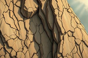
What type of structure is shown in this image? Mosaic Canyon
What type of structure is shown in this image? Mosaic Canyon
What type of structure is shown in this image? Mojave Preserve
What type of structure is shown in this image? Mojave Preserve
What type of structure is shown in this image? Mexican Hat
What type of structure is shown in this image? Mexican Hat
What type of structure is shown in this image? Sheep Mountain
What type of structure is shown in this image? Sheep Mountain
In general, which type of faults would you predict to find at a convergent plate boundary?
In general, which type of faults would you predict to find at a convergent plate boundary?
In general, which type of faults would you predict to find at a divergent plate boundary?
In general, which type of faults would you predict to find at a divergent plate boundary?
At which type of plate boundary setting would you predict most folding to occur?
At which type of plate boundary setting would you predict most folding to occur?
Let's make some predictions: We will define elevation as the height above the liquid surface (difference between block height and block root). If we increase the block thickness, __________.
Let's make some predictions: We will define elevation as the height above the liquid surface (difference between block height and block root). If we increase the block thickness, __________.
If we increase the density of the block, __________.
If we increase the density of the block, __________.
If we increase the density of the liquid, __________.
If we increase the density of the liquid, __________.
Why do we have ocean basins?
Why do we have ocean basins?
Predict: which of the following processes would increase regional elevation?
Predict: which of the following processes would increase regional elevation?
Ways to Increase Regional Elevation
Ways to Increase Regional Elevation
Ways to Decrease Regional Elevation
Ways to Decrease Regional Elevation
How Faulting Can Form Mountains (Relief)
How Faulting Can Form Mountains (Relief)
How could the Rocky Mountains have formed?
How could the Rocky Mountains have formed?
How are rock types related to elevation in Colorado?
How are rock types related to elevation in Colorado?
What must have happened at some time after the igneous and metamorphic rocks formed?
What must have happened at some time after the igneous and metamorphic rocks formed?
According to isostasy, thicker crust gives us _____ elevation.
According to isostasy, thicker crust gives us _____ elevation.
According to isostasy, denser crust gives us _____ elevation.
According to isostasy, denser crust gives us _____ elevation.
Reverse or thrust faulting tends to increase ___________.
Reverse or thrust faulting tends to increase ___________.
Which of these best describes the order of events that must have happened to explain the sedimentary rocks we see at Red Rocks Amphitheater?
Which of these best describes the order of events that must have happened to explain the sedimentary rocks we see at Red Rocks Amphitheater?
Which Rock is older, the felsic igneous rock (A) or the mafic igneous rock (B)?
Which Rock is older, the felsic igneous rock (A) or the mafic igneous rock (B)?
Normal faulting tends to increase __________.
Normal faulting tends to increase __________.
If you crush a soda can, what type of stress are you applying?
If you crush a soda can, what type of stress are you applying?
Flashcards are hidden until you start studying
Study Notes
Geology: Key Concepts and Terms
- Stress in geology refers to the force applied to a specific area of rock.
- Geological structures like synclines and anticlines represent the folding of rock layers under pressure.
- In a fault, the hanging wall is on the right side during a right-lateral strike-slip fault.
- In reverse dip-slip faults, the hanging wall block moves upward relative to the footwall.
- Normal faults are results of tension stress, while reverse faults arise from compressive stress.
- Strike-slip faults exhibit horizontal movement along the fault line and are categorized as right-lateral or left-lateral based on the movement direction.
- Strike and dip are crucial terms for fault surfaces, where strike refers to a horizontal line on the inclined fault surface and dip denotes the angle of inclination.
Fault Types and Geological Structures
- A reverse fault is identified by the upward movement of the hanging wall compared to the footwall.
- Normal faults occur as a result of extensional forces, leading to the dropping of the hanging wall.
- Structures like monoclines and anticlines are important in understanding tectonic forces and geological formations.
- The hanging wall moves up in a reverse fault while it moves down in a normal fault.
Stress and Plate Boundaries
- Tension stress is associated with normal faults, while shear stress is linked to strike-slip faults along transform boundaries.
- The type of fault corresponds with the type of tectonic plate boundary: normal faults are found at divergent boundaries, whereas reverse faults are found at convergent boundaries.
Geological Time and Dating
- Isotopes have varying neutron counts, impacting their stability and decay rates, which is crucial for dating rocks through techniques like radiometric dating.
- The half-life of isotopes indicates the time it takes for half of the radioactive parent isotopes to decay into daughter isotopes.
- Principles like superposition and cross-cutting relationships aid in determining the relative ages of rock layers.
Eons and Geological Events
- The currently accepted age of the Earth is approximately 4.54 billion years.
- Important geological events include the formation of Pangea during the Permian and significant mass extinctions at the end of this period.
- Index fossils play a pivotal role in dating and correlating rock layers due to their widespread distribution and short geological lifespan.
Seismology and Earthquake Mechanisms
- Earthquakes occur when there's a rupture along a fault, usually at plate boundaries.
- Hypocenter is the point within the Earth where the earthquake originates, while the epicenter is the surface point above it.
- P-waves (primary waves) travel through compression, while S-waves and surface waves (Love and Rayleigh waves) carry energy along the Earth's surface.
- The Moment Magnitude scale measures the energy released during an earthquake, considering the area of the fault that slipped.
Earthquake Effects and Measurements
- Factors like the rigidity of rocks and the amount of fault displacement directly affect the Moment Magnitude.
- The intensity of an earthquake measures the shaking felt at various distances from the epicenter and can vary with distance.
- Tools like ShakeMap predict shaking intensity and help estimate the impact on populations and structures.
Geological Features and Elevation
- The elevation and relief of landforms are influenced by crust thickness and density, with thicker and less dense crust generally leading to higher elevations.
- Processes like faulting and crustal thickening can lead to the formation of mountains.
- The presence of dense oceanic crust leads to lower elevation compared to continental crust.
Insights into Geological Conservation
- Methods to increase regional elevation include adding surface material, heating the crust, or shortening/thickening the crust.
- Crustal cooling, eroding material, and structurally thinning crust contribute to decreased regional elevation.
Summary of Geological Principles
- Relative dating principles guide the interpretation of geological history, with sedimentary rock layers displaying an ordered accumulation over time.
- Understanding geological processes helps recognize the transformation of landscapes and predicts the occurrence of natural events like earthquakes.
Studying That Suits You
Use AI to generate personalized quizzes and flashcards to suit your learning preferences.