Podcast
Questions and Answers
What is the definition of relief in geography?
What is the definition of relief in geography?
Relief refers to the variations in elevation, shape, and slope of the Earth's surface, defining the topography of a region.
What geological processes primarily influence relief?
What geological processes primarily influence relief?
Tectonic activity, erosion, deposition, and weathering.
Which of the following are NOT considered major types of relief?
Which of the following are NOT considered major types of relief?
- Hills
- Mountains
- Valleys
- Plateaus
- Forests (correct)
- Plains
Mountains are formed solely by volcanic activity.
Mountains are formed solely by volcanic activity.
What is a significant feature of plains?
What is a significant feature of plains?
Which of these landforms is known for its steep cliffs and level or gently sloping surface?
Which of these landforms is known for its steep cliffs and level or gently sloping surface?
What is the primary characteristic of valleys?
What is the primary characteristic of valleys?
Which of the following is NOT a characteristic of deserts?
Which of the following is NOT a characteristic of deserts?
What is the primary factor that influences climate?
What is the primary factor that influences climate?
Tropical climates are characterized by cold temperatures year-round.
Tropical climates are characterized by cold temperatures year-round.
Which of these subtypes of climate is characterized by distinct seasons with mild, wet winters and hot, dry summers?
Which of these subtypes of climate is characterized by distinct seasons with mild, wet winters and hot, dry summers?
What is the defining characteristic of Polar climates?
What is the defining characteristic of Polar climates?
Highland climates are always warm, regardless of altitude.
Highland climates are always warm, regardless of altitude.
What are the major types of relief?
What are the major types of relief?
Mountains are formed by tectonic plate movements such as folding, faulting, and volcanic activity.
Mountains are formed by tectonic plate movements such as folding, faulting, and volcanic activity.
What are the main factors that influence climate?
What are the main factors that influence climate?
Which climate type is characterized by warm temperatures year-round with high humidity and includes wet and dry seasons?
Which climate type is characterized by warm temperatures year-round with high humidity and includes wet and dry seasons?
The ______ climate is characterized by low precipitation, extreme temperatures with hot days and cold nights, and is found in regions like the Sahara Desert and the Gobi Desert.
The ______ climate is characterized by low precipitation, extreme temperatures with hot days and cold nights, and is found in regions like the Sahara Desert and the Gobi Desert.
Flashcards
Relief
Relief
Variations in elevation, shape, and slope of the Earth's surface, shaping the landscape.
Mountains
Mountains
High elevation landforms with steep slopes, rugged terrain, and often snow-capped peaks.
How are Mountains Formed?
How are Mountains Formed?
Created by tectonic plate movements, including folding, faulting, and volcanic activity.
Significance of Mountains
Significance of Mountains
Signup and view all the flashcards
Hills
Hills
Signup and view all the flashcards
How are Hills Formed?
How are Hills Formed?
Signup and view all the flashcards
Significance of Hills
Significance of Hills
Signup and view all the flashcards
Plains
Plains
Signup and view all the flashcards
How are Plains Formed?
How are Plains Formed?
Signup and view all the flashcards
Significance of Plains
Significance of Plains
Signup and view all the flashcards
Plateaus
Plateaus
Signup and view all the flashcards
How are Plateaus Formed?
How are Plateaus Formed?
Signup and view all the flashcards
Significance of Plateaus
Significance of Plateaus
Signup and view all the flashcards
Valleys
Valleys
Signup and view all the flashcards
How are Valleys Formed?
How are Valleys Formed?
Signup and view all the flashcards
Significance of Valleys
Significance of Valleys
Signup and view all the flashcards
Deserts (Relief Aspect)
Deserts (Relief Aspect)
Signup and view all the flashcards
How are Deserts Formed?
How are Deserts Formed?
Signup and view all the flashcards
Climate
Climate
Signup and view all the flashcards
What factors influence climate?
What factors influence climate?
Signup and view all the flashcards
Tropical Climate
Tropical Climate
Signup and view all the flashcards
Dry (Arid and Semi-Arid)
Dry (Arid and Semi-Arid)
Signup and view all the flashcards
Temperate Climate
Temperate Climate
Signup and view all the flashcards
Continental Climate
Continental Climate
Signup and view all the flashcards
Polar Climate
Polar Climate
Signup and view all the flashcards
Highland Climate
Highland Climate
Signup and view all the flashcards
Rainforest
Rainforest
Signup and view all the flashcards
Savanna
Savanna
Signup and view all the flashcards
Mediterranean
Mediterranean
Signup and view all the flashcards
Oceanic
Oceanic
Signup and view all the flashcards
Humid Continental
Humid Continental
Signup and view all the flashcards
Subarctic
Subarctic
Signup and view all the flashcards
Tundra
Tundra
Signup and view all the flashcards
Ice Cap
Ice Cap
Signup and view all the flashcards
What shapes Earth's surface?
What shapes Earth's surface?
Signup and view all the flashcards
What creates relief?
What creates relief?
Signup and view all the flashcards
Mountains: Elevation?
Mountains: Elevation?
Signup and view all the flashcards
What forms Mountains?
What forms Mountains?
Signup and view all the flashcards
Why are Mountains Important?
Why are Mountains Important?
Signup and view all the flashcards
Hills: Height vs. Mountains?
Hills: Height vs. Mountains?
Signup and view all the flashcards
What forms Hills?
What forms Hills?
Signup and view all the flashcards
Why are Hills Useful?
Why are Hills Useful?
Signup and view all the flashcards
Plains: What is it?
Plains: What is it?
Signup and view all the flashcards
How do Plains Form?
How do Plains Form?
Signup and view all the flashcards
Why are Plains Important?
Why are Plains Important?
Signup and view all the flashcards
Plateaus: High and Flat?
Plateaus: High and Flat?
Signup and view all the flashcards
What makes Plateaus?
What makes Plateaus?
Signup and view all the flashcards
Plateaus: Good for what?
Plateaus: Good for what?
Signup and view all the flashcards
Valleys: Low and Long?
Valleys: Low and Long?
Signup and view all the flashcards
How are Valleys Created?
How are Valleys Created?
Signup and view all the flashcards
Why are Valleys Ideal?
Why are Valleys Ideal?
Signup and view all the flashcards
What's a Desert's Relief?
What's a Desert's Relief?
Signup and view all the flashcards
How do Deserts Form?
How do Deserts Form?
Signup and view all the flashcards
What's a Desert's Climate?
What's a Desert's Climate?
Signup and view all the flashcards
What is Climate?
What is Climate?
Signup and view all the flashcards
What Factors Impact Climate?
What Factors Impact Climate?
Signup and view all the flashcards
Tropical Climate: Warm and Wet?
Tropical Climate: Warm and Wet?
Signup and view all the flashcards
Dry Climate: Dry and Extreme?
Dry Climate: Dry and Extreme?
Signup and view all the flashcards
Temperate Climate: Moderate and Seasonal?
Temperate Climate: Moderate and Seasonal?
Signup and view all the flashcards
Continental Climate: Extreme Temperature Changes?
Continental Climate: Extreme Temperature Changes?
Signup and view all the flashcards
Polar Climate: Cold and Icy?
Polar Climate: Cold and Icy?
Signup and view all the flashcards
Highland Climate: Altitude Impact?
Highland Climate: Altitude Impact?
Signup and view all the flashcards
What's a Rainforest?
What's a Rainforest?
Signup and view all the flashcards
What's a Savanna?
What's a Savanna?
Signup and view all the flashcards
What's a Mediterranean Climate?
What's a Mediterranean Climate?
Signup and view all the flashcards
What's an Oceanic Climate?
What's an Oceanic Climate?
Signup and view all the flashcards
What's a Humid Continental Climate?
What's a Humid Continental Climate?
Signup and view all the flashcards
What's a Subarctic Climate?
What's a Subarctic Climate?
Signup and view all the flashcards
What's a Tundra?
What's a Tundra?
Signup and view all the flashcards
What is an Ice Cap?
What is an Ice Cap?
Signup and view all the flashcards
Study Notes
Types of Relief
- Relief describes variations in elevation, shape, and slope of the Earth's surface.
- It's determined by tectonic activity, erosion, deposition, and weathering.
- Major relief types include mountains, hills, plains, plateaus, valleys, deserts, and highlands.
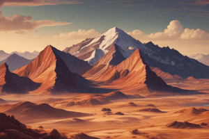
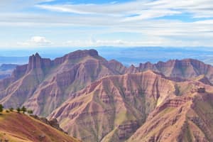
Mountains
- Characteristics: High elevation, steep slopes, rugged terrain, often snow-capped.
- Formation: Created by tectonic plate movements (folding, faulting, volcanic activity).
- Significance: Sources of rivers, rich in minerals, act as climatic barriers (e.g., rain shadows).
- Examples: Himalayas, Andes, Rockies.
Hills
- Characteristics: Elevated landforms lower than mountains, rounded tops, moderate slopes.
- Formation: Erosion of mountains or sediment deposition.
- Significance: Suitable for agriculture, settlements, grazing.
- Examples: Chocolate Hills, Shropshire Hills.
Plains
- Characteristics: Large expanses of flat or gently rolling terrain with minimal elevation.
- Formation: Often created by sediment deposition from rivers, glacial activity, or ancient seabeds.
- Significance: Fertile soils, ideal for agriculture, dense human habitation.
- Examples: Great Plains, Indo-Gangetic Plains.
Plateaus
- Characteristics: Elevated flatlands, often bounded by steep cliffs, with a level or gently sloping surface.
- Formation: Uplift of land due to tectonic activity or volcanic eruptions.
- Significance: Rich in minerals and natural resources, suitable for grazing and forestry.
- Examples: Deccan Plateau, Colorado Plateau.
Valleys
- Characteristics: Low-lying areas between hills or mountains, often with a river running through.
- Formation: Created by river erosion, glacial activity, or tectonic forces.
- Significance: Fertile soils, access to water, ideal for agriculture and settlements.
- Examples: Rhine Valley, Great Rift Valley.
Deserts (Relief Aspect)
- Characteristics: Arid, barren regions with unique landforms like dunes, mesas, and rocky plateaus.
- Formation: Shaped by wind erosion and lack of water.
- Significance: Sparse vegetation, often rich in minerals.
- Examples: Sahara Desert, Atacama Desert.
Types of Climates
- Climate describes average weather conditions over a long period (typically 30 years).
- Influenced by latitude, altitude, proximity to water bodies, and ocean currents.
- Major climate types include tropical, dry, temperate, continental, polar, and highland.
Tropical
- Characteristics: Warm temperatures, high humidity, often wet and dry seasons.
- Examples: Amazon Rainforest, Congo Basin.
- Subtypes: Rainforest (high rainfall, dense vegetation), Savanna (seasonal rainfall, grassy plains).
Dry (Arid and Semi-Arid)
- Characteristics: Low precipitation, extreme temperatures (hot days, cold nights).
- Examples: Sahara Desert, Gobi Desert.
- Subtypes: Arid (very dry), Semi-Arid (slightly more rainfall, grasslands).
Temperate
- Characteristics: Moderate temperatures, distinct seasons.
- Examples: Western Europe, Eastern USA.
- Subtypes: Mediterranean (mild wet winters, hot dry summers), Oceanic (moderate temperatures, consistent rainfall).
Continental
- Characteristics: Large temperature variations between summer and winter.
- Examples: Siberia, Midwestern USA.
- Subtypes: Humid Continental (more precipitation), Subarctic (harsh winters, short summers).
Polar
- Characteristics: Extremely cold temperatures, ice-covered landscapes, minimal vegetation.
- Examples: Antarctica, Arctic Circle.
- Subtypes: Tundra (slightly milder summers, mosses/lichens), Ice Cap (perpetual ice and snow).
Highland
- Characteristics: Climate varies with altitude, higher elevations are colder and receive more precipitation.
- Examples: Andes, Himalayas.
- Subtypes: Dependent on latitude and altitude.
Studying That Suits You
Use AI to generate personalized quizzes and flashcards to suit your learning preferences.