Podcast
Questions and Answers
What is the primary cause of sediment deposition on a floodplain?
What is the primary cause of sediment deposition on a floodplain?
- Increased river velocity
- Decreased river efficiency (correct)
- Erosion of riverbanks
- Higher water levels
Which of the following is a consequence of river flooding?
Which of the following is a consequence of river flooding?
- Formation of hydraulic features
- Enhancement of water quality
- Destruction of properties (correct)
- Increased agricultural productivity
What makes floodplains particularly suitable for agriculture?
What makes floodplains particularly suitable for agriculture?
- Frequent flooding
- Low water table
- Availability of alluvial soil (correct)
- Consistent erosion
Which of the following is NOT considered a river hazard?
Which of the following is NOT considered a river hazard?
River erosion primarily affects which of the following?
River erosion primarily affects which of the following?
Which of the following is a benefit of rivers for urban areas?
Which of the following is a benefit of rivers for urban areas?
Which of these is a direct negative impact of river flooding on human activities?
Which of these is a direct negative impact of river flooding on human activities?
What role do rivers play in terms of tourism?
What role do rivers play in terms of tourism?
What causes the formation of a gorge in a river?
What causes the formation of a gorge in a river?
How are potholes formed in the upper course of a river?
How are potholes formed in the upper course of a river?
What characterizes rapids in a river?
What characterizes rapids in a river?
What happens to the overhang of harder rock during the erosion process at a waterfall?
What happens to the overhang of harder rock during the erosion process at a waterfall?
What primarily contributes to the formation of natural embankments alongside a river?
What primarily contributes to the formation of natural embankments alongside a river?
What is the impact of resistant rocks on rapids?
What is the impact of resistant rocks on rapids?
How does sediment deposition change as the distance from the river course increases during a flood?
How does sediment deposition change as the distance from the river course increases during a flood?
What is a primary feature of a gorge formed by a waterfall retreating upstream?
What is a primary feature of a gorge formed by a waterfall retreating upstream?
Which of the following shapes does NOT typically describe a delta?
Which of the following shapes does NOT typically describe a delta?
In which part of a river is the formation of potholes most likely to occur?
In which part of a river is the formation of potholes most likely to occur?
What triggers the loss of energy in a river leading to sediment deposition at a delta?
What triggers the loss of energy in a river leading to sediment deposition at a delta?
What role does hydraulic action play in the erosion process at waterfalls?
What role does hydraulic action play in the erosion process at waterfalls?
Which delta shape is most commonly formed when river currents are stronger than ocean waves?
Which delta shape is most commonly formed when river currents are stronger than ocean waves?
What defines an estuary?
What defines an estuary?
What are floodplains primarily characterized by?
What are floodplains primarily characterized by?
What role does a distributary play in a delta?
What role does a distributary play in a delta?
What primarily causes the formation of meanders in a river?
What primarily causes the formation of meanders in a river?
Which process contributes to the eventual isolation of an ox-bow lake from the river?
Which process contributes to the eventual isolation of an ox-bow lake from the river?
What is primarily formed by the processes of erosion on the outer bank and deposition on the inner bank of a river?
What is primarily formed by the processes of erosion on the outer bank and deposition on the inner bank of a river?
Which feature is characterized by a naturally formed bank alongside a river channel?
Which feature is characterized by a naturally formed bank alongside a river channel?
What typically occurs to an ox-bow lake over time?
What typically occurs to an ox-bow lake over time?
Which of the following statements best describes the role of pebble composition in river erosion?
Which of the following statements best describes the role of pebble composition in river erosion?
Which landform is typically associated with the deposition of sediments at the mouth of a river?
Which landform is typically associated with the deposition of sediments at the mouth of a river?
What leads to the creation of a slip-off slope within a meander?
What leads to the creation of a slip-off slope within a meander?
Which action is NOT part of flood control and management?
Which action is NOT part of flood control and management?
What is a primary negative effect of river flooding on people?
What is a primary negative effect of river flooding on people?
Which of the following is an example of hard-engineering in flood management?
Which of the following is an example of hard-engineering in flood management?
How does climate change contribute to flooding?
How does climate change contribute to flooding?
What is a positive value of river flooding?
What is a positive value of river flooding?
What effect does flooding have on the environment?
What effect does flooding have on the environment?
Which structure is primarily used to control the discharge of a river?
Which structure is primarily used to control the discharge of a river?
What is a significant consequence of destroyed waste pipes during flooding?
What is a significant consequence of destroyed waste pipes during flooding?
What impact does the shape of a drainage basin have on flood risk?
What impact does the shape of a drainage basin have on flood risk?
How does soil permeability affect flooding in a drainage basin?
How does soil permeability affect flooding in a drainage basin?
What is the role of vegetation in mitigating flood risk in drainage basins?
What is the role of vegetation in mitigating flood risk in drainage basins?
How does the relief of a basin contribute to flood risks?
How does the relief of a basin contribute to flood risks?
What effect do tributaries have on a river's flood risk?
What effect do tributaries have on a river's flood risk?
How does urbanization contribute to increased flooding?
How does urbanization contribute to increased flooding?
What is a consequence of deforestation on flood risk?
What is a consequence of deforestation on flood risk?
What role do dams play in a river system concerning flood risk?
What role do dams play in a river system concerning flood risk?
Flashcards
Overhang Formation
Overhang Formation
Harder rock remains above softer eroded rock, forming an overhang.
Plunge Pool Formation
Plunge Pool Formation
Falling water erodes riverbed to create a deep basin.
Gorge Formation
Gorge Formation
Overhang collapse leads to a steep-sided, narrow valley.
Gorge Characteristics
Gorge Characteristics
Signup and view all the flashcards
Rapids Formation
Rapids Formation
Signup and view all the flashcards
Rapids Characteristics
Rapids Characteristics
Signup and view all the flashcards
Pothole Formation
Pothole Formation
Signup and view all the flashcards
Pothole Location
Pothole Location
Signup and view all the flashcards
Floodplain Formation
Floodplain Formation
Signup and view all the flashcards
Levee Formation
Levee Formation
Signup and view all the flashcards
Delta Formation
Delta Formation
Signup and view all the flashcards
Delta Types
Delta Types
Signup and view all the flashcards
Arcuate Delta
Arcuate Delta
Signup and view all the flashcards
Cuspate Delta
Cuspate Delta
Signup and view all the flashcards
Bird's Foot Delta
Bird's Foot Delta
Signup and view all the flashcards
Distributary
Distributary
Signup and view all the flashcards
What forms a meander?
What forms a meander?
Signup and view all the flashcards
How are oxbow lakes formed?
How are oxbow lakes formed?
Signup and view all the flashcards
What are levees?
What are levees?
Signup and view all the flashcards
What is a flood plain?
What is a flood plain?
Signup and view all the flashcards
What are deltas?
What are deltas?
Signup and view all the flashcards
What are estuaries?
What are estuaries?
Signup and view all the flashcards
What are alluvial fans?
What are alluvial fans?
Signup and view all the flashcards
How do rivers erode their bed?
How do rivers erode their bed?
Signup and view all the flashcards
Floodplain Soil Fertility
Floodplain Soil Fertility
Signup and view all the flashcards
River Hazard: Floods
River Hazard: Floods
Signup and view all the flashcards
Flood Consequences
Flood Consequences
Signup and view all the flashcards
River Hazard: Erosion
River Hazard: Erosion
Signup and view all the flashcards
River Opportunity: Water Source
River Opportunity: Water Source
Signup and view all the flashcards
River Opportunity: Food Source
River Opportunity: Food Source
Signup and view all the flashcards
River Opportunity: Transportation
River Opportunity: Transportation
Signup and view all the flashcards
Flood Control
Flood Control
Signup and view all the flashcards
Dam Construction
Dam Construction
Signup and view all the flashcards
Embankments (Levees)
Embankments (Levees)
Signup and view all the flashcards
Climate Change Impacts on Floods
Climate Change Impacts on Floods
Signup and view all the flashcards
Negative Effects of Flooding
Negative Effects of Flooding
Signup and view all the flashcards
Flood Prediction
Flood Prediction
Signup and view all the flashcards
Flood Mitigation
Flood Mitigation
Signup and view all the flashcards
Flood Management
Flood Management
Signup and view all the flashcards
Circular Basin Flooding
Circular Basin Flooding
Signup and view all the flashcards
Impermeable Soil Flooding
Impermeable Soil Flooding
Signup and view all the flashcards
Vegetation and Flooding
Vegetation and Flooding
Signup and view all the flashcards
Steep Relief and Flooding
Steep Relief and Flooding
Signup and view all the flashcards
Tributaries and Flooding
Tributaries and Flooding
Signup and view all the flashcards
Urban Flooding
Urban Flooding
Signup and view all the flashcards
Deforestation and Flooding
Deforestation and Flooding
Signup and view all the flashcards
Dam and Flooding
Dam and Flooding
Signup and view all the flashcards
Study Notes
Rivers
- Rivers are formed by erosion and deposition
- Landforms can be categorized by the processes that formed them (erosion, deposition, or both) or their location (upper or lower course)
- Upland landforms are primarily created through erosion processes.
Upland Landforms
- Waterfalls
- Rapids
- Gorges
- V-shaped valleys
- Interlocking spurs
- Potholes
V-Shaped Valleys
- Form in mountainous regions
- Rivers have high energy, causing vertical erosion to deepen the river channel
- Weathering and mass movement contribute to the steep sides of the valley
- These materials are often added to the river forming a steep V shape
Interlocking Spurs
- Sharp, winding curves formed as rivers flow through alternating hard and soft rock
- Rivers erode soft rock faster than hard rock, creating a zigzag pattern along the valley sides
- Result of the river adapting to the varied rock formations
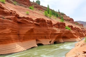
Waterfalls
- A drop in the river bed, often caused by hard rock overlying soft rock
- Hydraulic action and abrasion erode the soft rock, creating a plunge pool at the base
- Overhang of hard rock eventually collapses, causing the waterfall to retreat upstream.
Gorges
- Deep, narrow, and steep-sided valleys formed when a waterfall retreats upstream
- Resistant rock prevents significant widening from the river currents
- Formed when the hard rock of the waterfall is slowly eroded away, leaving a gorge behind
Rapids
- Steeper gradient in the river bed increasing water velocity and turbulence
- Rocks exposed above the river flow, creating whitewater
- Different rock resistances cause the variation in water flow
Potholes
- Cylindrical holes carved into the riverbed, often in the upper course
- Result of river turbulence and the rotational action of the load (often pebbles)
- Variable in depth and diameter, from a few centimetres to several meters
Lowland Landforms
- Meanders
- Oxbow lakes
- Levees
- Floodplains
- Deltas or estuaries
- Alluvial fans
- Formed through deposition of material carried by the river
Meanders
- Winding curves or bends in a river, typically found in the lower course
- Result of varying water speeds on the river bank; faster on the outside of the bend, slower on the inside
- Outside of the bend erodes creating steeper banks; inside of the bend deposits sediment forming shallower banks
- Constant process of erosion and deposition creates the twisting pattern
Oxbow Lakes
- Formed when the neck of a meander is cut through during a flood
- The river now flows in a straighter channel, leaving the old meander loop isolated as a lake
- Eventually filled with sediment over time
- May gradually dry up.
Levees
- Natural embankments built along the river banks from deposits during floods, primarily coarsest material
- Heaviest material is deposited first, then finer closer to the floodplain
- Result of repeated flooding
- Increase flood resiliency
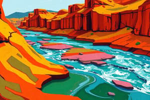
Deltas & Estuaries
- Deltas are formed where a river meets a lake or sea, depositing sediment to form a triangular or bird's foot shape
- Cuspate, arcuate, and bird's foot are various delta shapes
- Estuaries are the areas where the river flows into a sea or ocean, often a mix between freshwater and saltwater environments
Floodplains
- Large, flat areas beside rivers where the water spreads during flooding
- Formed from deposition of material carried by the river during floods
- Fertile soil, good for agriculture
- Often used as farmland
River Hazards & Opportunities
- Hazards: flooding, erosion
- Opportunities: water supply, fertile land for agriculture, building materials, transportation, recreation, energy generation
River Hazards: Flooding
- Causes: intense rainfall, high river discharge
- Effects: death, injuries, destruction of property, disruption of services
- Mitigation measures: prediction, adjustment/mitigation, construction (dams, levees).
Studying That Suits You
Use AI to generate personalized quizzes and flashcards to suit your learning preferences.