Podcast
Questions and Answers
What is the average height of the Greater Himalayas?
What is the average height of the Greater Himalayas?
- 7000m
- 8000m
- 5000m
- 6000m (correct)
What is the general orientation of the Greater Himalayas in the north-western part?
What is the general orientation of the Greater Himalayas in the north-western part?
- East-west direction
- Northwest to southeast direction (correct)
- North-south direction
- Southwest to northeast direction
What type of rocks compose the Himachal or lesser Himalayas?
What type of rocks compose the Himachal or lesser Himalayas?
- Granites
- Highly compressed and altered rocks (correct)
- Sandstones
- Limestones
What is the name of the longest range of the Himachal or lesser Himalayas?
What is the name of the longest range of the Himachal or lesser Himalayas?
What are the Outermost ranges of the Himalayas called?
What are the Outermost ranges of the Himalayas called?
What are the longitudinal valleys lying between lesser Himalayas and Shiwaliks known as?
What are the longitudinal valleys lying between lesser Himalayas and Shiwaliks known as?
What region lies south of the Terai region?
What region lies south of the Terai region?
What type of deposits are found in the Bhangar region?
What type of deposits are found in the Bhangar region?
What is the region with new alluvium deposits known as?
What is the region with new alluvium deposits known as?
What are the islands formed due to the depositional work of rivers called?
What are the islands formed due to the depositional work of rivers called?
What is the largest inhabited riverine island in the world?
What is the largest inhabited riverine island in the world?
What are the rivers in the lower course split into numerous channels due to deposition of silt called?
What are the rivers in the lower course split into numerous channels due to deposition of silt called?
What is the area behind the confluence of two rivers called?
What is the area behind the confluence of two rivers called?
What is the highest mountain peak in India and the third highest in the world?
What is the highest mountain peak in India and the third highest in the world?
Which state is home to the highest point of the Eastern Ghats?
Which state is home to the highest point of the Eastern Ghats?
What is the highest peak in the Western Ghats?
What is the highest peak in the Western Ghats?
Which pass connects Jammu and Kashmir Valley with Ladakh?
Which pass connects Jammu and Kashmir Valley with Ladakh?
Which peak is the highest point in Tamil Nadu?
Which peak is the highest point in Tamil Nadu?
Which pass connects Himachal Pradesh with Tibet?
Which pass connects Himachal Pradesh with Tibet?
Which peak is the highest point in the Andaman and Nicobar archipelago?
Which peak is the highest point in the Andaman and Nicobar archipelago?
Which pass connects Uttarakhand with Tibet?
Which pass connects Uttarakhand with Tibet?
Which peak is located in the Aravalli Range?
Which peak is located in the Aravalli Range?
What is the Peninsular Plateau composed of?
What is the Peninsular Plateau composed of?
What is the shape of the Peninsular Plateau?
What is the shape of the Peninsular Plateau?
What is the name of the plateau that lies to the south of the Narmada River?
What is the name of the plateau that lies to the south of the Narmada River?
What is the elevation of the Western Ghats compared to the Eastern Ghats?
What is the elevation of the Western Ghats compared to the Eastern Ghats?
What is the name of the range that borders the Deccan Plateau in the north and north-east?
What is the name of the range that borders the Deccan Plateau in the north and north-east?
What is the name of the plateau that is an extension of the Peninsular Plateau in the north-east?
What is the name of the plateau that is an extension of the Peninsular Plateau in the north-east?
What is the characteristic of the Western Ghats?
What is the characteristic of the Western Ghats?
What is the average elevation of the Eastern Ghats?
What is the average elevation of the Eastern Ghats?
What is the pattern of altitude in the region?
What is the pattern of altitude in the region?
Which hill range is located in the southern part of the region?
Which hill range is located in the southern part of the region?
What is the highest peak in the region?
What is the highest peak in the region?
What is the direction of flow of the rivers in the region?
What is the direction of flow of the rivers in the region?
What is the geographical feature that forms the eastern extension of the Central Highlands?
What is the geographical feature that forms the eastern extension of the Central Highlands?
What is the approximate elevation range of the Central Highlands?
What is the approximate elevation range of the Central Highlands?
What type of rocks are found in the Central Highlands?
What type of rocks are found in the Central Highlands?
What is the North-Eastern Plateau a result of?
What is the North-Eastern Plateau a result of?
Flashcards are hidden until you start studying
Study Notes
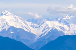
The Himalayas
- The Himalayas consists of three parallel ridges: the Greater Himalayas, the Himachal or Lesser Himalayas, and the Outer or Shiwalik Himalayas.
- The Greater Himalayas are the most continuous ranges with an average height of 6000m and consist of granites.
- The folds of the Great Himalayas are asymmetrical in nature and have a general orientation of northwest to southeast direction in the north-western part, east-west direction in Darjeeling and Sikkim Himalayas, and southwest to northeast in Arunachal Region.
- The Himachal or Lesser Himalayas are mainly composed of highly compressed and altered rocks, with the longest range being the Pir Panjal Range.
- The Outer most range of the Himalayas is called the Shiwaliks, composed of unconsolidated sediments brought down by rivers from the main Himalayan range.
- The Longitudinal valley lying between the Lesser Himalayas and the Shiwaliks is known as Duns, such as Dehra Dun, Kotli Dun, and Patli Dun.
The Terai and Bhabar Region
- The Terai region is located south of the Bhabar belt, where the streams and rivers re-emerge and create a wet, swampy, and marshy region, characterized by a thickly forested region full of wildlife.
- Bhangar is the region located south of the Terai region, formed by older alluvium, with soil containing calcareous deposits locally known as kankar.
- The region with new alluvium deposits is known as Khadar, which is renewed almost every year and is ideal for intensive cultivation.
Peaks in India
- Godwin Austen (K2) is the highest peak of the Karakoram range in Pakistan-occupied Kashmir.
- Nanga Parbat is located in Jammu and Kashmir and is the second highest mountain in India.
- Nanda Devi is located in Uttarakhand and is the highest mountain entirely within India.
- Kanchenjunga is located in Nepal and Sikkim and is the highest mountain in India and the third highest mountain in the world.
- Other notable peaks include Nokrek, Gurushikhar, Kundremukh, Doddabetta, Anaimudi, Agasthyamalai, Saddle Peak, and Mahendragiri.
Important Passes in India
- Banihal Pass is located in Jammu and Kashmir and connects Jammu to Srinagar.
- Chang-La Pass is located in Jammu and Kashmir and connects Ladakh with Tibet.
- Pir-Panjal Pass is located in Jammu and Kashmir and connects Jammu and Kashmir Valley.
- Zoji La Pass is located in Jammu and Kashmir and connects Srinagar on one side and Kargil and Leh on the other side.
- Other notable passes include Bara Lacha La, Rohtang Pass, Shipki La, Lipu Lekh, Niti Pass, Nathu La, Jelep La, Bom Di La, and Dihang Pass.
The Peninsular Plateau
- The Peninsular Plateau is formed due to the breaking and drifting of the Gondwana land and is one of the oldest and stable landmasses in India.
- It is a tableland composed of old crystalline, igneous, and metamorphic rocks.
- It is an irregular triangle in structure and extends as Delhi ridge in the north-west, Rajmahal hills in the east, Gir range in the west, and Cardamom Hills in the south.
- The important physiographic features of this region are block mountains, rift valleys, spurs, bare rocky structures, and series of hummocky hills.
The Deccan Plateau
- The Deccan Plateau is a triangular landmass that lies to the south of the Narmada River.
- It is bordered by the Western Ghats in the west, the Eastern Ghats in the east, and the Satpura, Maikal, and Mahadeo range in the north and north-eastern part.
- The plateau is higher in the west and slopes gently eastwards.
- The Western Ghats and Eastern Ghats are prominent features of the Deccan Plateau, with differences in average elevation, continuity, and peaks.
The Central Highlands
- The Central Highlands is a part of the Peninsular Plateau lying north of the Narmada River.
- It covers a major area of the Malwa plateau, Vindhyan Range, and Aravalis in the north-west.
- The plateau is wider in the west and narrower in the east.
- The general elevation ranges between 700-1000 m and slopes towards the north and north-eastern directions.
The North-Eastern Plateau
- The North-Eastern Plateau is an extension of the main peninsular plateau.
- It is believed to have been formed due to the force exerted by the north-eastward movement of the Indian plate at the time of the Himalayan origin.
- A huge fault was created between the two sides and later got filled up by the depositional activities of the rivers.
Studying That Suits You
Use AI to generate personalized quizzes and flashcards to suit your learning preferences.