Podcast
Questions and Answers
Identify the state where Mussoorie, Nainital, and Ranikhet are located.
Identify the state where Mussoorie, Nainital, and Ranikhet are located.
Uttarakhand
Name two glaciers found in the Great Himalayas.
Name two glaciers found in the Great Himalayas.
Siachen Glacier and Gangotri Glacier
What are the outer-most range of the Himalayas called?
What are the outer-most range of the Himalayas called?
Shiwaliks
What is the altitude range of the Shiwaliks?
What is the altitude range of the Shiwaliks?
What valleys are situated between the Lesser Himalaya and the Shiwaliks?
What valleys are situated between the Lesser Himalaya and the Shiwaliks?
List any two hills that are part of the Purvachal mountain range.
List any two hills that are part of the Purvachal mountain range.
What is the primary composition of the hills in the northeastern states of India?
What is the primary composition of the hills in the northeastern states of India?
What are the traditional regional names for the part of the Himalayas between the Indus and Satluj rivers?
What are the traditional regional names for the part of the Himalayas between the Indus and Satluj rivers?
What geographical features demarcate the Nepal Himalayas?
What geographical features demarcate the Nepal Himalayas?
What is the main characteristic of the Northern Plain?
What is the main characteristic of the Northern Plain?
Identify the section of the Northern Plain that is characterized by the Indus and its tributaries.
Identify the section of the Northern Plain that is characterized by the Indus and its tributaries.
What does the term 'doab' signify in geographical context?
What does the term 'doab' signify in geographical context?
Which rivers define the Ganga plain?
Which rivers define the Ganga plain?
What area does the Northern Plain cover?
What area does the Northern Plain cover?
Explain the significance of the fertile alluvial soil in the Northern Plain.
Explain the significance of the fertile alluvial soil in the Northern Plain.
What does the word 'Punjab' derive from, and what does it mean?
What does the word 'Punjab' derive from, and what does it mean?
What are the two types of soil found in the floodplain region described in the content?
What are the two types of soil found in the floodplain region described in the content?
What geological processes contributed to the formation of the Peninsular Plateau?
What geological processes contributed to the formation of the Peninsular Plateau?
Name the three prominent hill ranges within the northeastern section of the Peninsular Plateau.
Name the three prominent hill ranges within the northeastern section of the Peninsular Plateau.
What characterizes the Deccan Plateau's geography in terms of elevation?
What characterizes the Deccan Plateau's geography in terms of elevation?
Identify the two broad divisions of the Peninsular Plateau.
Identify the two broad divisions of the Peninsular Plateau.
Which ranges bound the Vindhyan range in the Peninsular Plateau?
Which ranges bound the Vindhyan range in the Peninsular Plateau?
What type of rock primarily composes the Peninsular Plateau?
What type of rock primarily composes the Peninsular Plateau?
Which rivers drain the Chotanagpur plateau region mentioned in the content?
Which rivers drain the Chotanagpur plateau region mentioned in the content?
What is the local term for calcareous deposits found in the soil of the described region?
What is the local term for calcareous deposits found in the soil of the described region?
Describe the valleys and hills found in the Peninsular Plateau.
Describe the valleys and hills found in the Peninsular Plateau.
What geological origin do the Deccan Trap rocks have and what type of soil do they contribute to?
What geological origin do the Deccan Trap rocks have and what type of soil do they contribute to?
Identify the coastal sections of the western coast of India mentioned and their respective locations.
Identify the coastal sections of the western coast of India mentioned and their respective locations.
Describe the climatic conditions of the Indian desert and its effect on vegetation.
Describe the climatic conditions of the Indian desert and its effect on vegetation.
What is the significance of the Aravali Hills in the geography of the Peninsular plateau?
What is the significance of the Aravali Hills in the geography of the Peninsular plateau?
What is the main feature of the sandy plains covered with dunes in the Indian desert?
What is the main feature of the sandy plains covered with dunes in the Indian desert?
What differentiates the average elevation of the Western Ghats from that of the Eastern Ghats?
What differentiates the average elevation of the Western Ghats from that of the Eastern Ghats?
Identify the major rivers draining the region that is associated with the Central Highlands.
Identify the major rivers draining the region that is associated with the Central Highlands.
Explain how the Western Ghats contribute to rainfall in the region.
Explain how the Western Ghats contribute to rainfall in the region.
What is the highest peak in the Eastern Ghats, and how tall is it?
What is the highest peak in the Eastern Ghats, and how tall is it?
Describe the geographical characteristics of the Eastern Ghats.
Describe the geographical characteristics of the Eastern Ghats.
What local names are given to the eastward extensions of the Central Highlands?
What local names are given to the eastward extensions of the Central Highlands?
How do the heights of the Western Ghats change from north to south?
How do the heights of the Western Ghats change from north to south?
What role does the Thal, Bhor, and Pal Ghats play in the geography of India?
What role does the Thal, Bhor, and Pal Ghats play in the geography of India?
What characterizes the flow of rivers in the Central Highlands?
What characterizes the flow of rivers in the Central Highlands?
How is the geographical continuity of the Western Ghats described?
How is the geographical continuity of the Western Ghats described?
Flashcards
Shiwaliks
Shiwaliks
The outermost range of the Himalayas, characterized by low altitudes (900-1100 meters) and composed of unconsolidated sediments deposited by rivers.
Duns
Duns
Longitudinal valleys located between the Lesser Himalayas and the Shiwaliks, filled with gravel and alluvium.
Dehra Dun
Dehra Dun
A well-known 'Dun' located in Uttarakhand, India.
Purvachal (Eastern Himalayas)
Purvachal (Eastern Himalayas)
Signup and view all the flashcards
Patkai Hills
Patkai Hills
Signup and view all the flashcards
Naga Hills
Naga Hills
Signup and view all the flashcards
Manipur Hills
Manipur Hills
Signup and view all the flashcards
Punjab Himalaya
Punjab Himalaya
Signup and view all the flashcards
Kumaon Himalayas
Kumaon Himalayas
Signup and view all the flashcards
Nepal Himalayas
Nepal Himalayas
Signup and view all the flashcards
Assam Himalayas
Assam Himalayas
Signup and view all the flashcards
The Northern Plain
The Northern Plain
Signup and view all the flashcards
Punjab Plains
Punjab Plains
Signup and view all the flashcards
Ganga Plain
Ganga Plain
Signup and view all the flashcards
Alluvium Deposition
Alluvium Deposition
Signup and view all the flashcards
Khadar
Khadar
Signup and view all the flashcards
Bhangar
Bhangar
Signup and view all the flashcards
Deccan Plateau
Deccan Plateau
Signup and view all the flashcards
Central Highlands
Central Highlands
Signup and view all the flashcards
Eastern Ghats
Eastern Ghats
Signup and view all the flashcards
Western Ghats
Western Ghats
Signup and view all the flashcards
Malwa Plateau
Malwa Plateau
Signup and view all the flashcards
Chotanagpur Plateau
Chotanagpur Plateau
Signup and view all the flashcards
Northeastern Hills
Northeastern Hills
Signup and view all the flashcards
Peninsular Plateau
Peninsular Plateau
Signup and view all the flashcards
Deccan Trap
Deccan Trap
Signup and view all the flashcards
Western Coastal Plain
Western Coastal Plain
Signup and view all the flashcards
Indian Desert
Indian Desert
Signup and view all the flashcards
Aravali Hills
Aravali Hills
Signup and view all the flashcards
Rajasthan Desert
Rajasthan Desert
Signup and view all the flashcards
Slope
Slope
Signup and view all the flashcards
Orographic rain
Orographic rain
Signup and view all the flashcards
Anai Mudi
Anai Mudi
Signup and view all the flashcards
Mahendragiri
Mahendragiri
Signup and view all the flashcards
Doda Betta
Doda Betta
Signup and view all the flashcards
Rain-bearing winds
Rain-bearing winds
Signup and view all the flashcards
Study Notes
Physical Features of India
- India has a diverse range of landforms such as mountains, plains, deserts, plateaus, and islands.
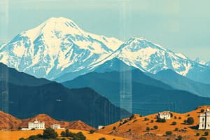
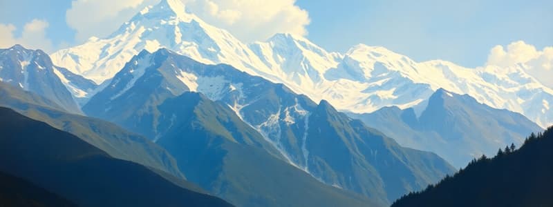
- The Himalayan Mountains are young, fold mountains running west to east, from the Indus to the Brahmaputra. They represent the world's most rugged mountain barriers.
- The Himalayas have three parallel ranges: the Great Himalayas (Himadri), the Lesser Himalayas (Himachal), and the Shiwaliks.
- The Great Himalayas are the loftiest, with an average height of 6,000 meters.
- The Northern Plains are formed from alluvial deposits of the Indus, Ganga, and Brahmaputra rivers and their tributaries over millions of years.
- The Northern Plains are around 7 lakh sq km and are densely populated with rich soil and favorable climate.
- The Peninsular Plateau is one of the oldest landmasses on earth, composed of igneous and metamorphic rocks.
- The Peninsular Plateau has two main divisions: the Central Highlands and the Deccan Plateau.
- The Western Ghats and Eastern Ghats mark the western and eastern edges of the Deccan Plateau, respectively. The Western Ghats are higher than the Eastern Ghats.
- The Western Ghats are crucial for the orographic rainfall.
- The Indian Desert, located in western Rajasthan, is an undulating sandy plain with very low rainfall.
- The Coastal Plains are narrow strips along the Arabian Sea and Bay of Bengal, formed by the deposition of sediments from rivers.
- The islands of India include the Andaman and Nicobar Islands, and the Lakshadweep Islands. The Andaman and Nicobar Islands are larger than the Lakshadweep Islands.
- The Lakshadweep Islands are composed of small coral islands.
- The Himalayas, geologically young, have high peaks and deep valleys that are formed of unconsolidated sediments brought down by rivers from the main ranges.
- The Himalayas have diverse longitudinal and regional divisions.
- The Northern Plains are a flat, fertile area formed by alluvial deposits from rivers.
Major Physiographic Divisions of India
- Himalayan Mountains
- Northern Plains
- Peninsular Plateau
- Indian Desert
- Coastal Plains
- Islands
Studying That Suits You
Use AI to generate personalized quizzes and flashcards to suit your learning preferences.