Podcast
Questions and Answers
What is the geographical area of Jammu and Kashmir?
What is the geographical area of Jammu and Kashmir?
- 42,241 km² (correct)
- 591,462 km²
- 35,000 km²
- 76,000 km²
Which region has the highest elevation in Jammu and Kashmir?
Which region has the highest elevation in Jammu and Kashmir?
- Nun Peak (correct)
- Ladakh Plateau
- Outer Plains
- Kashmir Valley
Which of the following is NOT one of the physiographic divisions of Jammu and Kashmir?
Which of the following is NOT one of the physiographic divisions of Jammu and Kashmir?
- Indus Valley (correct)
- Valley of Kashmir
- Greater Himalayas
- Foothills (Shiwaliks)
What natural feature predominantly influences the formation of the plains in Jammu and Kashmir?
What natural feature predominantly influences the formation of the plains in Jammu and Kashmir?
Which valley is NOT mentioned as part of Jammu and Kashmir?
Which valley is NOT mentioned as part of Jammu and Kashmir?
What is a local name for the outer plains of Jammu and Kashmir?
What is a local name for the outer plains of Jammu and Kashmir?
Which river is NOT mentioned as contributing to the plains of Jammu and Kashmir?
Which river is NOT mentioned as contributing to the plains of Jammu and Kashmir?
Which physiographic division is characterized by the highest peaks in Jammu and Kashmir?
Which physiographic division is characterized by the highest peaks in Jammu and Kashmir?
What is the altitude range of the Shiwaliks?
What is the altitude range of the Shiwaliks?
Which materials primarily compose the Duns formed between the Shiwaliks and Lesser Himalayas?
Which materials primarily compose the Duns formed between the Shiwaliks and Lesser Himalayas?
Which range is known as the longest range in the Lesser Himalayas?
Which range is known as the longest range in the Lesser Himalayas?
What is the average elevation range of the Lesser Himalayas?
What is the average elevation range of the Lesser Himalayas?
What are the Kandi regions known for?
What are the Kandi regions known for?
Where is the hill station of Gulmarg located?
Where is the hill station of Gulmarg located?
Which pass connects the Kashmir valley with Rajouri and Poonch?
Which pass connects the Kashmir valley with Rajouri and Poonch?
Which river does not have its source in the Lesser Himalayas?
Which river does not have its source in the Lesser Himalayas?
What is the average height range of the Greater Himalayas?
What is the average height range of the Greater Himalayas?
Which mountain range separates Zanskar from Ladakh?
Which mountain range separates Zanskar from Ladakh?
Where does the Ladakh Range extend to in the southeast?
Where does the Ladakh Range extend to in the southeast?
What is another name for Karakorum mountain range?
What is another name for Karakorum mountain range?
Which peak is located in the Greater Himalayas range?
Which peak is located in the Greater Himalayas range?
Which of the following passes is NOT located in the Zanskar Range?
Which of the following passes is NOT located in the Zanskar Range?
What is the primary purpose of the Jawahar Tunnel?
What is the primary purpose of the Jawahar Tunnel?
What is the elevation of Leh town in the Upper Indus Valley?
What is the elevation of Leh town in the Upper Indus Valley?
Which of the following tunnels is recognized as India's longest railway tunnel?
Which of the following tunnels is recognized as India's longest railway tunnel?
Which pass is part of the Ladakh Range?
Which pass is part of the Ladakh Range?
What geological features are referred to as Karewas in the Valley of Kashmir?
What geological features are referred to as Karewas in the Valley of Kashmir?
Which pass connects Banihal with Qazigund?
Which pass connects Banihal with Qazigund?
What type of deposits are found in the Karewas?
What type of deposits are found in the Karewas?
Which valley is not listed as a side valley within the Valley of Kashmir?
Which valley is not listed as a side valley within the Valley of Kashmir?
What significant geological event contributed to the drainage of water from the Kashmir Valley?
What significant geological event contributed to the drainage of water from the Kashmir Valley?
What is the approximate length of the Atal Tunnel?
What is the approximate length of the Atal Tunnel?
What is the highest peak in the Karakoram mountain range?
What is the highest peak in the Karakoram mountain range?
Which passes are used for traveling from Ladakh to Chinese Turkistan?
Which passes are used for traveling from Ladakh to Chinese Turkistan?
Which mountain range includes Nanga Parbat?
Which mountain range includes Nanga Parbat?
Which region is primarily controlled by India in the Depsang Plains area?
Which region is primarily controlled by India in the Depsang Plains area?
What does the acronym SSN stand for in the context of Indian military terminology?
What does the acronym SSN stand for in the context of Indian military terminology?
Which mountain is NOT mentioned as part of the Jammu and Kashmir mountain ranges?
Which mountain is NOT mentioned as part of the Jammu and Kashmir mountain ranges?
What height defines the majority of summits in the Karakoram range?
What height defines the majority of summits in the Karakoram range?
What geographical feature primarily lies north of the Depsang Plains?
What geographical feature primarily lies north of the Depsang Plains?
Which mountain is the tallest peak in Jammu and Kashmir?
Which mountain is the tallest peak in Jammu and Kashmir?
What separates the Suru and Zanskar Valleys?
What separates the Suru and Zanskar Valleys?
Which of the following volcanic peaks is considered dormant?
Which of the following volcanic peaks is considered dormant?
Which pass is situated between Leh and Kullu?
Which pass is situated between Leh and Kullu?
What describes Kharewa peak?
What describes Kharewa peak?
What are the names of the important passes in Toshmaidan and Kajinag?
What are the names of the important passes in Toshmaidan and Kajinag?
In which year did Soyamji volcanic peak erupt for 13 months?
In which year did Soyamji volcanic peak erupt for 13 months?
Which mountain range do Toshmaidan and Kajinag belong to?
Which mountain range do Toshmaidan and Kajinag belong to?
Flashcards
Shiwaliks
Shiwaliks
The foothills of the Himalayas, composed of younger tertiary rocks.
Width of Shiwaliks
Width of Shiwaliks
Between 20 to 50 km in certain states.
Shiwalik altitude
Shiwalik altitude
600-1200 meters (2000-4000ft) in height.
Duns
Duns
Signup and view all the flashcards
Lesser Himalayas
Lesser Himalayas
Signup and view all the flashcards
Pir Panjal
Pir Panjal
Signup and view all the flashcards
Dhauladhar
Dhauladhar
Signup and view all the flashcards
Elevation of Lesser Himalayas
Elevation of Lesser Himalayas
Signup and view all the flashcards
Kandi
Kandi
Signup and view all the flashcards
Latitude of Jammu and Kashmir
Latitude of Jammu and Kashmir
Signup and view all the flashcards
Longitude of Jammu and Kashmir
Longitude of Jammu and Kashmir
Signup and view all the flashcards
Area of Jammu and Kashmir
Area of Jammu and Kashmir
Signup and view all the flashcards
State Boundaries of Jammu and Kashmir
State Boundaries of Jammu and Kashmir
Signup and view all the flashcards
Physiographic Divisions of J&K
Physiographic Divisions of J&K
Signup and view all the flashcards
Outer Plains (Jammu and Kashmir)
Outer Plains (Jammu and Kashmir)
Signup and view all the flashcards
Foothills (Shiwaliks)
Foothills (Shiwaliks)
Signup and view all the flashcards
Lesser Himalayas (Pir Panjal)
Lesser Himalayas (Pir Panjal)
Signup and view all the flashcards
Kashmir Valley
Kashmir Valley
Signup and view all the flashcards
Greater Himalayas
Greater Himalayas
Signup and view all the flashcards
The Karakoram Region
The Karakoram Region
Signup and view all the flashcards
Ladakh Plateau
Ladakh Plateau
Signup and view all the flashcards
Khads
Khads
Signup and view all the flashcards
Banihal Pass
Banihal Pass
Signup and view all the flashcards
Jawahar Tunnel
Jawahar Tunnel
Signup and view all the flashcards
Banihal-Qazigund Road Tunnel
Banihal-Qazigund Road Tunnel
Signup and view all the flashcards
Atal Tunnel
Atal Tunnel
Signup and view all the flashcards
Banihal Railway Tunnel
Banihal Railway Tunnel
Signup and view all the flashcards
Sinthan Pass
Sinthan Pass
Signup and view all the flashcards
Valley of Kashmir
Valley of Kashmir
Signup and view all the flashcards
Karewas
Karewas
Signup and view all the flashcards
Nun Kun Mountain
Nun Kun Mountain
Signup and view all the flashcards
Suru Valley
Suru Valley
Signup and view all the flashcards
Zanskar Range
Zanskar Range
Signup and view all the flashcards
Toshmaidan and Kajinag
Toshmaidan and Kajinag
Signup and view all the flashcards
Soyamji Volcanic Peak
Soyamji Volcanic Peak
Signup and view all the flashcards
Kharewa Peak
Kharewa Peak
Signup and view all the flashcards
Karewas
Karewas
Signup and view all the flashcards
Side Valleys
Side Valleys
Signup and view all the flashcards
Kashmir Valley
Kashmir Valley
Signup and view all the flashcards
Greater Himalayas
Greater Himalayas
Signup and view all the flashcards
Zanskar Range
Zanskar Range
Signup and view all the flashcards
Ladakh Range
Ladakh Range
Signup and view all the flashcards
Upper Indus Valley
Upper Indus Valley
Signup and view all the flashcards
Karakoram Range
Karakoram Range
Signup and view all the flashcards
Karakoram Range Location
Karakoram Range Location
Signup and view all the flashcards
Karakoram Range Height
Karakoram Range Height
Signup and view all the flashcards
Karakoram Range Key Peaks
Karakoram Range Key Peaks
Signup and view all the flashcards
Karakoram Pass Usage
Karakoram Pass Usage
Signup and view all the flashcards
Depsang Plains Location
Depsang Plains Location
Signup and view all the flashcards
Depsang Plains Significance
Depsang Plains Significance
Signup and view all the flashcards
Kashmir Valley Surroundings
Kashmir Valley Surroundings
Signup and view all the flashcards
Study Notes
Physiography of Jammu and Kashmir
- Jammu and Kashmir is a union territory in northern India, situated in the Himalayas.
- Created on October 31, 2019.
- Capital: Srinagar (summer) and Jammu (winter).
- Total geographical area: 42,241 km².
- Total population: 12,267,013.
- Population density: 290/km².
- Districts: 20.
- Secretariat: Jammu and Srinagar.
- High Court: High Court of Jammu and Kashmir and Ladakh.
- Official languages: Kashmiri, Dogri, Urdu, Hindi, and English.
UT Symbols
- UT Animal: Hangul (Kashmir Stag), a critically endangered subspecies of elk found in Dachigam National Park.
- UT Bird: The Khalij Pheasant, found in forests and thickets from Pakistan to western Thailand. Declared official UT bird on October 21, 2021.
- UT Tree: The Chinar tree (Platanus orientalis). Also known as Booune in Kashmiri.
- UT Flower: The Lotus (Nelumbo nucifera).
- UT Emblem: The government of Jammu and Kashmir uses the words "Government of Jammu and Kashmir" on official documents, either alone or in conjunction with the National Emblem of India.
Location
- Situated in the northern part of India in the Himalayas.
- Latitude: 32° 17' N - 35° 10' N.
- Longitude: 73° 26' E - 76° 20' E.
- Area: 42,241 km².
- Borders: Himachal Pradesh and Punjab in the south, Ladakh UT in the north/east, and partially under Pakistan's control.
- Geographical size: Second-largest UT after Ladakh, and Delhi.
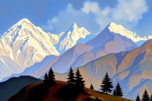
Physiographic Divisions
- Jammu and Kashmir is a mountainous region with variations in height from 914 m to 7135 m (Nun Peak).
- The UT is divided into seven physiographic divisions.
- These divisions include: Outer Plains, Foothills (Shiwaliks), Lesser Himalayas (Pir Panjal), Valley of Kashmir, Greater Himalayas, The Karakoram Region, and Ladakh Plateau.
Plains
- The plains were formed by the erosion of bedrock material carried by rivers like the Chenab, Ravi, Tawi, Ujh, and Basantar.
- These plains are in the southern parts of Jammu and Kashmir.
- The outer plains are locally known as "Andarwah" or "Bajwat," featuring numerous hill torrents.
- Seasonal torrents ("Khads") characterize these areas.
Foothills (Shiwaliks)
- The Shiwaliks are the foothills of the Himalayas, composed of younger tertiary rocks.
- Width: 20 to 50 km.
- Altitude: 600–1200 m.
- Includes long ridges, longitudinal valleys, and Duns (e.g., Udhampur, Bhasoli, Kotli).
Lesser Himalayas
- Also known as Middle Himalayas, lying between the Ravi River in the east and the Poonch in the west.
- Composed of volcanic rocks, granite, gneiss, quartz, etc.
- Average elevation: 3,600–4,600 meters.
- Major ranges: Pir Panjal (longest and Westernmost), Dhauladhar.
- Features: Vaishno Devi cave.
- Rivers sourced here: Tawi, Manawar-Tawi, Basantra, and Ujh rivers.
Valley of Kashmir
- A deep, asymmetrical basin between Pir Panjal and the Western Himalayas.
- Filled with lake sediments and alluvial deposits from the upper Jhelum River.
- Features extensive plateaus of alluvial and lacustrine material (Karewas).
- Contains important side valleys like Lidder valley and Sind valley.
Karewas (Wudurs)
- Are lacustrine deposits (deposits in lakes) found in the Kashmir Valley and Bhadarwah Valley.
- They are flat-topped mounds of loamy soil encompassing the Kashmir Valley.
- Geologists believe they formed from the filling of the Kashmir valley by water from the Tethys Sea during the Pleistocene period.
- Later, river drainage created the present terrain with deposits.
Greater Himalayas
- Located North of the Pir Panjal and Dhauladhar ranges.
- Average elevation: 4,500–6,100 m.
- Zanskar and other ranges found here (with peaks like Kun and Nun).
- Also includes Nanga Parbat for its elevation.
Zanskar Range
- A mountain range within the Tethys Himalaya, separating the Zanskar region from Ladakh.
- Contains high peaks.
- Important passes (like Marbal, Zojila, Fotu, Namika, Pensi).
Ladakh Range
- A southern extension of the Karakoram Range.
- Stretching 230 miles/370 km from Indus-Shyok confluence to the Tibetan border.
- Includes the main mountain passes: Chorbat, Digar La, Khardungi La, Chang La, Umling La, and Tsaka La.
Upper Indus Valley
- Includes areas from the Tibetan border to the point in the Pakistani region of Kashmir, westwards.
- Tributary rivers form alluvial fans in the main valley.
- Leh town is in this valley (at an elevation of 3500 m).
Karakorum
- A substantial portion is under Gilgit-Baltistan (controlled by Pakistan).
- Also known as the Mount Godwin-Austen/Chogori/Savage Mountains.
- The range's high peaks (like K2, Gasherbrum, Masherbrum) are globally significant.
- Passes: Karakorum Pass, Nubra.
Ladakh Plateau
- A high-altitude, gravelly plain in the northwest portion of Aksai Chin, bordering Tibet.
- Includes the Depsang Plains, which are geographically important.
- Important passes: Karakoram Pass, Lingi Tang Plains, etc.
Mountains of Jammu and Kashmir
- Kashmir Valley surrounded by high mountains.
- Important mountains and ranges: Amarnath, Afarwat, Burzil, Karakoram, Nanga Parbat, Harmukh Mountain, Nun Kun, Pir Panjal, Shiwalik, Toshmaidan, Kajinag, Soyamji Peak, Kharewa.
Volcanic Mountains
- Soyamji and Kharewa are dormant volcanic peaks in Jammu and Kashmir.
- The lecturer cites the eruption of Soyamji in 1934.
Studying That Suits You
Use AI to generate personalized quizzes and flashcards to suit your learning preferences.