Podcast
Questions and Answers
Which region in India is often referred to as the 'granary of India'?
Which region in India is often referred to as the 'granary of India'?
- Himalayan Region
- Indo-Gangetic Plain (correct)
- Coastal Plains
- Deccan Plateau
Which physiographic division of India includes states like Uttar Pradesh and Himachal Pradesh?
Which physiographic division of India includes states like Uttar Pradesh and Himachal Pradesh?
- Indo-Gangetic Plain
- Himalayan Region (correct)
- Coastal Plains
- Deccan Plateau
Which region in India is known for its flat terrain and fertile soil?
Which region in India is known for its flat terrain and fertile soil?
- Himalayan Region
- Indo-Gangetic Plain
- Deccan Plateau
- Coastal Plains (correct)
Which part of India experiences extreme cold winters?
Which part of India experiences extreme cold winters?
Which area in India is famous for massive plateaus like the Deccan Plateau?
Which area in India is famous for massive plateaus like the Deccan Plateau?
Which physiographic division in India includes the Satpura Range?
Which physiographic division in India includes the Satpura Range?
Which river originates in Maharashtra and flows through Telangana, Andhra Pradesh, Maharashtra, and Karnataka?
Which river originates in Maharashtra and flows through Telangana, Andhra Pradesh, Maharashtra, and Karnataka?
Where is Mount Everest located, the highest mountain in the world?
Where is Mount Everest located, the highest mountain in the world?
Which river flows through Ladakh, Jammu and Kashmir, Himachal Pradesh, and Pakistan before reaching the Arabian Sea?
Which river flows through Ladakh, Jammu and Kashmir, Himachal Pradesh, and Pakistan before reaching the Arabian Sea?
In which range is Kanger Dhubi, the highest peak located?
In which range is Kanger Dhubi, the highest peak located?
Which river joins the Ganga after flowing through Uttarakhand, Bihar, and West Bengal?
Which river joins the Ganga after flowing through Uttarakhand, Bihar, and West Bengal?
Where is Nanda Devi, the highest peak in the Western Ghats located?
Where is Nanda Devi, the highest peak in the Western Ghats located?
Flashcards are hidden until you start studying
Study Notes
Geography of India
India is located in South Asia and is the seventh largest country by land area. It shares its borders with Pakistan, China, Nepal, Bhutan, Bangladesh, and Myanmar. The topography of India varies greatly due to its diverse range of climates. The northern part of the country experiences extreme cold winters while the southern region has tropical climate. The Indian Peninsula extends southwards into the Indian Ocean forming the states of Tamil Nadu, Karnataka, Goa, Kerala, and Lakshadweep.
The five major physiographic divisions of India are:
- Himalayan Region: This includes Uttar Pradesh, Himachal Pradesh, Jammu & Kashmir, Sikkim, Arunachal Pradesh, Ladakh, and parts of Punjab and Rajasthan. The Himalayas, which are part of this region, have played a crucial role in shaping India's history since ancient times.
- Deccan Plateau: This covers parts of Andhra Pradesh, Telangana, Maharashtra, Karnataka, Madhya Pradesh, Chhattisgarh, Odisha, Jharkhand, West Bengal, Bihar, Uttar Pradesh, and eastern Uttar Pradesh. It is known for the formation of massive plateaus such as the Deccan Plateau and Satpura Range.
- Coastal Plains: Comprising the coastal regions of Gujarat, Maharashtra, Tamil Nadu, Kerala, and West Bengal. These plains are characterized by their flat terrain and fertile soil.
- Indo-Gangetic Plain: Often referred to as the 'granary of India', this region lies between the western border of India and the Himalayas. It stretches from Punjab in the northwest to Bihar in the east. The plain is formed by alluvial deposits brought down by the Ganga river system.
- Islands: Including the archipelago of Andaman and Nicobar Islands and the islands of Lakshadweep, these territories are situated in the Bay of Bengal and Arabian Sea respectively.
Rivers in India
India has a vast network of rivers, with some of them being perennial while others are seasonal. Some of the major rivers in India include:
- River Indus: Originating in Tibet, it flows through Ladakh, Jammu and Kashmir, Himachal Pradesh, and Pakistan before flowing into the Arabian Sea.
- River Ganga: Known as the 'Ganges', it originates at Gaumukh in the Himalayas and flows through Uttarakhand, Bihar, and West Bengal before joining the Bay of Bengal.
- River Yamuna: Originating in the Himalayas, it flows through Uttarakhand, Uttar Pradesh, and Delhi before joining the Ganga.
- River Brahmaputra: Originating in Tibet, it flows through Assam and West Bengal before joining the Ganga.
- River Godavari: Originating in Maharashtra, it flows through Telangana, Andhra Pradesh, Maharashtra, and Karnataka.
- River Narmada: Originating in Madhya Pradesh, it flows through Gujarat, Madhya Pradesh, and Maharashtra.
- River Kaveri: Originating in Karnataka, it flows through Tamil Nadu.
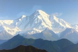
Mountains in India
India has a diverse range of mountains, including the Himalayas, the Western Ghats, the Satpura Range, and the Vindhya Range. Some of the major mountains in India include:
- Mount Everest: The highest mountain in the world, it is located in the Himalayas.
- Kanchenjunga: The second highest mountain in the world, it is located in the Himalayas.
- Nanda Devi: The highest peak in the Western Ghats, it is located in Uttarakhand.
- Anamudi: The highest peak in the Western Ghats, it is located in Kerala.
- Kanger Dhubi: The highest peak in the Vindhya Range, it is located in Madhya Pradesh.
These mountains play a crucial role in shaping India's geography and climate. They also have significant cultural and religious significance for the people of India.
Studying That Suits You
Use AI to generate personalized quizzes and flashcards to suit your learning preferences.