Podcast
Questions and Answers
What geographical feature acts as India's northern boundary?
What geographical feature acts as India's northern boundary?
- Coastal Plains
- Indo-Gangetic Plain
- Thar Desert
- Himalayas (correct)
Which river's mouth is located in the Bay of Bengal and serves as an eastern extreme point of India?
Which river's mouth is located in the Bay of Bengal and serves as an eastern extreme point of India?
- Indus River
- Kaveri River
- Ganges River
- Brahmaputra River (correct)
What type of climate is primarily influenced by monsoon winds in India?
What type of climate is primarily influenced by monsoon winds in India?
- Subarctic climate
- Mediterranean climate
- Tropical wet and dry climate (correct)
- Oceanic climate
Which plateau is known as the prominent extensive plateau in central and southern India?
Which plateau is known as the prominent extensive plateau in central and southern India?
What is a major challenge faced by India's river systems that affects agriculture and transportation?
What is a major challenge faced by India's river systems that affects agriculture and transportation?
Which of the following resources is unevenly distributed across India and is crucial for agriculture?
Which of the following resources is unevenly distributed across India and is crucial for agriculture?
What major natural feature is primarily found in the northwest region of India?
What major natural feature is primarily found in the northwest region of India?
Which region of India is characterized by being the most densely populated?
Which region of India is characterized by being the most densely populated?
Flashcards
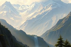
Himalayas
Himalayas
The Himalayas form India's northern border, impacting its climate and rivers. This range includes peaks over 8,000 meters high.
Indo-Gangetic Plain
Indo-Gangetic Plain
A vast fertile plain produced by the Indus, Ganges, and Brahmaputra rivers. This plain is essential for India's agriculture.
Coastal Plains
Coastal Plains
These plains stretch along India's coastline, with varying widths. They are important for fishing and coastal industries.
Deserts
Deserts
Signup and view all the flashcards
Plateaus
Plateaus
Signup and view all the flashcards
Monsoon Winds
Monsoon Winds
Signup and view all the flashcards
Climate of India
Climate of India
Signup and view all the flashcards
Mineral Resources
Mineral Resources
Signup and view all the flashcards
Study Notes
Location and Extent
- India is located in South Asia, bordered by the Indian Ocean on the south.
- It stretches from the Himalayas in the north to the Indian Ocean in the south.
- Its extreme points are:
- North: Indus River source near Mansarovar
- South: Kanyakumari
- East: Brahmaputra River mouth in the Bay of Bengal
- West: Kutch Peninsula's westernmost point
Physical Features
- Himalayas: A major mountain range forming India's northern boundary, influencing climate and river systems.
- Contains several peaks over 8,000 meters above sea level.
- Indo-Gangetic Plain: A vast fertile plain formed by the Indus, Ganges, and Brahmaputra rivers.
- Coastal Plains: Stretching along the Indian Ocean's coastline and varying in width.
- Deserts: Thar Desert stretching from the northwest, mainly comprising arid and semi-arid landforms.
- Plateaus: Deccan Plateau is a prominent, extensive plateau in the central and southern parts.
- Includes plateaus of various smaller sizes across the country.
Drainage Systems
- Key rivers: Indus, Ganges, Brahmaputra, and their tributaries.
- River systems support agriculture and transportation, often facing challenges like floods and droughts.
Climate
- India's climate is influenced by diverse geographical elements, resulting in varied regional climates.
- Monsoon winds are a defining feature, influencing rainfall patterns and agricultural activities.
- Categorized into wet and dry seasons, with significant variations across regions.
- Significant variations in temperature across regions, influenced by altitude and proximity to the sea.
Natural Resources
- Variety of mineral resources including coal, iron ore, manganese, and bauxite.
- Significant forest resources, providing biodiversity and contributing to the economy.
- Water resources are crucial for agriculture and other needs, though distributed unevenly.
- Significance of damming and irrigation projects to manage water resources.
Important Geographical Divisions
- Himalayan region, with diverse flora and fauna; unique ecosystem.
- Northern Plains, the most densely populated region.
- Large agricultural tracts and extensive human habitation.
- Western and Eastern Coastal Plains, support fishing and coastal industries.
- Deccan Plateau, also known for agriculture and mineral deposits.
- Significant rainfall from monsoons, affecting agricultural patterns.
- Thar Desert, specific environmental challenges affecting agriculture and human settlement.
Islands
- Lakshadweep and Andaman and Nicobar Islands are archipelagoes of the Indian Ocean.
- Unique biodiversity, impacted by various natural factors and human interventions.
Political and Economic Importance
- Geographical features impact national borders and defense strategies.
- Resources influence industrial and economic development.
- Infrastructure development is guided by geographical considerations.
- Road, rail, and water transport networks are influenced by the landscape and resources.
Studying That Suits You
Use AI to generate personalized quizzes and flashcards to suit your learning preferences.
Description
This quiz explores the geographical features of India, including its location, extreme points, and various physical landscapes. Test your knowledge on the Himalayas, Indo-Gangetic Plain, coastal areas, deserts, and plateaus. Learn how these features shape the country's environment and climate.