Podcast
Play an AI-generated podcast conversation about this lesson
Questions and Answers
What is the highest peak in the Himalayan Mountains?
What is the highest peak in the Himalayan Mountains?
- Kangchenjunga
- Lhotse
- K2
- Mount Everest (correct)
Which rivers contribute to the formation of the Indus-Ganga Plain?
Which rivers contribute to the formation of the Indus-Ganga Plain?
- Ganges, Yamuna, Brahmaputra
- Godavari, Krishna, Kaveri
- Brahmaputra, Sutlej, Ravi
- Indus, Ganges, Brahmaputra (correct)
What is the average elevation of the Deccan Plateau?
What is the average elevation of the Deccan Plateau?
- 200-300 meters
- 600-700 meters
- 500-600 meters (correct)
- 400-500 meters
Which of the following characteristics is associated with the Desert Region of India?
Which of the following characteristics is associated with the Desert Region of India?
Signup and view all the answers
What type of crops is predominantly grown in the Indus-Ganga Plain?
What type of crops is predominantly grown in the Indus-Ganga Plain?
Signup and view all the answers
Which geographical feature bounds the Deccan Plateau?
Which geographical feature bounds the Deccan Plateau?
Signup and view all the answers
How long does the Himalayan Mountain range extend?
How long does the Himalayan Mountain range extend?
Signup and view all the answers
Flashcards are hidden until you start studying
Study Notes
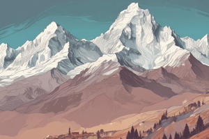
Himalayan Mountains
- World's highest and youngest mountain range
- Stretch for over 2,500 km from Pakistan to Myanmar
- Average height: 6,000-7,000 meters
- Highest peak: Mount Everest (8,848 meters)
- Home to several sacred rivers, including the Ganges and Brahmaputra
- Climatic influence: blocks cold winds from Central Asia, creating a subtropical climate in the northern plains
Indus-Ganga Plain
- Largest alluvial plain in the world
- Stretches from the Himalayas to the Arabian Sea
- Covers over 700,000 km²
- Formed by the Indus, Ganges, and Brahmaputra rivers
- Fertile and densely populated region
- Supports a wide range of crops, including rice, wheat, and sugarcane
Deccan Plateau
- Triangular plateau covering central India
- Bounded by the Western and Eastern Ghats
- Average elevation: 500-600 meters
- Composed of volcanic rocks and lava flows
- Home to several major rivers, including the Godavari, Krishna, and Kaveri
- Rich in mineral resources, including iron ore, coal, and diamonds
Desert Region
- Covers over 10% of India's land area
- Located in the northwestern parts of the country
- Characterized by hot and dry climate
- Receives very little rainfall (<25 cm per year)
- Thar Desert (also known as the Great Indian Desert) is the largest desert region
- Supports limited vegetation and wildlife
Coastal Regions
- India has a long coastline of over 7,500 km
- Divided into two main regions: the Western Coastal Plain and the Eastern Coastal Plain
- Western Coastal Plain: narrow and rocky, with a few natural harbors
- Eastern Coastal Plain: broader and more fertile, with several major deltas
- Home to several major ports, including Mumbai and Chennai
- Supports a wide range of marine life and fisheries
The Islands
- India has two major island groups: the Andaman and Nicobar Islands and the Lakshadweep Islands
- Andaman and Nicobar Islands: located in the Bay of Bengal, known for their dense forests and diverse wildlife
- Lakshadweep Islands: located in the Arabian Sea, known for their coral reefs and marine biodiversity
- Both island groups are union territories and are of strategic importance to India
Himalayan Mountains
- The world's highest and youngest mountain range, stretching over 2,500 km from Pakistan to Myanmar
- Average height is 6,000-7,000 meters with the highest peak being Mount Everest at 8,848 meters
- Home to several sacred rivers, including the Ganges and Brahmaputra
- Plays a crucial role in shaping the climate, blocking cold winds from Central Asia and creating a subtropical climate in the northern plains
Indus-Ganga Plain
- The largest alluvial plain in the world, stretching from the Himalayas to the Arabian Sea
- Covers an area of over 700,000 km², formed by the Indus, Ganges, and Brahmaputra rivers
- Fertile and densely populated region, supporting a wide range of crops including rice, wheat, and sugarcane
Deccan Plateau
- A triangular plateau covering central India, bounded by the Western and Eastern Ghats
- Average elevation is 500-600 meters, composed of volcanic rocks and lava flows
- Home to several major rivers, including the Godavari, Krishna, and Kaveri
- Rich in mineral resources, including iron ore, coal, and diamonds
Desert Region
- Covers over 10% of India's land area, located in the northwestern parts of the country
- Characterized by a hot and dry climate, receiving very little rainfall
Studying That Suits You
Use AI to generate personalized quizzes and flashcards to suit your learning preferences.