Podcast
Play an AI-generated podcast conversation about this lesson
Download our mobile app to listen on the go
Get App
Questions and Answers
What is the approximate length of the Himalayan Mountains?
What is the approximate length of the Himalayan Mountains?
- 1,500 km
- 2,500 km (correct)
- 3,000 km
- 4,000 km
What is the primary reason for the formation of the Himalayan Mountains?
What is the primary reason for the formation of the Himalayan Mountains?
- Weathering and erosion
- Volcanic activity
- Plateau uplift
- Collision between the Indian and Eurasian tectonic plates (correct)
What is a characteristic feature of the Deccan Plateau?
What is a characteristic feature of the Deccan Plateau?
- Gentle slopes and flat tops (correct)
- Snow-capped peaks
- Valleys and gorges
- Sub-tropical forests
What type of climate is found in the Himalayan foothills?
What type of climate is found in the Himalayan foothills?
Signup and view all the answers
Which of the following rivers is NOT one of the seven major rivers of India?
Which of the following rivers is NOT one of the seven major rivers of India?
Signup and view all the answers
What is the primary role of rivers in India?
What is the primary role of rivers in India?
Signup and view all the answers
What is the primary factor that influences the climate of India?
What is the primary factor that influences the climate of India?
Signup and view all the answers
What is the primary significance of the Indus Valley?
What is the primary significance of the Indus Valley?
Signup and view all the answers
Flashcards are hidden until you start studying
Study Notes
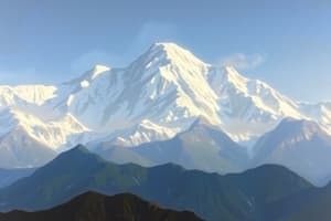
Himalayan Mountains
- Located in the north of India, stretching for over 2,500 km
- Formed as a result of the collision between the Indian and Eurasian tectonic plates
- World's highest and youngest mountain range
- Home to several highest peaks, including:
- Mount Everest (Nepal/India border)
- K2 (India/Pakistan border)
- Annapurna (Nepal)
- Climatically and geologically diverse, with:
- Snow-capped peaks
- Valleys and gorges
- Alpine lakes and glaciers
- Sub-tropical forests
Deccan Plateau
- Larges plateau in India, covering over 1 million km²
- Located in central and southern India
- Formed as a result of volcanic activity and erosion
- Characterized by:
- Gentle slopes and flat tops
- Black soil (regur) suitable for agriculture
- Scarce vegetation, with scattered forests
- Rich mineral deposits, including coal, iron, and manganese
Climate Zones
- India has a diverse range of climate zones, including:
- Tropical (south and west coasts)
- Sub-tropical (Himalayan foothills)
- Temperate (Himalayan Mountains)
- Desert (northwest India)
- Semi-arid (central and western India)
- Climate varies greatly depending on:
- Latitude
- Altitude
- Distance from the sea
- Monsoon patterns
Indus Valley
- Located in northwestern India and eastern Pakistan
- Formed by the Indus River and its tributaries
- One of the earliest urban civilizations, with:
- Mohenjo-Daro and Harappa (Pakistan)
- Lothal and Dholavira (India)
- Known for its advanced irrigation systems and urban planning
River Systems
- India has a vast network of rivers, with:
- Seven major rivers, including the:
- Ganges
- Indus
- Brahmaputra
- Krishna
- Godavari
- Kaveri
- Narmada
- Seven major rivers, including the:
- Rivers play a crucial role in:
- Agriculture and irrigation
- Hydroelectric power generation
- Navigation and transportation
- Cultural and spiritual significance
Himalayan Mountains
- Stretches for over 2,500 km in the north of India
- Formed by the collision of the Indian and Eurasian tectonic plates
- World's highest and youngest mountain range
- Home to several highest peaks, including:
- Mount Everest (Nepal/India border, highest peak)
- K2 (India/Pakistan border, second-highest peak)
- Annapurna (Nepal)
- Features diverse climates and geology, including:
- Snow-capped peaks
- Valleys and gorges
- Alpine lakes and glaciers
- Sub-tropical forests
Deccan Plateau
- Covers over 1 million km² in central and southern India
- Formed by volcanic activity and erosion
- Characterized by:
- Gentle slopes and flat tops
- Black soil (regur) suitable for agriculture
- Scarce vegetation, with scattered forests
- Rich mineral deposits, including coal, iron, and manganese
Climate Zones
- India has a diverse range of climate zones, including:
- Tropical climate in the south and west coasts
- Sub-tropical climate in the Himalayan foothills
- Temperate climate in the Himalayan Mountains
- Desert climate in northwest India
- Semi-arid climate in central and western India
- Climate variation depends on:
- Latitude
- Altitude
- Distance from the sea
- Monsoon patterns
Indus Valley
- Located in northwestern India and eastern Pakistan
- Formed by the Indus River and its tributaries
- Known for its:
- Earliest urban civilizations
- Advanced irrigation systems
- Urban planning
- Notable sites, including:
- Mohenjo-Daro and Harappa (Pakistan)
- Lothal and Dholavira (India)
River Systems
- India has a vast network of rivers, with:
- Seven major rivers, including the:
- Ganges
- Indus
- Brahmaputra
- Krishna
- Godavari
- Kaveri
- Narmada
- Seven major rivers, including the:
- Rivers play a crucial role in:
- Agriculture and irrigation
- Hydroelectric power generation
- Navigation and transportation
- Cultural and spiritual significance
Studying That Suits You
Use AI to generate personalized quizzes and flashcards to suit your learning preferences.