Podcast
Questions and Answers
Which physiographic region in Canada is characterized by its vast expanse of crust and numerous lakes and rivers?
Which physiographic region in Canada is characterized by its vast expanse of crust and numerous lakes and rivers?
- Rocky Mountains
- Interior Plains
- Canadian Shield (correct)
- Great Lakes-St. Lawrence Lowlands
In which region of Canada would you find the highest elevation point at Mount Robson?
In which region of Canada would you find the highest elevation point at Mount Robson?
- Interior Plains (correct)
- Canadian Shield
- Great Lakes-St. Lawrence Lowlands
- Rocky Mountains
Which physiographic region in Canada encompasses the provinces of Newfoundland, New Brunswick, Prince Edward Island, and Nova Scotia?
Which physiographic region in Canada encompasses the provinces of Newfoundland, New Brunswick, Prince Edward Island, and Nova Scotia?
- Arctic Lowlands
- Interior Plains
- Canadian Shield
- Great Lakes-St. Lawrence Lowlands (correct)
What region in Canada shares land borders with the United States to the south and northeast?
What region in Canada shares land borders with the United States to the south and northeast?
Which physiographic region in Canada is located in the top half of the North American continent and stretches from the Atlantic Ocean to the Pacific Ocean?
Which physiographic region in Canada is located in the top half of the North American continent and stretches from the Atlantic Ocean to the Pacific Ocean?
Which physiographic region in Canada is known for its mix of mountains, grasslands, and forests?
Which physiographic region in Canada is known for its mix of mountains, grasslands, and forests?
What is the most significant geographical feature of Canada in terms of providing essential water sources?
What is the most significant geographical feature of Canada in terms of providing essential water sources?
Which physiographic region in Canada is known for its wide-open spaces, dry landscapes, and lack of forests?
Which physiographic region in Canada is known for its wide-open spaces, dry landscapes, and lack of forests?
Where would you find the largest lake in Canada, which is also the world's largest surface freshwater lake?
Where would you find the largest lake in Canada, which is also the world's largest surface freshwater lake?
Which physiographic region in Canada is characterized by a mountainous landscape and the presence of the Appalachian Mountains?
Which physiographic region in Canada is characterized by a mountainous landscape and the presence of the Appalachian Mountains?
What ancient geological formation stretches across the eastern and northern parts of Canada, characterized by its vast expanse of crust and numerous lakes and rivers?
What ancient geological formation stretches across the eastern and northern parts of Canada, characterized by its vast expanse of crust and numerous lakes and rivers?
Which region in Canada is characterized by a series of valleys that have shaped the landscape and contributed to the region's fertile agriculture?
Which region in Canada is characterized by a series of valleys that have shaped the landscape and contributed to the region's fertile agriculture?
Which geographical feature forms a significant portion of the western coast of Canada and is home to some of the country's highest peaks?
Which geographical feature forms a significant portion of the western coast of Canada and is home to some of the country's highest peaks?
In which region of Canada does Mount Everest, the highest point in North America, exist?
In which region of Canada does Mount Everest, the highest point in North America, exist?
Which two languages are the main languages spoken in Canada?
Which two languages are the main languages spoken in Canada?
Which industry has historically been one of the mainstays of Canada's economy?
Which industry has historically been one of the mainstays of Canada's economy?
What is the capital of Canada?
What is the capital of Canada?
Which country is Canada's main trading partner?
Which country is Canada's main trading partner?
What percentage of Canada's GDP do primary industries such as agriculture, fishing, mining, fuel/energy, and logging/forestry make up?
What percentage of Canada's GDP do primary industries such as agriculture, fishing, mining, fuel/energy, and logging/forestry make up?
Flashcards are hidden until you start studying
Study Notes
Geography of Canada
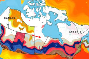
Canada is the second-largest country on Earth, occupying the top half of the North American continent and stretching from the Atlantic Ocean in the east to the Pacific Ocean in the west. It shares land borders with the United States to the south and north-east, and with Alaska to the north-west. The country's unique geography has shaped its landscape, climate, and human settlement patterns.
Physiographic Regions
Canada can be divided into seven physiographic regions:
-
Canadian Shield: This region covers a large portion of the eastern and northern parts of Canada, including the provinces of Ontario, Quebec, and the Yukon. It is characterized by its vast expanse of crust, which dates back billions of years, and the numerous lakes and rivers that have formed over time.
-
Interior Plains: Located in the interior of the country, this region spans across the provinces of British Columbia, Alberta, and Saskatchewan. It features a mix of mountains, grasslands, and forests, with the highest elevation point in Canada being Mount Robson in British Columbia.
-
Great Lakes-St. Lawrence Lowlands: This region encompasses the four Atlantic provinces of Newfoundland, New Brunswick, Prince Edward Island, and Nova Scotia, which are all either wholly or partly coastal. The landscape is shaped by the Atlantic Ocean to the east and the Great Lakes to the west, with many islands and peninsulas separating the mainland from the coast.
-
Appalachian Region: This region covers the eastern seaboard of Canada, stretching from Newfoundland to Maine. It is characterized by a mountainous landscape, with the Appalachian Mountains running along the border between Canada and the United States.
-
Prairies: Central Canada is home to the Prairie provinces of Alberta, Saskatchewan, and Manitoba. This region is known for its wide-open spaces, dry landscapes, and lack of forests, with some of the driest and least-forested parts of the country located here.
Major Geographical Features
Some of the most notable geographical features of Canada include:
-
Lakes: Canada has an estimated three million lakes, covering a significant portion of its land area. The largest lake in the country is Lake Superior, which is also the world's largest surface freshwater lake.
-
Rivers: The country's numerous rivers provide essential water sources for various industries and ecosystems. The Nile River is the longest river system in Canada, stretching approximately 6,300 kilometers.
-
Rocky Mountains: The Rocky Mountains form a significant portion of the western coast of Canada, extending from British Columbia to Alberta. These mountains are home to some of the country's highest peaks, such as Mount Everest, which is the highest point in North America.
-
Canadian Shield: The Canadian Shield is an ancient geological formation that stretches across the eastern and northern parts of Canada. It is characterized by its vast expanse of crust, which dates back billions of years, and the numerous lakes and rivers that have formed over time.
-
Eastern Valleys: The eastern seaboard of Canada is characterized by a series of valleys, such as the St. Lawrence River valley, which has shaped the landscape and contributed to the region's fertile agriculture.
Climate and Vegetation
Canada's large size gives it a wide variety of landscapes, with climates ranging from temperate in the south to positively Arctic in the north. The country has six time zones, and the decision on whether to have daylight savings time is delegated down to the provincial level. Canada's vegetation varies depending on the region, with the coastal areas of the southeast being the most vegetated, while the Prairie provinces have the least forestation.
In summary, Canada's geography is characterized by a diverse range of landscapes, from mountains and valleys to vast expanses of prairie and shield land. Its unique geographical features, such as lakes, rivers, and mountains, have shaped the country's climate, vegetation, and human settlement patterns.
Studying That Suits You
Use AI to generate personalized quizzes and flashcards to suit your learning preferences.