Podcast
Play an AI-generated podcast conversation about this lesson
Download our mobile app to listen on the go
Get App
Questions and Answers
What is the primary purpose of cartography?
What is the primary purpose of cartography?
- To create maps (correct)
- To analyze human interactions with the environment
- To measure distances between two points
- To study the physical characteristics of Earth
Which of the following best describes the concept of causality in geography?
Which of the following best describes the concept of causality in geography?
- The documentation of historical events on a map
- The classification of land use in urban areas
- The exploration of social events associated with geographical phenomena
- The identification of causes that trigger specific phenomena (correct)
Which type of map would best represent physical landforms?
Which type of map would best represent physical landforms?
- Historical map
- Human map
- Physical map (correct)
- Urban map
What function does the equator serve in geographical terms?
What function does the equator serve in geographical terms?
Signup and view all the answers
Which map projection would you use for accurate representation of polar regions?
Which map projection would you use for accurate representation of polar regions?
Signup and view all the answers
Flashcards are hidden until you start studying
Study Notes
Methodological Principles of Geography
- Location: Defined by latitude, longitude, and altitude, providing exact positioning on Earth.
- Causality: Investigates the underlying causes behind geographical phenomena.
- Relation: Examines interactions between geographical events and societal occurrences.
- Generality: Aims to identify patterns and developments of phenomena across space and time.
- Evolution: Focuses on the changes and transformations that geographical events undergo.
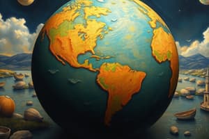
Earth's Axis and Divisions
- Earth’s axis, or pole axis, is an imaginary line connecting the North and South Poles, extending through Earth’s nucleus.
- The Greenwich Meridian (prime meridian) divides the Earth into Eastern and Western hemispheres.
- The equator serves as the horizontal divider of the Earth, establishing the Northern and Southern hemispheres.
- Key parallels include the Tropic of Cancer and Tropic of Capricorn, which mark specific latitudinal lines.
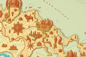
Cartography
- Cartography is the science dedicated to map-making and representation of geographical information.
- Essential elements of a map include a scale, legend, and compass rose for navigation and understanding.
Types of Maps
- Historical Maps: Illustrate human events and their progression over time.
- Human Maps: Represent infrastructure, such as roads, buildings, and networks.
- Physical Maps: Display natural features and physical phenomena of the landscape.
Specialized Maps
- Topographical Maps: Detail terrain relief and variations in landforms.
- Land Use Maps: Illustrate the various usage of land areas.
- Geological Maps: Show the distribution of different geological features.
- Edaphological Maps: Focus on soil properties and types across regions.
- Climatological Maps: Display climate patterns and conditions in various areas.
- Urban Maps: Represent urban development and infrastructure.
Map Projections
- Terrestrial Globe: A three-dimensional representation of Earth’s surface.
- Cylindrical Projection: Maps the globe on a cylinder, distorting shapes at poles.
- Conic Projection: Represents the globe with a cone, often used for mid-latitude regions.
- Azimuthal Projection: Displays the globe from a specific point, useful for polar regions.
- Equidistant Projection: Maintains distances accurately from a central point.
- Mollweide Projection: An equal-area projection representing areas accurately.
- Goode Homolosine Projection: A composite map that reduces distortion in area and shape.
Studying That Suits You
Use AI to generate personalized quizzes and flashcards to suit your learning preferences.