Podcast
Questions and Answers
Haritalar hangi amaçla kullanılır?
Haritalar hangi amaçla kullanılır?
- Tarih boyunca insan coğrafyasını anlamak için (correct)
- Yüzeyin verilerini saklamak için
- Yönleri belirlemek için
- Sadece dağları ve nehirleri göstermek için
Haritalar hangi teknolojiyi kullanarak veri depolar?
Haritalar hangi teknolojiyi kullanarak veri depolar?
- Uzaktan algılama
- GPS
- Radar
- GIS (correct)
Ülkelerin haritalardaki şekilleri ve konumları hakkında neden önemli bilgi ediniriz?
Ülkelerin haritalardaki şekilleri ve konumları hakkında neden önemli bilgi ediniriz?
- Sadece tarihi olayları bilmek için
- Komşu bölgelerle ilişkilerini anlamak için (correct)
- Sadece yön bulmak için
- Coğrafi özellikleri anlamak için
Haritalar hangi zorlukları sunar?
Haritalar hangi zorlukları sunar?
Medieval haritaları incelediğimizde, ne tür bilgiler elde edebiliriz?
Medieval haritaları incelediğimizde, ne tür bilgiler elde edebiliriz?
Haritaların tasarımında hangi unsurlar kullanılarak sorunlar en aza indirgenmeye çalışılır?
Haritaların tasarımında hangi unsurlar kullanılarak sorunlar en aza indirgenmeye çalışılır?
GIS teknolojisi harita yapımında neleri dönüştürmüştür?
GIS teknolojisi harita yapımında neleri dönüştürmüştür?
Haritaların rolü arasında aşağıdaki hangisi doğru bir ifadedir?
Haritaların rolü arasında aşağıdaki hangisi doğru bir ifadedir?
Haritalar hangi konuda hassasiyet sağlayarak temel kaynaklara eşit erişimi destekler?
Haritalar hangi konuda hassasiyet sağlayarak temel kaynaklara eşit erişimi destekler?
'Haritaların dünya hakkındaki hikayeler anlattığı ve bizi geçmiş, şimdi ve geleceğe bağladığı' ifadesi hangi özelliği vurgular?
'Haritaların dünya hakkındaki hikayeler anlattığı ve bizi geçmiş, şimdi ve geleceğe bağladığı' ifadesi hangi özelliği vurgular?
Study Notes
Geography and Maps: Exploring Geographical Features and Countries
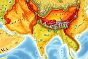
Maps are visual representations of the world, helping us navigate and understand its geographic features and countries. They're more than just directions—they're stories, conveying the history, culture, and beliefs of the people who created them.
Geographical Features
Maps show us everything from mountains and rivers to cities and national parks. They can be thematic, displaying patterns like forest distribution, or topographic, illustrating elevation changes. Cartographers, or mapmakers, use GIS (geographic information systems) technology to capture, store, and display data related to Earth's surface.
Countries
Countries, with their unique borders and histories, are a fundamental part of maps. A country's shape, size, and location are essential in understanding its relationship with neighboring regions and the world at large. Maps help us visualize the complex political landscape of our planet and appreciate the rich tapestry of human geography.
Historical Insights
Maps are not just for the present; they're a window into history. Medieval maps, for example, reveal religious beliefs and cultural perspectives of the time. Even modern maps, like the Upside-Down Map of the World published in New Zealand, showcase unique regional perspectives.
Challenges and Advancements
Representing the world's geography on a flat surface presents challenges, such as distortion and inaccuracies. Cartographers work to minimize these issues by selecting data, applying projections, and designing legends and indexes.
Technology like GIS, GPS, and satellite imagery has revolutionized mapmaking. Today's maps are not only accurate but interactive and dynamic, constantly updated as the world changes.
Maps in Action
Maps play a critical role in guiding explorers, helping conservationists protect ecosystems, and assisting humanitarians in disaster relief. They enable precision in the planning of vaccination campaigns and reveal food desert patterns, supporting equitable access to essential resources.
So, next time you look at a map, remember that it's not just a tool for navigation. It's a beautiful, complex representation of our world, telling stories and connecting us to the past, present, and future.
Studying That Suits You
Use AI to generate personalized quizzes and flashcards to suit your learning preferences.
Description
Explore the significance of maps as visual representations of geographical features, countries, and historical insights. Learn about how maps convey stories, cultures, and the complex political landscape of our planet, while also addressing challenges and advancements in mapmaking technology.