Podcast
Questions and Answers
What distinguishes geographic problems from other types of problems?
What distinguishes geographic problems from other types of problems?
- They are only relevant to urban areas.
- They deal solely with historical data.
- They involve an aspect of location. (correct)
- They only involve financial issues.
Which of the following is NOT a category of geographic problems?
Which of the following is NOT a category of geographic problems?
- Intent
- Climate (correct)
- Scale
- Time scale
What is the primary focus of spatial analysis?
What is the primary focus of spatial analysis?
- Examining relationships in coordinate-based information. (correct)
- Studying cultural phenomena.
- Calculating population demographics.
- Understanding financial trends.
Which of the following describes the term 'spatiotemporal'?
Which of the following describes the term 'spatiotemporal'?
Which component of GIS is most impacted by advances in machine power?
Which component of GIS is most impacted by advances in machine power?
What is the key property of a paper map that is not applicable to digital maps?
What is the key property of a paper map that is not applicable to digital maps?
How are geographic coordinates defined?
How are geographic coordinates defined?
What is a common method of generalization in Geographic Information Systems (GIS)?
What is a common method of generalization in Geographic Information Systems (GIS)?
What does autocorrelation in geographic data mainly allow for?
What does autocorrelation in geographic data mainly allow for?
What defines the importance of the network in GIS?
What defines the importance of the network in GIS?
What aspect of geographic data introduces uncertainty when comparing different samples?
What aspect of geographic data introduces uncertainty when comparing different samples?
What is a common challenge when categorizing geographic problems?
What is a common challenge when categorizing geographic problems?
Which of the following statements regarding digital maps is true?
Which of the following statements regarding digital maps is true?
In the context of geographic data, what does standard error primarily address?
In the context of geographic data, what does standard error primarily address?
What field deals with measuring and quantifying the earth's shape and size?
What field deals with measuring and quantifying the earth's shape and size?
Which property is NOT described as a main source of geographic uncertainty?
Which property is NOT described as a main source of geographic uncertainty?
Which method of spatial interpolation is NOT based on spatial autocorrelation?
Which method of spatial interpolation is NOT based on spatial autocorrelation?
What is the purpose of optimization techniques in geographic studies?
What is the purpose of optimization techniques in geographic studies?
Which measure of central tendency can be applied to ordinal data?
Which measure of central tendency can be applied to ordinal data?
What is the point that minimizes the total straight-line distance known as?
What is the point that minimizes the total straight-line distance known as?
What statistical method is primarily concerned with generalizing results from small studies to larger contexts?
What statistical method is primarily concerned with generalizing results from small studies to larger contexts?
What characteristic does the centroid of a distribution represent?
What characteristic does the centroid of a distribution represent?
Which of the following describes a common use for inverse-distance weighting (IDW)?
Which of the following describes a common use for inverse-distance weighting (IDW)?
What is the primary purpose of orthophotos?
What is the primary purpose of orthophotos?
How many satellites are required for 3D positioning in the user segment of GPS?
How many satellites are required for 3D positioning in the user segment of GPS?
What distinguishes Statistical GPS from other types of GPS?
What distinguishes Statistical GPS from other types of GPS?
What is the average error range for Differential GPS (DGPS)?
What is the average error range for Differential GPS (DGPS)?
What is a characteristic of projections that are conformal?
What is a characteristic of projections that are conformal?
Which navigation system is NOT mentioned as part of the satellite-based systems?
Which navigation system is NOT mentioned as part of the satellite-based systems?
Which term describes a projection that keeps areas intact?
Which term describes a projection that keeps areas intact?
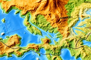
What does the elevation curve show?
What does the elevation curve show?
What describes the relationship of the geodetic datum to the geoid?
What describes the relationship of the geodetic datum to the geoid?
In a Cartesian coordinate system, what terms are commonly used for coordinates?
In a Cartesian coordinate system, what terms are commonly used for coordinates?
Which type of projection is wrapped around the Earth like a cylinder?
Which type of projection is wrapped around the Earth like a cylinder?
Which type of GPS offers the highest level of accuracy?
Which type of GPS offers the highest level of accuracy?
What does a scale-invariant projection prioritize?
What does a scale-invariant projection prioritize?
For which purpose is topography 100 map best utilized?
For which purpose is topography 100 map best utilized?
Which of the following statements about projections is true?
Which of the following statements about projections is true?
What distinguishes first-order processes from second-order processes?
What distinguishes first-order processes from second-order processes?
Which statistic is used to measure the patchiness of data sets, such as vegetation cover?
Which statistic is used to measure the patchiness of data sets, such as vegetation cover?
In optimizing point locations using GIS, what is a common goal?
In optimizing point locations using GIS, what is a common goal?
What type of interactions may lead to clustering in second-order processes?
What type of interactions may lead to clustering in second-order processes?
Which method is implemented to support decision making in optimizing designs?
Which method is implemented to support decision making in optimizing designs?
What is indicated by the size distribution of patches in a histogram of patch size?
What is indicated by the size distribution of patches in a histogram of patch size?
What is a key component of finding optimum paths in GIS?
What is a key component of finding optimum paths in GIS?
Flashcards
Geographic Problems
Geographic Problems
Problems involving location, whether in the data or the solution.
Scale (in geography)
Scale (in geography)
Level of detail (zoom level) in geographic data.
Intent (in geography)
Intent (in geography)
Purpose of geographic analysis, like conservation or resource use.
Time Scale (in geography)
Time Scale (in geography)
Signup and view all the flashcards
Geographic Coordinates
Geographic Coordinates
Signup and view all the flashcards
Spatial
Spatial
Signup and view all the flashcards
Spatiotemporal
Spatiotemporal
Signup and view all the flashcards
GIS
GIS
Signup and view all the flashcards
Field Compression
Field Compression
Signup and view all the flashcards
Digital Scale
Digital Scale
Signup and view all the flashcards
Generalization
Generalization
Signup and view all the flashcards
Weeding
Weeding
Signup and view all the flashcards
Geographic Uncertainty
Geographic Uncertainty
Signup and view all the flashcards
Autocorrelation
Autocorrelation
Signup and view all the flashcards
Geodesy
Geodesy
Signup and view all the flashcards
Continental Drifts
Continental Drifts
Signup and view all the flashcards
Geodetic Datum
Geodetic Datum
Signup and view all the flashcards
Ellipsoid
Ellipsoid
Signup and view all the flashcards
Cartesian Coordinate System
Cartesian Coordinate System
Signup and view all the flashcards
Map Projection
Map Projection
Signup and view all the flashcards
Conformal Projection
Conformal Projection
Signup and view all the flashcards
Equal-Area Projection
Equal-Area Projection
Signup and view all the flashcards
Cylindrical Projection
Cylindrical Projection
Signup and view all the flashcards
Orthophoto
Orthophoto
Signup and view all the flashcards
Landcover
Landcover
Signup and view all the flashcards
Elevation Curve
Elevation Curve
Signup and view all the flashcards
What are the 3 main GPS systems?
What are the 3 main GPS systems?
Signup and view all the flashcards
Control Segment (GPS)
Control Segment (GPS)
Signup and view all the flashcards
User Segment (GPS)
User Segment (GPS)
Signup and view all the flashcards
What's the difference between Absolute and Differential GPS?
What's the difference between Absolute and Differential GPS?
Signup and view all the flashcards
What is Network RTK GPS?
What is Network RTK GPS?
Signup and view all the flashcards
Thiessen Polygons
Thiessen Polygons
Signup and view all the flashcards
Inverse-Distance Weighting (IDW)
Inverse-Distance Weighting (IDW)
Signup and view all the flashcards
Kriging
Kriging
Signup and view all the flashcards
Spatial Autocorrelation
Spatial Autocorrelation
Signup and view all the flashcards
Mean
Mean
Signup and view all the flashcards
Median
Median
Signup and view all the flashcards
Mode
Mode
Signup and view all the flashcards
Centroid
Centroid
Signup and view all the flashcards
First-order process
First-order process
Signup and view all the flashcards
Second-order process
Second-order process
Signup and view all the flashcards
K Function
K Function
Signup and view all the flashcards
Fragmentation Statistics
Fragmentation Statistics
Signup and view all the flashcards
Optimization in GIS
Optimization in GIS
Signup and view all the flashcards
Optimizing Point Locations
Optimizing Point Locations
Signup and view all the flashcards
Optimum Paths
Optimum Paths
Signup and view all the flashcards
Spatial-Decision Support Systems (SDSS)
Spatial-Decision Support Systems (SDSS)
Signup and view all the flashcards
Study Notes
Geographic Problems (Lecture 1)
- Geographic problems involve location in the information or solutions
- Examples include forest management (cutting, replanting, roads), national park accessibility, and fertilizer application in farming.
- Three categories of geographic problems exist:
- Scale (detail): Micro, Local (cities, parks), Regional (regions, epidemics), Global (global warming, pandemics).
- Intent (purpose): Practical (urgent needs, money, emergencies), Curiosity-driven (less urgent, exploring phenomena).
- Time Scale: Operational (efficiency), Tactical (short-term plans), Strategic (long-term goals).
Geographic Coordinates
- Geographic refers to Earth's coordinates (or any planetary system).
- Spatial refers to any coordinate system, including statistical data with spatial dimensions.
- Earth's system is a subset of generic space.
- Spatial coordinates are special as they include:
- Dimensions (defining location).
- Resolution (detail level).
- Coordinate Systems (representing).
- Topology (direction, distance, size).
- Spatial analysis involves all coordinate-related information.
Spatiotemporal
- Spatial progress in time (or vice versa).
- Temporal progress is often captured by comparing spatial snapshots taken along a timeline.
The Anatomy of GIS
- Hardware (increasing machine power; 2D, 3D, 4D limitations).
- Software (runs locally).
- Network (important for information spread).
- Data (digital representation of specified area aspects).
Geographic Attributes
- Nominal: No ranking, no equidistance, no absolute zero (e.g., county).
- Ordinal: Ranking, non-equidistant, no absolute zero (e.g., grades).
- Interval: Ranking, equidistant, no absolute zero (e.g., temperature).
- Ratio: Ranking, equidistant, absolute zero (e.g., concentrations).
- Cyclic: Ranking, equidistance, absolute zero (e.g., compass, Kelvin).
Geographic Data Representation (L2)
- Representations are digital models of Earth's surface aspects
- Simplification is vital for computer processing.
- Spatial averaging (pixels with varying density).
- Representing constant values over large areas.
Raster and Vector
- Raster: Divides the world into cells, each with an attribute value (e.g., satellite images).
- Raster cells are squares generally that fit onto a surface, but distortion occurs when projected on Earth's curved surface.
- Cells store a single attribute value, making them good for representing phenomena and statistical modeling. Raster representations are better suited for geographical models than vector representations.
- Vector: Curves are captured as points (vertices) connected by straight lines (common in geographic information systems).
- Vectors are effective for precise representation, including direction, distance, and ranking.
- Raster files (e.g., TIFF, JPG) and vector files (e.g., shapefiles, geodatabases) are used.
GIS Applications
- Mapping, Measurement, Monitoring, Modeling, Management. Maps cover a wide range of applications in the area of socioeconomic and environmental modeling, base mapping, and education. Examples of different GIS applications include but are not limited to the following.
Geodesy (L3)
- Geodesy studies Earth's shape, size, how to measure Earth's rotation and gravity, and continental drifts.
- A geoid is a model of a global average sea level that is perpendicular to gravity.
- An ellipsoid is a mathematical model of Earth, slightly flattened.
- Coordinates (longitude and latitude) are used to specify locations on Earth.
Projections
- Projections convert spherical Earth data onto a flat surface.
- Distortions are inherent in projections. Types include cylindrical (normal, transverse), Conic (tangential), and Azimuthal (tangential). Types of projection include Secant and tangent projections to minimize distortion.
- UTM is a widely used transverse Mercator projection.
- Local coordinate systems (e.g., Swedish Triangulated Grid, RT90) are used for specific regions.
Converting Geo-references
- GIS applications often involve converting projections and ellipsoids.
- Street addresses and place names can be converted to coordinates (geocoding).
Satellite-based Navigation and Positioning (L5)
- GPS (Global Positioning System), Glonass, Galileo
- Satellites orbit Earth, sending signals to receivers.
- GPS data types: Absolute (low precision), Differential, Statistical, and Network.
Equipment, Accuracy, and Cost
- Various equipment options (e.g., GPS receivers) exist to determine accuracy, cost, and overall performance.
Electromagnetic Spectrum
- Data are collected from the reflection in different wavelength bands
- Wavelengths are described from high frequency, high energy, and short wavelengths (Gamma, X-ray, to low frequency, low energy, and long wavelengths (radio waves).
Spectral Reflectance
- Reflectance of light across different wavelength bands.
Remote Sensing
- Multispectral use wavelengths (various colors) of light.
- Collects data in various bands, resulting in a summary of the reflection levels of different wavelengths.
The Visible Spectrum
- Visual light that we can see using photogrammetry technology.
- Different wavelengths are used for various data, including identifying vegetation, landcover, and infrastructure.
Cartography and Map Production (L6)
- Cartography is the art, science, and technique of making maps and charts. Formal maps: Reference maps (topographic) and thematic maps. Categorical/Map Production: Provides a useful tool for different types of maps for a variety of purposes.
Spatial Analysis
- Spatial analysis processes raw data into useful information (e.g., discovering patterns).
- Methods include queries, measurements, transformations, descriptive summaries, optimization, and hypothesis testing.
Spatial Interpolation
- A process of intelligent guesswork to estimate values of a continuous field where no measurements have been taken. common interpolation methods are thiessen polygons, inverse-distance weighting (IDW) and kriging.
- Inverse Distance Weighting and Kriging methods.
Studying That Suits You
Use AI to generate personalized quizzes and flashcards to suit your learning preferences.