Podcast
Questions and Answers
More faults lead to more ______, as cracks weaken rock for weathering.
More faults lead to more ______, as cracks weaken rock for weathering.
erosion
Dips in the rock refer to the angle of inclination of ______, affecting cliff profiles.
Dips in the rock refer to the angle of inclination of ______, affecting cliff profiles.
bedding planes
Landward facing bedding planes produce stable cliffs that minimize ______ erosion.
Landward facing bedding planes produce stable cliffs that minimize ______ erosion.
marine
Hydraulic action is the sheer force of ______ entering cracks in rocks.
Hydraulic action is the sheer force of ______ entering cracks in rocks.
The Holderness coastline experiences 2m/yr of erosion due to long ______ of high energy waves.
The Holderness coastline experiences 2m/yr of erosion due to long ______ of high energy waves.
Freeze thaw in high latitudes weakens rock, increasing susceptibility to ______ movement.
Freeze thaw in high latitudes weakens rock, increasing susceptibility to ______ movement.
Carbonation weathering occurs when rainfall combines with ______ in the atmosphere.
Carbonation weathering occurs when rainfall combines with ______ in the atmosphere.
In Kaikoura Peninsula, NZ, high energy waves break before hitting the coastal ______.
In Kaikoura Peninsula, NZ, high energy waves break before hitting the coastal ______.
Sand beaches are wider as particles are easily distributed due to less friction from smooth ______, compared to shingle.
Sand beaches are wider as particles are easily distributed due to less friction from smooth ______, compared to shingle.
In winter, rougher conditions with stronger winds may cause more severe storms, causing destructive waves with a weak ______ and strong backwash.
In winter, rougher conditions with stronger winds may cause more severe storms, causing destructive waves with a weak ______ and strong backwash.
In winter, material eroded is deposited in the form of offshore ______.
In winter, material eroded is deposited in the form of offshore ______.
The process of cracks widening at the base of the headland within the intertidal zone is caused by hydraulic action and __________.
The process of cracks widening at the base of the headland within the intertidal zone is caused by hydraulic action and __________.
During summer, calmer conditions lead to constructive waves that build material back up the beach, creating a ______ and less steep beach.
During summer, calmer conditions lead to constructive waves that build material back up the beach, creating a ______ and less steep beach.
As cracks widen further, they eventually form __________ cut notches.
As cracks widen further, they eventually form __________ cut notches.
Once two caves align, they can form an __________.
Once two caves align, they can form an __________.
Berms are a marker of the highest ______.
Berms are a marker of the highest ______.
Storms and spring tides can move existing ______ up the beach, which changes the beach profile.
Storms and spring tides can move existing ______ up the beach, which changes the beach profile.
The roof of an arch eventually becomes unstable and __________, leaving a stack.
The roof of an arch eventually becomes unstable and __________, leaving a stack.
A __________ is a steep-sided inlet formed where a joint is eroded.
A __________ is a steep-sided inlet formed where a joint is eroded.
The offshore gradient is less steep in winter due to erosion and material movement, whereas it becomes more ______ in summer.
The offshore gradient is less steep in winter due to erosion and material movement, whereas it becomes more ______ in summer.
At Duncansby Head, less resistant __________ along faults erodes quicker, forming geos.
At Duncansby Head, less resistant __________ along faults erodes quicker, forming geos.
Each zone of the beach contains its own small-scale ______ features.
Each zone of the beach contains its own small-scale ______ features.
The __________ coastline features alternating bands of clay, sands, chalk, and limestone.
The __________ coastline features alternating bands of clay, sands, chalk, and limestone.
Durdle Door is an example of a natural __________ formed from Portland limestone.
Durdle Door is an example of a natural __________ formed from Portland limestone.
A __________ profile is a cross-section of the beach extending from the sea to the base of the cliff.
A __________ profile is a cross-section of the beach extending from the sea to the base of the cliff.
Lulworth Cove is an example of a __________ formed from Portland limestone.
Lulworth Cove is an example of a __________ formed from Portland limestone.
Swash-aligned coasts feature larger beach profiles (more cliff), cusps, riffles, ridges & runnels, and sand ______.
Swash-aligned coasts feature larger beach profiles (more cliff), cusps, riffles, ridges & runnels, and sand ______.
Drift-aligned coasts are controlled by longshore ______.
Drift-aligned coasts are controlled by longshore ______.
The distal end of the spit is exposed to a change in wind direction, forming a ______ end.
The distal end of the spit is exposed to a change in wind direction, forming a ______ end.
A sheltered area behind a spit is protected by waves of sea, so material accumulates, forming a salt ______.
A sheltered area behind a spit is protected by waves of sea, so material accumulates, forming a salt ______.
Swash-aligned coasts are oriented ______ to wave energy.
Swash-aligned coasts are oriented ______ to wave energy.
A well defined sequence of dune ridges develops - each with its own distinctive size and plant ______.
A well defined sequence of dune ridges develops - each with its own distinctive size and plant ______.
Plant succession stabilises ______, which is vital for dune formation.
Plant succession stabilises ______, which is vital for dune formation.
Plant succession in sand dunes is an example of ______ succession.
Plant succession in sand dunes is an example of ______ succession.
A psammosere refers to the plant succession of a sand ______.
A psammosere refers to the plant succession of a sand ______.
Cuspate forelands are low lying triangular shaped ______, formed from deposited sediment.
Cuspate forelands are low lying triangular shaped ______, formed from deposited sediment.
Overall trends show more stability by vegetation away from the ______.
Overall trends show more stability by vegetation away from the ______.
Barrier beaches are linear ridges of sand/shingle extending across a ______.
Barrier beaches are linear ridges of sand/shingle extending across a ______.
When wave energy is insufficient, large ______ are deposited at the boundary of offshore/nearshore zones.
When wave energy is insufficient, large ______ are deposited at the boundary of offshore/nearshore zones.
Lower pH away from beach occurs because of a lower percentage of calcium ______.
Lower pH away from beach occurs because of a lower percentage of calcium ______.
More organic matter and humus away from the beach is caused by death of ______ species.
More organic matter and humus away from the beach is caused by death of ______ species.
An example of a barrier beach is ______, which forms as a spit across the width of a bay.
An example of a barrier beach is ______, which forms as a spit across the width of a bay.
A strand line forms as tide goes out and sand is dried and blown up the ______.
A strand line forms as tide goes out and sand is dried and blown up the ______.
At Dungeness, Kent, the triangular extension of coastline is due to the interaction of the main W-E longshore drift with the N-S ______.
At Dungeness, Kent, the triangular extension of coastline is due to the interaction of the main W-E longshore drift with the N-S ______.
As sea levels rise, the former dunes can become ______, forming new coastal islands.
As sea levels rise, the former dunes can become ______, forming new coastal islands.
Lagoons are formed behind barrier beaches when they trap a body of ______.
Lagoons are formed behind barrier beaches when they trap a body of ______.
Beach ridge formation is theorized to begin when sea level was 100m ______ than it is now.
Beach ridge formation is theorized to begin when sea level was 100m ______ than it is now.
Flashcards
Fault Erosion
Fault Erosion
More faults lead to more erosion, as faults create cracks weakening the rock, making it more susceptible to weathering and erosion.
Dip Angle
Dip Angle
The angle of inclination of bedding planes (layers) in rock, significantly affecting cliff formations.
Hydraulic Action
Hydraulic Action
The forceful power of waves entering cracks in rocks, exerting pressure and breaking off pieces of the rock.
Cavitation
Cavitation
Signup and view all the flashcards
Sub-Aerial Processes
Sub-Aerial Processes
Signup and view all the flashcards
Freeze-Thaw Weathering
Freeze-Thaw Weathering
Signup and view all the flashcards
Carbonation Weathering
Carbonation Weathering
Signup and view all the flashcards
Mass Movement
Mass Movement
Signup and view all the flashcards
Cliff erosion
Cliff erosion
Signup and view all the flashcards
Wave-cut notch
Wave-cut notch
Signup and view all the flashcards
Cave formation
Cave formation
Signup and view all the flashcards
Arch formation
Arch formation
Signup and view all the flashcards
Stack formation
Stack formation
Signup and view all the flashcards
Stump formation
Stump formation
Signup and view all the flashcards
Geo
Geo
Signup and view all the flashcards
Discordant coastline
Discordant coastline
Signup and view all the flashcards
Concordant coastline
Concordant coastline
Signup and view all the flashcards
Beach Profile
Beach Profile
Signup and view all the flashcards
Winter Beach Profile
Winter Beach Profile
Signup and view all the flashcards
Summer Beach Profile
Summer Beach Profile
Signup and view all the flashcards
Destructive Waves
Destructive Waves
Signup and view all the flashcards
Constructive Waves
Constructive Waves
Signup and view all the flashcards
Offshore Bars
Offshore Bars
Signup and view all the flashcards
Berms
Berms
Signup and view all the flashcards
Storm Beaches
Storm Beaches
Signup and view all the flashcards
Beach Profile Changes
Beach Profile Changes
Signup and view all the flashcards
Swash-aligned coast
Swash-aligned coast
Signup and view all the flashcards
Drift-aligned coast
Drift-aligned coast
Signup and view all the flashcards
Simple Spit
Simple Spit
Signup and view all the flashcards
Longshore drift
Longshore drift
Signup and view all the flashcards
Recurved end of a Spit
Recurved end of a Spit
Signup and view all the flashcards
Plant Succession
Plant Succession
Signup and view all the flashcards
Primary Succession
Primary Succession
Signup and view all the flashcards
Psammosere
Psammosere
Signup and view all the flashcards
Strand Line
Strand Line
Signup and view all the flashcards
Aeolian Transport
Aeolian Transport
Signup and view all the flashcards
Dune Formation
Dune Formation
Signup and view all the flashcards
Soil Stability
Soil Stability
Signup and view all the flashcards
Soil Characteristics changes
Soil Characteristics changes
Signup and view all the flashcards
Cuspate Foreland
Cuspate Foreland
Signup and view all the flashcards
Barrier Beach
Barrier Beach
Signup and view all the flashcards
Longshore Drift
Longshore Drift
Signup and view all the flashcards
Lagoon
Lagoon
Signup and view all the flashcards
Beach Ridge Formation
Beach Ridge Formation
Signup and view all the flashcards
Barrier Island
Barrier Island
Signup and view all the flashcards
Sediment Deposition (Coastal)
Sediment Deposition (Coastal)
Signup and view all the flashcards
Spit
Spit
Signup and view all the flashcards
Study Notes
Coastal Environments
- Coastal processes involve wave generation (fetch, energy, refraction, breaking waves, swash, backwash), marine erosion (hydraulic action, cavitation, corrasion, solution, attrition), sub-aerial processes (weathering, mass movement), and marine transportation/deposition (sediment sources, characteristics, sediment cells, longshore drift).
Coastal Landforms
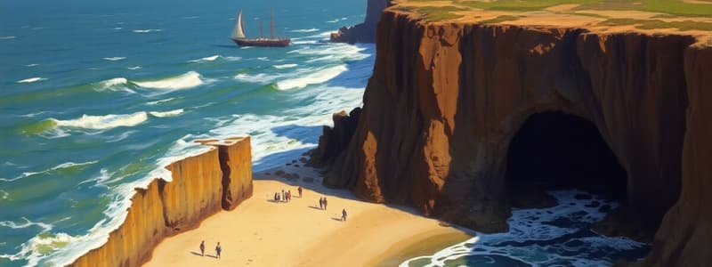
- Erosional landforms include cliffs, wave-cut platforms, caves, arches, stacks.
- Depositional landforms include beaches (cross-section/plan, swash and drift-aligned beaches), spits (simple and compound), tombolos, offshore bars, barrier beaches, coastal dunes, tidal sedimentation in estuaries, coastal salt marshes, and mangroves.
- Sea level change plays a critical role in coastal landform formation.
Coral Reefs
- Coral reefs are characterized by their structure, distribution, and method of formation.
- Types include fringing reefs, barrier reefs, and atolls.
- Coral growth is influenced by specific environmental conditions.
- Conservation and management strategies are important for coral reefs, particularly given threats like global warming, sea-level rise, pollution, and physical damage.
Sustainable Management of Coasts
- Coastal management involves analyzing the problems and evaluating the effectiveness of management strategies to protect coastlines.
- Case studies are a significant component of assessing coastal management solutions.
- Case studies encompass both hard and soft engineering approaches.
Erosional Landforms
- Cliffs and wave-cut platforms form due to wave energy eroding the base of a cliff, leading to overhang collapse and cliff retreat.
- Cliff heights increase through rock type erosion rates, and wave action.
- Wave-cut platforms are flat areas extending from the cliff.
- Rock type and structure (resistant vs less resistant) affect cliff formation.
- Composite cliffs consist of multiple rock types, leading to differential erosion rates.
- Faults in rock decrease rock resistance, leading to more rapid erosion.
- Dips (inclination of bedding planes) affect cliff profiles.
- Marine processes (hydraulic action and cavitation) affect cliff material removal (breaking apart).
- Sub-aerial processes like freeze-thaw weathering further weaken rock.
Development of Cliffs and Wave-Cut Platforms
- Wave energy erodes the base of cliffs, creating wave-cut notches.
- The unsupported weight of cliffs leads to overhang collapse, causing them to retreat.
- Cliffs made of hard rock (e.g. chalk) result in steep cliffs.
- Wave-cut platforms form by the horizontal erosion of the cliff base.
- Cliff erosion continues until the wave-cut platform extends to a point where water no longer reaches the cliff base.
Coastal Landforms: Depositional Section
- Beaches: The zone of loose sediment between the mean low tide line and where the material/physiographic form changes.
- Beach profiles are cross-sectional views from the sea to the cliff base.
- A beach is characterized by 5 zones (onshore, backshore, foreshore, nearshore, offshore).
- Beach profiles are affected by factors such as tidal range, and type/amount of sediment. Wide beaches are related to smooth sand; narrower beaches to shingle.
- Beach profiles are affected by seasonal changes: Winter (steeper beach gradient, less steep offshore gradient) and Summer (less steep beach gradient, steeper offshore gradient).
- Sand Dunes: Small ridges of sand found above the maximum reach of waves. Conditions needed for dune development include sand availability, dry sand, large tidal range, and large flat areas with obstructions. Types of Aeolian transport (creep, saltation, suspension) are important components of dune development. Plant succession is crucial to dune development; the sequence of vegetation changes based on plant tolerances to increasingly dry/nutrient-poor conditions.
- Barrier Beaches/Barrier Islands/Bars: Linear ridges of sand/shingle across a bay, connected to land on both sides. They form from longshore drift, create lagoons, and can be caused by rising sea levels.
- Spits: Narrow stretches of sand extending into the sea from land, sometimes attaching to other pieces of land or islands. Prevailing winds will influence their shape and development.
- Tombolos: Ridge or sand attaching an offshore island to mainland areas.
- Offshore Bars: Ridges located offshore that are often made of sand or shingle.
- Cuspate Forelands: Low-lying triangular headlands formed from coastal sediments when longshore currents converge on the shoreline. They are influenced by opposing currents.
- Salt Marshes and Mudflats: Coastal wetlands that are regularly flooded by tides, contain grasses and herbs, and are found on low-energy coastlines, behind spits or barrier islands. Mudflats often are sediment deposits in fluid medium from rivers.
Role of Sea Level Change
- Eustatic Change: Global changes in sea level, related to temperature (melting ice and thermal expansion).
- Isostatic Change: Local changes in land elevation (uplift or subsidence), often due to glaciation.
- Eustatic and isostatic changes profoundly impact coastal landform formation and evolution. Rising sea levels result in coastal submergence (flooded valleys or fjords) and, with falling sea levels, coastal emergence (raised beaches with relict features).
Studying That Suits You
Use AI to generate personalized quizzes and flashcards to suit your learning preferences.


