Podcast
Questions and Answers
What is the main distinction of cumulonimbus clouds compared to other cloud types?
What is the main distinction of cumulonimbus clouds compared to other cloud types?
Cumulonimbus clouds are unique because they can produce hail, thunder, and lightning.
Why do clouds generally appear white?
Why do clouds generally appear white?
Clouds appear white because larger water droplets scatter sunlight almost equally across all colors, preserving its white appearance.
What causes cloud bases to appear grey, especially in rain clouds?
What causes cloud bases to appear grey, especially in rain clouds?
Cloud bases appear grey because they receive less sunlight due to larger droplets scattering light more strongly upwards and outwards.
What is the typical height range for the base of cumulonimbus clouds?
What is the typical height range for the base of cumulonimbus clouds?
How does the size of water droplets in clouds affect their color and appearance?
How does the size of water droplets in clouds affect their color and appearance?
What criteria are used to categorize clouds?
What criteria are used to categorize clouds?
Which types of clouds are capable of producing precipitation?
Which types of clouds are capable of producing precipitation?
What does an okta measure in relation to cloud cover?
What does an okta measure in relation to cloud cover?
What prefix is used for high-level clouds and what is their common composition?
What prefix is used for high-level clouds and what is their common composition?
Describe the appearance and characteristics of cirrus clouds.
Describe the appearance and characteristics of cirrus clouds.
How do cirrostratus clouds differ from cirrus clouds?
How do cirrostratus clouds differ from cirrus clouds?
What are the two main features indicated by the prefix 'nimbo-' in cloud classification?
What are the two main features indicated by the prefix 'nimbo-' in cloud classification?
Explain the significance of cumulonimbus clouds in weather prediction.
Explain the significance of cumulonimbus clouds in weather prediction.
What two main types of mid-level clouds are identified in the content?
What two main types of mid-level clouds are identified in the content?
How do altostratus clouds typically behave when warm air approaches?
How do altostratus clouds typically behave when warm air approaches?
What is the primary characteristic of low-level clouds?
What is the primary characteristic of low-level clouds?
What type of cloud is characterized by a uniform and flat texture?
What type of cloud is characterized by a uniform and flat texture?
What are stratocumulus clouds considered to be a hybrid of?
What are stratocumulus clouds considered to be a hybrid of?
At what height do altostratus and altocumulus clouds typically form?
At what height do altostratus and altocumulus clouds typically form?
What type of precipitation can nimbostratus clouds produce?
What type of precipitation can nimbostratus clouds produce?
What unique alignment can altocumulus clouds exhibit in the sky?
What unique alignment can altocumulus clouds exhibit in the sky?
Flashcards
Cloud Classification
Cloud Classification
Clouds are categorized based on their altitude (high, middle, low) and shape (cirro, alto, strato, nimbo, cumulo).
High-Level Clouds
High-Level Clouds
High-level clouds are found above 20,000 feet (6 km) and consist mainly of ice crystals. They often appear thin, wispy, and white.
Cirrus Clouds
Cirrus Clouds
Cirrus clouds are wispy, feathery clouds composed entirely of ice crystals. They are often associated with fair weather.
Cirrostratus Clouds
Cirrostratus Clouds
Signup and view all the flashcards
Cirrocumulus Clouds
Cirrocumulus Clouds
Signup and view all the flashcards
Stratus Clouds
Stratus Clouds
Signup and view all the flashcards
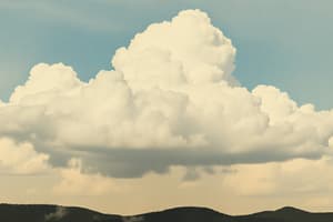
Cumulonimbus Clouds
Cumulonimbus Clouds
Signup and view all the flashcards
Cloud Cover
Cloud Cover
Signup and view all the flashcards
Why are Clouds White?
Why are Clouds White?
Signup and view all the flashcards
Why are Clouds Sometimes Grey?
Why are Clouds Sometimes Grey?
Signup and view all the flashcards
What is the 'Wall-like' Feature Below a Cumulonimbus Cloud?
What is the 'Wall-like' Feature Below a Cumulonimbus Cloud?
Signup and view all the flashcards
What is the Typical Height of a Cumulonimbus Cloud Base?
What is the Typical Height of a Cumulonimbus Cloud Base?
Signup and view all the flashcards
What are Altostratus clouds?
What are Altostratus clouds?
Signup and view all the flashcards
What are Altocumulus clouds?
What are Altocumulus clouds?
Signup and view all the flashcards
What are Stratus clouds?
What are Stratus clouds?
Signup and view all the flashcards
What are Stratocumulus clouds?
What are Stratocumulus clouds?
Signup and view all the flashcards
What are Nimbostratus clouds?
What are Nimbostratus clouds?
Signup and view all the flashcards
What are low-level clouds comprised of during cold winter storms?
What are low-level clouds comprised of during cold winter storms?
Signup and view all the flashcards
What are low-level clouds usually comprised of?
What are low-level clouds usually comprised of?
Signup and view all the flashcards
What texture do Altostratus clouds have?
What texture do Altostratus clouds have?
Signup and view all the flashcards
Study Notes
Clouds
- Clouds are large collections of tiny water droplets or ice crystals.
- These droplets are small and light enough to float in the air.
- All air contains water vapor (an invisible gas).
- Water vapor condenses onto tiny dust particles in the air, creating tiny droplets.
- Warm air rises, expands, and cools.
- Cooling air can't hold as much water vapor as warm air, so some of the water vapor condenses into tiny droplets around dust particles.
- Billions of these droplets clump together to form a visible cloud.
- Clouds are categorized by height and shape.
- Latin words are used to name cloud types (e.g., nimbus clouds bring rain).
- Clouds only create precipitation if water or ice particles collide and join to become too large to stay suspended.
- Cumulonimbus and stratus clouds are the only types capable of producing precipitation.
- Cloud cover is measured in oktas (eighths of the sky covered).
- 0 oktas = clear sky. 8 oktas = completely covered.
- Cloud cover is a key weather element.
Cloud Formation
- Warm air rises, expands and cools.
- The cooling air can hold less water vapor
- Water vapor condenses onto tiny particles in the air (condensation).
- These droplets cluster together forming a visible cloud.
- Clouds are often white because sunlight is scattered by water droplets.
- Clouds can be gray when more light is scattered, so less light reaches the cloud's bottom.
Types of Clouds
- Clouds are classified by height and appearance/shape.
- High clouds are called cirrus (wispy, feathery, ice crystals)
- High clouds are called cirrostratus (thin, sheet-like layer, ice crystals)
- High clouds are called cirrocumulus (small, white patches, ice crystals)
- Medium clouds are called altostratus (thin, gray sheet, water droplets and ice crystals)
- Medium clouds are called altocumulus (white layers or patches, water droplets)
- Low clouds are called stratus (uniform, gray sheet, water droplets)
- Low clouds are called stratocumulus (layered and patchy, water droplets).
- Low clouds are called cumulus (puffy, heaped, often white, water droplets)
- Cumulonimbus (large, dense, often producing heavy rain, thunder, ice crystals) are associated with severe weather.
Cloud Levels
- High-level clouds form above 20,000 feet (6 km).
- Middle-level clouds form between 6,500 and 20,000 feet (2 km to 6 km).
- Low-level clouds form below 6,500 feet (2 km).
Cloud Classification System
- Cirro-: curl of hair, high level
- Alto-: mid level
- Strato-: layer
- Nimbo-: rain, precipitation
- Cumulo-: heap
Studying That Suits You
Use AI to generate personalized quizzes and flashcards to suit your learning preferences.