Podcast
Questions and Answers
What was the area stretching from Alberta to Manitoba covered by 500 million years ago?
What was the area stretching from Alberta to Manitoba covered by 500 million years ago?
- A vast patchwork of inland seas (correct)
- Sweeping grasslands
- The Canadian Shield
- Vast forests
What is the landscape like in the southern regions of the area described?
What is the landscape like in the southern regions of the area described?
- Large, sweeping grasslands (correct)
- Scruby, low-level tree and bush growth
- Vast forests and lakes
- Mountainous
What is the Canadian Shield also known as?
What is the Canadian Shield also known as?
- The Precambrian Shield (correct)
- The Rocky Mountains
- The Canadian Arctic Archipelago
- The Great Lakes
What covers the rugged Canadian Shield where it is not immediately visible?
What covers the rugged Canadian Shield where it is not immediately visible?
What is the majority of the Canadian Arctic composed of?
What is the majority of the Canadian Arctic composed of?
What is a significant effect of global warming in the Canadian Arctic?
What is a significant effect of global warming in the Canadian Arctic?
What is the significance of the Great Lakes in shaping Canada's weather?
What is the significance of the Great Lakes in shaping Canada's weather?
What is the St.Lawrence River's significance in Canada?
What is the St.Lawrence River's significance in Canada?
What is the Canadian Cordillera?
What is the Canadian Cordillera?
What created the mountains of the Cordillera?
What created the mountains of the Cordillera?
What is a characteristic of the ecosystem in the Cordillera?
What is a characteristic of the ecosystem in the Cordillera?
What is the result of the Cordillera on the Canadian plains?
What is the result of the Cordillera on the Canadian plains?
What is the relation between the Canadian Rocky Mountains and the Rocky Mountains in the United States?
What is the relation between the Canadian Rocky Mountains and the Rocky Mountains in the United States?
What is a distinctive feature of the Canadian landscape?
What is a distinctive feature of the Canadian landscape?
What is the location of the Canadian Cordillera?
What is the location of the Canadian Cordillera?
Flashcards are hidden until you start studying
Study Notes
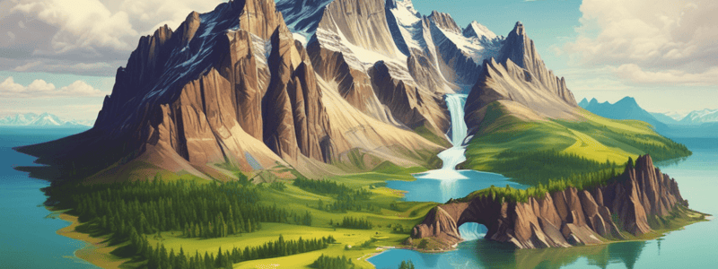
Cordillera and Plains
- The Canadian Cordillera is a unique geographical area extending from the Canadian border to the Arctic Sea in the Yukon.
- The Cordillera was created millions of years ago when the North American plate and the Pacific plate collided.
- The mountains and valleys of the Cordillera create a diverse ecosystem with varying flora, fauna, and temperatures.
- The Cordillera blocked rainstorms, resulting in the Canadian plains receiving less rain.
- The plains were once covered by inland seas that deposited rich sediment, supporting plant life in the area.
- The southern plains have sweeping grasslands, while the northern regions have scrubby, low-level tree and bush growth.
Canadian Shield and Arctic
- The Canadian Shield, also known as the Precambrian Shield, covers nearly half of Canada.
- The shield stretches from north of the Arctic Circle to the U.S. border and the lowlands of Atlantic Canada.
- The Canadian Shield is the world's oldest exposed bedrock, with rugged terrain covered by vast forests, lakes, and ponds.
- The Canadian Arctic is broken up into a large island archipelago, including Ellesmere Island, Baffin Island, and hundreds of others.
- The arctic islands remain frozen for almost the entire year, with a short arctic summer and limited growth.
- The effects of global warming are drastically felt in the arctic, where ice accumulation has decreased and passages between islands are becoming navigable.
Great Lakes and the St. Lawrence
- Four of the five Great Lakes reside half in Canada and half in the United States.
- The Great Lakes shape Canada's weather, with prevailing winds causing lake effect snowfall in the winter.
- Sault Ste. Marie, Ontario, averages over 126 inches of snowfall each year due to lake effect snow.
- The Great Lakes empty into the St. Lawrence River, which conducts fresh water through eastern Canada to the Atlantic Ocean.
- The Great Lakes and the St. Lawrence affect millions of Canadians, with Canada's two largest cities, Toronto and Montréal, lying on their shores.
Studying That Suits You
Use AI to generate personalized quizzes and flashcards to suit your learning preferences.


