Podcast
Questions and Answers
What geographical features characterize the terrain of Bulacan?
What geographical features characterize the terrain of Bulacan?
- Mountainous with high peaks and deep valleys
- Covered in dense forests and tropical jungles
- Predominantly flat with slight undulations (correct)
- Located on an island surrounded by water
Which landmark in Bulacan is recognized as a UNESCO World Heritage Site?
Which landmark in Bulacan is recognized as a UNESCO World Heritage Site?
- Malolos City Hall
- Barasoain Church
- San Agustin Church
- Balanga Church (correct)
What significant role did Barasoain Church play in Philippine history?
What significant role did Barasoain Church play in Philippine history?
- It was a site for important peace treaties
- It housed a secret underground resistance movement
- It served as a military fortress during colonization
- It was where the Malolos Constitution was drafted (correct)
Which mountain ranges border Bulacan to the east and west?
Which mountain ranges border Bulacan to the east and west?
What kind of climate would be most suitable for Bulacan's predominantly flat terrain?
What kind of climate would be most suitable for Bulacan's predominantly flat terrain?
Which city served as the seat of the First Philippine Republic from 1899 to 1901?
Which city served as the seat of the First Philippine Republic from 1899 to 1901?
Which landmark in Bulacan is recognized for its unique blend of Spanish, Chinese, and Filipino influences in its architecture?
Which landmark in Bulacan is recognized for its unique blend of Spanish, Chinese, and Filipino influences in its architecture?
During which months does the wet season occur in Bulacan?
During which months does the wet season occur in Bulacan?
Which landmark in Bulacan is known for its eco-tourism activities and water sports like kayaking and fishing?
Which landmark in Bulacan is known for its eco-tourism activities and water sports like kayaking and fishing?
What type of climate does Bulacan enjoy?
What type of climate does Bulacan enjoy?
Flashcards
What is the terrain of Bulacan like?
What is the terrain of Bulacan like?
A region in the Philippines known for its flat land, good for farming and building.
What mountain range is Bulacan a part of?
What mountain range is Bulacan a part of?
The highest point in Bulacan, part of a larger mountain range.
What is Balanga Church known for?
What is Balanga Church known for?
An old church in Balanga City, important for its beautiful design and history.
Why is Barasoain Church important?
Why is Barasoain Church important?
Signup and view all the flashcards
What is Malolos City famous for?
What is Malolos City famous for?
Signup and view all the flashcards
What is Jam Liner Bus Terminal known for?
What is Jam Liner Bus Terminal known for?
Signup and view all the flashcards
What is Pandan Lake famous for?
What is Pandan Lake famous for?
Signup and view all the flashcards
What is Bocaue Church known for?
What is Bocaue Church known for?
Signup and view all the flashcards
What is Meycauayan Dam known for?
What is Meycauayan Dam known for?
Signup and view all the flashcards
Describe the climate of Bulacan.
Describe the climate of Bulacan.
Signup and view all the flashcards
Study Notes
Bulacan's Terrain and Landmarks
Bulacan, a province in the Central Luzon region of the Philippines, is a fascinating blend of urban and rural landscapes. Its geography features a diverse range of physical landmarks and geographical elements, which have shaped the province's history and culture.
Topography
Bulacan occupies a part of the broad plain that extends from the Sierra Madre mountain range in the east to the Zambales Mountains in the west. The province is situated at the northernmost part of the Central Luzon region, bordering the provinces of Pampanga and Nueva Ecija to the south, and the island provinces of Aurora and Quezon to the east. The terrain is predominantly flat with some slight undulations, making it ideal for agriculture and development.
Landmarks
Bulacan is rich with an array of natural and man-made landmarks that have captivated locals and travelers alike. Among the most popular are:
-
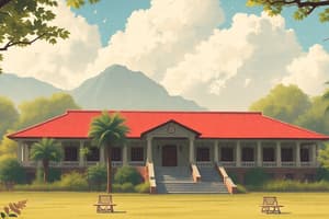
Balanga Church (also known as Sanctuario de San Luis or Our Lady of the Abandoned Church): A stunning 16th-century church located in the city of Balanga, which is recognized as a UNESCO World Heritage Site as part of the Baroque Churches of the Philippines.
-
Barasoain Church: This church, located in Malolos City, played a crucial role in the Philippine Revolution and the First Philippine Republic. It is the site where the Malolos Constitution, the first organic law of the Philippines, was drafted and ratified.
-
Malolos City: The capital city of Bulacan, Malolos is steeped in history and served as the seat of the First Philippine Republic from 1899 to 1901. The city is home to many historical landmarks, including Barasoain Church, the Malolos Cathedral, and the Malolos Convention Hall.
-
Jam Liner Bus Terminal: Known for its iconic red and yellow color scheme, this bus terminal in Cubao, Quezon City, is a prominent landmark in Bulacan and serves as a major transportation hub for the province.
-
Pandan Lake: A serene body of water that lures nature enthusiasts and birdwatchers seeking to explore the diverse flora and fauna inhabiting the area. The lake is also known for its eco-tourism and water sports activities such as kayaking and fishing.
-
Bocaue Church: Located in the municipality of Bocaue, this church is a noteworthy example of Baroque architecture in the Philippines. The church was established in the 17th century and is recognized for its unique blend of Spanish, Chinese, and Filipino influences.
-
Meycauayan Dam: A major water resource project that serves as a hub of recreational activities, including boating, fishing, and picnics. The dam is also a popular spot for photographers and nature lovers seeking to capture the beauty of the surrounding landscape.
Climate
Bulacan, like most of the Philippines, enjoys a tropical climate characterized by high temperatures and a distinct wet and dry season. The average temperature in Bulacan ranges from 22°C to 34°C throughout the year. The wet season begins in May and lasts until October, while the dry season starts in November and continues until April. The province is subject to seasonal typhoons and monsoon rains, which can cause flooding and landslides.
Bulacan's geographical features and climate have played a significant role in shaping the province's culture, economy, and history. With its diverse landscape, rich historical landmarks, and unique natural attractions, Bulacan remains a fascinating destination for travelers and locals alike.
Studying That Suits You
Use AI to generate personalized quizzes and flashcards to suit your learning preferences.
Description
Test your knowledge on Bulacan's diverse terrain, historical landmarks, and unique geographical features. Explore the province's topography, iconic churches, bustling cities, serene lakes, and major water resource projects.