Podcast
Questions and Answers
The Central Plains extend from Encounter Bay in the South to ______ in the North.
The Central Plains extend from Encounter Bay in the South to ______ in the North.
Gulf of Carpentaria
The rivers Darling and Murray are ______ rivers originating from the Southern Alps.
The rivers Darling and Murray are ______ rivers originating from the Southern Alps.
snow-fed
The ______ is a rich agricultural area that gets its ample water supply from the rivers Murray, Darling and Murrumbidgee.
The ______ is a rich agricultural area that gets its ample water supply from the rivers Murray, Darling and Murrumbidgee.
Murray Darling Basin
______ is a vast saucer shaped area of inland drainage. It is a dry area and many rivers disappear here without reaching the sea.
______ is a vast saucer shaped area of inland drainage. It is a dry area and many rivers disappear here without reaching the sea.
The ______ are drained by river Flinders and river Mitchell. They are separated from the Lake Eyre Basin by Barkley tableland and Selwyn range.
The ______ are drained by river Flinders and river Mitchell. They are separated from the Lake Eyre Basin by Barkley tableland and Selwyn range.
The plateau slopes eastwards to the Central Lowlands, South Wales and the ______.
The plateau slopes eastwards to the Central Lowlands, South Wales and the ______.
The Western Plateau occupies the ______ half of the continent and is composed of sandstone and limestone.
The Western Plateau occupies the ______ half of the continent and is composed of sandstone and limestone.
______ is a huge mass of single rock called Ayers Rock and it is incorporated within the Macdonnell Range.
______ is a huge mass of single rock called Ayers Rock and it is incorporated within the Macdonnell Range.
______ is the coastal plain located towards the south of the western plateau.
______ is the coastal plain located towards the south of the western plateau.
Some of the major deserts in Australia's Western Plateau region are the Gibson, the Great Sandy Desert and the ______.
Some of the major deserts in Australia's Western Plateau region are the Gibson, the Great Sandy Desert and the ______.
Flashcards
Coral Polyps
Coral Polyps
Tiny sea creatures that form coral reefs in warm, shallow seas.
Coral Reef
Coral Reef
A ridge-like structure in the sea formed from consolidated coral polyps.
The Central Lowlands
The Central Lowlands
Extends from Encounter Bay to the Gulf of Carpentaria.
The Murray Darling Basin
The Murray Darling Basin
Signup and view all the flashcards
Lake Eyre Basin
Lake Eyre Basin
Signup and view all the flashcards
The Carpentarian Lowlands
The Carpentarian Lowlands
Signup and view all the flashcards
The Western Plateau
The Western Plateau
Signup and view all the flashcards
Ayer's Rock
Ayer's Rock
Signup and view all the flashcards
Nullarbor Plain
Nullarbor Plain
Signup and view all the flashcards
Darwin, Wyndham & Derby
Darwin, Wyndham & Derby
Signup and view all the flashcards
Study Notes
- Australia's physical features are diverse, as shown in Fig 9.9
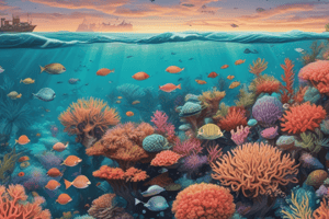
Coral Reefs
- Coral reefs are formed by tiny sea creatures called Coral Polyps
- These polyps reside in shallow, warm, salty waters.
- Coral polyps secrete calcium carbonate that forms a ridge-like structure after the polyp's death.
- Coral reefs exhibit pink, red, and white colors.
- It attracts tourists but poses hazards for ships.
- Human activities like mining can harm coral reefs and aquatic life.
Central Lowlands
- The Central Plains extend from Encounter Bay in the South to the Gulf of Carpentaria in the North.
- The Central Plains are divided into three parts.
Murray Darling Basin
- It is an agricultural area with ample water supply from the Murray River and its tributaries.
- The Darling and Murrumbidgee rivers drain nearly the whole of southeast Australia.
- The Darling and Murray rivers originate from the snow-fed Southern Alps.
Lake Eyre Basin
- Lake Eyre Basin is a vast saucer-shaped area of inland drainage.
- It is a dry area where many rivers disappear without reaching the sea.
The Carpentarian Lowlands
- It is drained by the Flinders and Mitchell rivers.
- They are separated from the Lake Eyre Basin by the Barkley Tableland and Selwyn Range.
The Western Plateau
- It occupies the western half of Australia.
- Composed of sandstone and limestone layers over igneous rocks.
- The plateau slopes eastwards to the Central Lowlands and South Wales, towards the Nullarbor Plain.
- The Hamersley, Macdonnell (near Alice Springs), and Musgrave ranges are the important mountain ranges in the Western Plateau.
- Major deserts in this region include the Gibson, Great Sandy, and Great Victoria Deserts.
- A huge single rock mass called Ayers Rock (Uluru) is incorporated within the Macdonnell Range.
Coastal Plains
- The Western Plateau drops steeply to the sea, creating an even coastline with few inlets, except in the northeast.
- The sea is shallower in the northeast, providing good harbors like Darwin, Wyndham, and Derby.
- The Nullarbor Plain is a vast coastal plain located south of the Western Plateau along the southern coast.
- Uluru briefly glows red at sunset.
Studying That Suits You
Use AI to generate personalized quizzes and flashcards to suit your learning preferences.